Other ID: COST Well No. G-1
Status: Completed
Organization(s): USGS, Woods Hole Coastal and Marine Science Center
Funding Program(s):
Principal Investigator(s): John S. Schlee
Affiliate Investigator(s): Peter A. Scholle
Information Specialist(s):
Data Type(s): Sampling: Geology
Scientific Purpose/Goals: The COST No. G-1 well was drilled between April 6 and July 26, 1976, by Ocean Production Company acting as operator for 31 participating companies. The well was drilled by the semisubmersible rig SEDCO-J in 157 ft. of water in the southwestern part of the Georges Bank basin. A total section of 16,071 ft. (4,898 m) was drilled. The COST No. G-1 well was drilled intentionally off structure in block 79 of the North Atlantic Outer Continental Shelf tract, part of Lease Sale No. 42 held in December 1979.
Vehicle(s):
Start Port/Location:
End Port/Location:
Start Date: 1976-04-06
End Date: 1976-07-26
Equipment Used: Well drilling
Information to be Derived:
Summary of Activity and Data Gathered: A total section of 16,071 ft (4,898 m) was drilled. Well G-1 bottomed in phyllite, slate and metaquartzite overlain by weakly metamorphosed dolomite, all of Cambrian age. Data from geophysical logs and examination of conventional cores, well-cuttings, and sidewall cores show that below 10,000 ft. (3,048 m), the strata has moderate porosity and low to moderate permeability and is thus considered adequate to poor reservoir rock. Above 10,000 ft. (3,000 m), the porosity ranges from 16 to 39 percent and the permeability is highly variable, ranging from 0.01 to 7100 mD. Measurements of reflectance and various organic geochemical properties suggest that the Tertiary and Cretaceous strata are not prospective for oil and gas. These sediments have not been buried deeply enough for hydrocarbon generation and the kerogen and extractable organic matter in them are thermally immature. The Jurassic rocks at the G-1 site do contain small amounts of thermally mature gas-prone kerogens, but the site has only poor to fair oil and gas source-rock potential.
Staff:
Affiliate Staff:
Notes: No WHSC cruise report; information derived from various USGS reports and publications.
Project = COST Well G-1, COST Well G-1
Location:
southwestern Georges Bank, United States, North America, North Atlantic;
| Boundaries | |||
|---|---|---|---|
| North: 40.93114 | South: 40.93059 | West: -68.3053 | East: -68.3047 |
Platform(s):
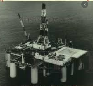 Sedco-J |
Amato, R.V., and Bebout, J.W., eds., 1980, Geologic and operational summary, COST No. G-1 Well, Georges Bank Area, North Atlantic OCS: U.S. Geological Survey Open-File Report 80-268, 117 p., URL: https://doi.org/10.3133/ofr80268.
Klitgord, K.D., and Schneider, C.M., Geophysical database of the east coast of the United States northern Atlantic margin—Velocity analyses: U.S. Geological Survey Open-File Report 94-192, https://doi.org/10.3133/ofr94192.
Scholle, P.A., and Wenkam, C.R., eds., 1982, Geological studies of the COST nos. G-1 and G-2 wells, United States North Atlantic outer continental shelf: U.S. Geological Survey Circular 861, 193 p., https://doi.org/10.3133/cir861.
Scholle, P.A., Krivoy, H.L., and Hennessy, J.L., 1980, Summary chart of geological data from the COST No. G-1 well, U.S. North-Atlantic outer continental shelf: U.S. Geological Survey Oil and Gas Investigation Chart 104, 1 sheet, URL: https://doi.org/10.3133/oc104.
| Survey Equipment | Survey Info | Data Type(s) | Data Collected |
|---|---|---|---|
| Well drilling | --- | Geology |
