Other ID: 84-1
Status: Completed
Organization(s): USGS, Woods Hole Coastal and Marine Science Center
Funding Program(s):
Principal Investigator(s): David W. Folger
Affiliate Investigator(s): R.C. Hollar - Party Chief, Meridian Ocean Systems
Information Specialist(s):
Data Type(s): Imagery: Photo, Location-Elevation: Navigation, Seismics: Boomer, Sonar: Sidescan, Sonar: Single Beam
Scientific Purpose/Goals: Geologic investigations of two nuclear craters.
Vehicle(s):
Start Port/Location: Kwajelein, Trust Territory of the Pacific Islands
End Port/Location: Kwajelein, Trust Territory of the Pacific Islands
Start Date: 1984-06-10
End Date: 1984-07-08
Equipment Used: Single channel hydrophone, Raytheon DE-719 precision echo sounder, Huntec profiling system (500-2500 Hz), Klein 531 sidescan, 35 mm camera, Motorola Falcon IV Microwave relay Mini-Ranger
Information to be Derived:
Summary of Activity and Data Gathered: In Enewetak Lagoon 12 June - 5 July; on survey 19 June - 4 July following navigation set up and area reconnaissance. This operation was the first of several phases of investigation of two nuclear test craters, OAK and KOA, in the northern part of Enewetak Atoll. Data were acquired in parallel-line grids having nominal line spacings of 26 km (85 ft) for bathymetry, and 76 m (250 ft) for sidescan sonar and sub-bottom (Huntec boomer) profiles. Tie-line data were also acquired. Additional bathymetric data were acquired by small boat. The ship was operated only during daylight hours because hazards from shallow water and proximity to the reef required maximum visibility. A mosaic of the sidescan sonar images was constructed from the field data during the operation. A tide gauge was deployed in each of the craters for bathymetric corrections, although only the KOA gauge appears to have operated successfully. Bathymetry data: 350 km; Sidescan sonar data: 210 km; Sub-bottom profiler (Huntec) data: 115 km.
Staff: Dann Blackwood, David W. Folger, Gregory Miller, Kenneth F. Parolski, James M. Robb
Affiliate Staff:
Meridian Ocean Systems
Inc. (MOS): R.C. Hollar - Party Chief
A. Pearce
S.L. Thoresen
M. Milburn; Defense Nuclear Agency (DNA): E.L. Tremba - observer
B.L. Ristvet - observer; Defense Mapping Agency (DMA): H.V. Woodworth - navigational specialist
Notes: Original Center People field contained: Dave Folger (Ch. Sci./geologist); James Robb (curator/geologist); Greg Miller (technician); Kenneth Parolski (technician); Dann Blackwood (photographer).
Project = Pacific Enewetak Atoll Crater Exploration (PEACE), Pacific Enewetak Atoll Crater Exploration (PEACE)
Location:
Enewetak Atoll, Enewetok, Marshall Islands, Trust Territory of the Pacific Islands (TTPI), North Pacific;
| Boundaries | |||
|---|---|---|---|
| North: 11.8 | South: 11.2 | West: 161.9 | East: 162.5 |
Platform(s):
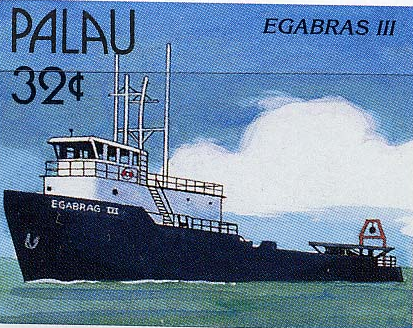 Egabrag II |
Folger, D.W., 1986, Introduction, in Folger, D.W., ed., Sea-floor observations and subbottom seismic characteristics of OAK and KOA craters, Enewetak Atoll, Marshall Islands: U.S. Geological Survey Bulletin 1678, URL: https://doi.org/10.3133/b1678.
Folger, D.W., Hampson, J.C., Robb, J.M., Woellner, R.A., Foster, D.S., and Tavares, L.A., 1986, Bathymetry of OAK and KOA craters, Chapter A in Folger, D.W., ed., Sea-floor observations and subbottom seismic characteristics of OAK and KOA craters, Enewetak Atoll, Marshall Islands: U.S. Geological Survey Bulletin 1678, URL: https://doi.org/10.3133/b1678.
| Title | Survey Equipment | Description |
|---|---|---|
| Cruise report | (document not focused on specific equipment) | Brief Chief Scientist's provisional cruise report including personnel, equipment used, data acquisition summary and cruise summary. |
| Survey Equipment | Survey Info | Data Type(s) | Data Collected |
|---|---|---|---|
| Single channel hydrophone | --- | Air Gun / Water Gun Boomer Bubble Gun Sparker Sub Bottom Profiler | 1984-006-FA-SE-001 (Collection of paper record displays of seismic data( SBP) for lines) 1984-006-FA-SE-004 (analog tape of seismic data) 1984-006-FA-SE-003 (analog tape of seismic data) 1984-006-FA-SE-002 (microfilm of) |
| Raytheon DE-719 precision echo sounder | --- | Single Beam | |
| Huntec profiling system (500-2500 Hz) | --- | Boomer | |
| Klein 531 sidescan | --- | Sidescan | 1984-006-FA-SO-001 (microfilm of ) 1984-006-FA-SO-002 (analog tape of seismic data) |
| 35 mm camera | --- | Photo | |
| Motorola Falcon IV Microwave relay Mini-Ranger | --- | Navigation |
