Other ID: P-2-85
Status: Completed
Organization(s): USGS, Woods Hole Coastal and Marine Science Center
Funding Program(s):
Principal Investigator(s): N. Terence Edgar
Affiliate Investigator(s): Juan Trias
Information Specialist(s):
Data Type(s): Electro-Magnetic: Gravity, Location-Elevation: Navigation, Seismics: Air Gun / Water Gun
Scientific Purpose/Goals: Collect high-resolution single-channel seismic reflection data near Puerto Rico and the U.S. Virgin Islands. This endeavor was secondary to the collection of gravity data by the USGS-Menlo Park personnel for the Defense Mapping Agency (DMA). This report covers the seismic reflection aspects of the cruise.
Vehicle(s):
Start Port/Location: Roosevelt Roads, Puerto Rico
End Port/Location: Roosevelt Roads, Puerto Rico
Start Date: 1985-02-28
End Date: 1985-03-11
Equipment Used: Magnavox System 5000 integrated navigation system, Single channel hydrophone, Gravity meter (wh), Air gun
Information to be Derived:
Summary of Activity and Data Gathered: Seismic reflection data gathered: Lines 22, 19, 2, 1, 18, 48, 722, 4748A, 47, 722C, 24, 54A, 41, 40-TRANS, 40, 39-TRANS, 39, 38A, 15A, 26-EAST, 14A, 15-WEST, 14B, and 15B.
Staff:
Affiliate Staff:
USGS-Menlo Park: Byron Ruppel - Gravity
Dick Tagg - Gravity
Dave Hogg - Electrical Tech.
John Erickson - Mechanical Tech.; USGS-Reston: Terence Edgar - Seismics; USGS-SJPR: Juan Trias - Seismics
Notes: Three cruises totaled 32 days at sea; 4,600 mi of seismic data. Cruise reports for Field Activities 85004, 85005 and 85007 detail the 3 legs of this project: LEG 2 - 02/28-03/11/1985 (FA 85004); LEG 3 - 03/15/-03/28/1985 (FA 85005); LEG 4 - 04/01-04/08/1985 (FA 85007).
Location:
U.S. Virgin Islands, Puerto Rico, United States, Caribbean Sea, North America, North Atlantic;
| Boundaries | |||
|---|---|---|---|
| North: 18.94785613 | South: 17.26031666 | West: -67.76432952 | East: -64.09852254 |
Platform(s):
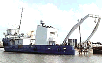
 John Wesley Powell |
Edgar, N.T., and Scanlon, K.M., 1987, Single-channel seismic-reflection profiles collected aboard R/V POWELL, Cruises P-2-85, P-3-85, P-4-85 in the nearshore waters around Puerto Rico and the Virgin Islands: U.S. Geological Survey Open-File Report 87-147, 3 p., https://doi.org/10.3133/ofr87147.
| Title | Survey Equipment | Description |
|---|---|---|
| Cruise report | (document not focused on specific equipment) | Chief Scientist's report for 3 legs of cruises (1985-004-FA, 1985-005-FA, and 1985-007-FA) listing personnel for each let as well as purpose, ship configuration, trackmap, and narrative of the cruises including comments on data collected. |
| Data inventory | (document not focused on specific equipment) | Cruise Curator's inventory of data items collected at sea for POWELL Legs P-2 (FA 85004), P-3 (FA 85005), and P-4 (FA 85007). |
| Seismic log | (document not focused on specific equipment) | Seismic log for Leg P-2 only containing airgun and gravity data, equipment configurations, start and end of lines (cover indiactes 3 cruises, so much have excluded the scans from the other activities) |
| Cruise log | (document not focused on specific equipment) | Ship's log maintained by ship's crew describing ship movement for POWELL cruises from February 28, 1985 through April 11, 1985. Some portions are blacked out. |
| Survey Equipment | Survey Info | Data Type(s) | Data Collected |
|---|---|---|---|
| Magnavox System 5000 integrated navigation system | --- | Navigation | 1985-004-FA-LN-001-01 (Trackmap for Leg 2 (pdf file) Trackline map for POWELL Leg P-2 only, including line numbers.) 1985-004-FA-LN-001-02 (Trackmap for Legs 1, 2, 3 and 4 (pdf file) Composite trackmap for POWELL Legs P-1 (see InfoBank), P-2 (FA 85004), P-3 (FA 85005), and P-4 (FA 85007).) |
| Single channel hydrophone | --- | Air Gun / Water Gun Boomer Bubble Gun Sparker Sub Bottom Profiler | 1985-004-FA-SE-001 ( Collection of paper record displays of seismic data( AIR) for lines ) 1985-004-FA-SE-002 (microfilm of ) |
| Gravity meter (wh) | --- | Gravity | NGDC MGD77 data |
| Air gun | --- | Air Gun / Water Gun |