Other ID: AST 85-10
Status: Completed
Organization(s): USGS, Woods Hole Coastal and Marine Science Center
Funding Program(s):
Principal Investigator(s): Ronald C. Circe, Harley J. Knebel
Affiliate Investigator(s):
Information Specialist(s): Ronald C. Circe
Data Type(s): Location-Elevation: Navigation, Seismics: Boomer, Sonar: Sidescan
Scientific Purpose/Goals: To collect high-resolution seismic reflection profiles and sidescan sonar records to define the geologic and geophysical characteristics of the bottom and sub-bottom sediments in lower Delaware Bay. By analyzing these data we hope to determine (1) the shallow sub-bottom stratigraphy and the Holocene and pre-Holocene depositional history of the bay; (2) the types of bottom morphology; and (3) possible areas of sediment accumulation and erosion.
Vehicle(s):
Start Port/Location: Woods Hole, MA
End Port/Location: Woods Hole, MA
Start Date: 1985-07-07
End Date: 1985-07-20
Equipment Used: EG&G 234, Klein 531 sidescan, Loran-C, Raytheon radar, Visual navigation, Single channel hydrophone
Information to be Derived:
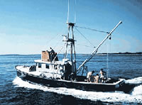
Summary of Activity and Data Gathered: Number of days at sea: 4 days in transit between Woods Hole, MA, and Lewes, DE; 10 days surveying. R/V ASTERIAS left Woods Hole, MA for Lewes, DE on July 7 with Dick Colburn and Ken Parolski aboard. Harley Knebel and Ron Circe drove to Lewes, DE on July 8, meeting ASTERIAS at the University of Delaware Marine Science Facility in the evening. Surveying within Delaware Bay began on July 9 and continued each day through July 18. During the survey, equipment malfunctions were few and of short duration, and only about 1.5 days were lost because of inclement weather. The ship returned each night to Lewes, DE where berthing space and other logistical support were graciously provided by the University of Delaware Marine Science Facility. On the evening of July 12, Harley Knebel got off ASTERIAS, turning the Chief Scientist's duties over to Ron Circe. Visitors aboard the boat during the survey included: Tom Pickett and Dick Benson, Delaware Geological Survey (July 11); Jeff Williams, USGS, and S.R. Khan, Bangladesh (July 15); and David Hall, New Jersey Geological Survey (July 16). Wayne Newell and Byron Stone, USGS, visited the boat and USGS personnel on the evening of July 9. On July 19, ASTERIAS departed for Woods Hole with Dick Colburn and Ron Circe aboard; Ken Parolski returned to Woods Hole by car. The ASTERIAS arrived in Woods Hole on the morning of July 20. Uniboom records: 592 line km; Klein sidescan sonar data: 592 line km.
Staff: Ronald C. Circe, Harley J. Knebel, Kenneth F. Parolski, S. Jeffress Williams
Affiliate Staff:
Tom Picknett - Delaware Geological Survey (DGS); Dick Benson - DGS; S.R. Khan - student
Bangladesh; David Hall - New Jersey Geological Survey (NJGS)
Notes: Original Center People field contained: Harley Knebel - Ch. Sci. 07/09-12; Ron Circe - Ch. Sci. 07/13-18, Data Curator; Ken Parolski - Electronics Technician; Jeff Williams.
Project = Coastal, Estaurine, and Lacustrine Studies, Coastal, Estaurine, and Lacustrine Studies
Location:
Delaware Bay, Delaware, New Jersey, United States, North America, North Atlantic;
| Boundaries | |||
|---|---|---|---|
| North: 39.16667 | South: 38.75833 | West: -75.2617 | East: -74.91667 |
Platform(s):
 Asterias |
| Title | Survey Equipment | Description |
|---|---|---|
| Cruise report | (document not focused on specific equipment) | Chief Scientist's report including personnel, purpose, equipment, tabulated information, brief cruise summary, and a trackmap. |
| Navigation log | Loran-C | Watchstander's log describing line start and end times, Loran time delays, notes on obstacles, weather conditions, ship traffic. |
| Geophysics log | (document not focused on specific equipment) | Watchstander's log describing line start and end times, notes on acquisition and conditions. |
| Survey Equipment | Survey Info | Data Type(s) | Data Collected |
|---|---|---|---|
| EG&G 234 | --- | Boomer | |
| Klein 531 sidescan | --- | Sidescan | 1985-022-FA-SO-001 ( Collection of paper record displays of sidescan sonar data for lines ) 1985-022-FA-SO-002 (microfilm of ) |
| Loran-C | --- | Navigation | 1985-022-FA-LN-002 (Digital tape(s) of NV, NV-FINAL, ) 1985-022-FA-LN-001 (Navigation trackline plot for field activity 85022) |
| Raytheon radar | --- | Navigation | |
| Visual navigation | --- | Navigation | |
| Single channel hydrophone | --- | Air Gun / Water Gun Boomer Bubble Gun Sparker Sub Bottom Profiler | 1985-022-FA-SE-001 (microfilm of ) 1985-022-FA-SE-002 (analog tape of seismic data) |