Other ID: NOAA summer mission, Leg 2; JSL 1818
Status: Completed
Organization(s): USGS, Woods Hole Coastal and Marine Science Center
Funding Program(s):
Principal Investigator(s): Page Valentine
Affiliate Investigator(s):
Information Specialist(s): Page Valentine
Data Type(s): Sonar: Sidescan, Imagery: Video, Imagery: Photo, Sampling: Biology, Sampling: Geology, Location-Elevation: Navigation
Scientific Purpose/Goals: Submersible, sidescan, sampling, and bathymetric operation in eastern Georges Bank canyons and on adjacent slope; sedimentary processes, currents, megabenthic fauna and habitats.
Vehicle(s):
Start Port/Location: Woods Hole, MA
End Port/Location: Woods Hole, MA
Start Date: 1986-07-20
End Date: 1986-08-01
Equipment Used: Klein 531 sidescan, Video camera - deep sea, Nikonos camera, Push corer (wh), Northstar 6000 LORAN-C, Northstar 7000 LORAN-C
Information to be Derived: Samples and chemical analysis; Habitat maps;
Summary of Activity and Data Gathered: 12 kHz data: 83.7 nm (155.01 km); 100 kHz sidescan data: 51.2 nm (94.82 km); sediment samples: 88; video of current meter recovery. Mooring recovery assistance for MARY LOUISE (FA 86012) by SEA-LINK: 1 (#301 deployed FA 85024 GYRE Jul. 24-26, 1985).
Staff: Page Valentine, Steve Mateus
Affiliate Staff:
Joseph Uzmann
NMFS; Douglas Pezzack
Canada Dept. Fisheries and Oceans; Tom Meyer
NOAA; Dave Bieber
Bieber Assoc.
Notes: NOTE: Submersible on this cruise was used to help recover mooring 301 detailed in cruise report 86012. Mooring recovery activity not recorded in this cruise report.
Project = Biostratigraphic and Depositional Framework - U.S. Atlantic Margin, Biostratigraphic and Depositional Framework - U.S. Atlantic Margin
Location:
Rodgers Pass, Gulf of Maine, Corsair Canyon, Fundian Canyon, Northeast Channel, eastern Georges Bank, United States, North America, North Atlantic;
| Boundaries | |||
|---|---|---|---|
| North: 42.27776054 | South: 41.21631338 | West: -68.17445045 | East: -65.62622677 |
Platform(s):
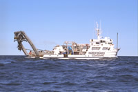 Edwin Link | 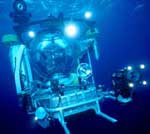 Johnson Sea-link |
Valentine, P.C., and Commeau, J.A., 1989, The Gulf of Maine rutile province; accumulation of fine-grained, authigenic titanium oxide from sandstone and shale source rocks: U.S. Geological Survey Open-File Report 89-532, https://doi.org/10.3133/ofr89532.
| Title | Survey Equipment | Description |
|---|---|---|
| Cruise report | (document not focused on specific equipment) | Chief scientist's cruise report including personnel, purpose, equipment, tabulation of information, and trackmaps. |
| Survey Equipment | Survey Info | Data Type(s) | Data Collected |
|---|---|---|---|
| Klein 531 sidescan | --- | Sidescan | |
| Video camera - deep sea | --- | Video | |
| Nikonos camera | --- | Photo | |
| Push corer (wh) | --- | Biology Geology | |
| Northstar 6000 LORAN-C | --- | Navigation | |
| Northstar 7000 LORAN-C | --- | Navigation |
