Other ID: S2-87-CV
Status: Completed
Organization(s): USGS, Woods Hole Coastal and Marine Science Center
Funding Program(s):
Principal Investigator(s): James E. Dodd
Affiliate Investigator(s):
Information Specialist(s): James E. Dodd
Data Type(s): Location-Elevation: Navigation, Electro-Magnetic: Gravity, Sonar: Single Beam
Scientific Purpose/Goals: Collect gravity and bathymetry data around the Cape Verde Islands.
Vehicle(s):
Start Port/Location: Mindelo, Cape Verde
End Port/Location: Praia, Cape Verde
Start Date: 1987-03-26
End Date: 1987-04-25
Equipment Used: Racal/Decca Hyperfix, LaCoste-Romberg gravimeter G-179, Echosounder, Magnavox System 5000 integrated navigation system
Information to be Derived:
Summary of Activity and Data Gathered: The ship left Mindelo (Sao Vicente Island, Cape Verde Islands) on March 26, 1987. Two lines from Leg 1 were re-run using GPS navigation because all Racal shore-based navigation had been moved to the eastern and southern Cape Verde Islands. On March 27th, operations moved to Sal Island where Racal Survey had their radio navigation net set up. After a one-hour calibration, the survey was continued. We had to coordinate the survey at sea with the resources on land. While data are normally processed every few days, here the schedule was increased so that as soon as an area was surveyed the data from that area were processed so we could be sure we wouldn't have to return there. This leap-frogging system was made possible through the hard work of the Racal shore team and the help of many of the local Cape Verdeans. We moved south, surveying around the islands of Sal, Boa Vista, Maio, and Sao Tiago. There was a two-day port stop in Praia to exchange some of the crew from April 9-11. The cruise finished up the area around Sao Tiago and then moved on to survey around the islands of Fogo and Brava. After completing the survey, the ship docked in Praia (Sao Tiago) on April 25 to tie the gravity data to the gravity station there.
Staff: Catherine Delorey, James E. Dodd, George R. Driscoll, David Mason, Carol M. Parmenter, Richard Rendigs
Affiliate Staff:
John Ryland
Racal Survey; Dave McCracken
Racal Survey; Dave Ellison
Racal Survey; Brian Franklin
J. Marr
Notes: For gravity data, contact Michael A. Prugger, Office of GEOINT Sciences, National Geospatial-Intelligence Agency (NGA); Michael.A.Prugger@nga.mil; 314-676-0863.
Project = Defense Mapping Agency Gravity, Defense Mapping Agency Gravity
Location:
Cape Verde Islands, Africa, North Atlantic;
| Boundaries | |||
|---|---|---|---|
| North: 18 | South: 13 | West: -27 | East: -22 |
Platform(s):
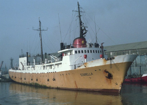
 Starella |
Folger, D.W., Irwin, Barry J., McCullough, James R., Bouse, Robin M., Polloni, Christopher F., Dodd, James E., and O'Brien, T. F., 1990, Map showing free-air gravity anomalies around the Cape Verde Islands: U.S. Geological Survey Miscellaneous Field Studies Map MF-2098-A, scale 1:750,000, URL: https://pubs.er.usgs.gov/publication/mf2098A.
| Title | Survey Equipment | Description |
|---|---|---|
| Cruise report | (document not focused on specific equipment) | Chief Scientist's cruise report including personnel, purpose, equipment, tabulated information, and cruise narrative. |
| Survey Equipment | Survey Info | Data Type(s) | Data Collected |
|---|---|---|---|
| Racal/Decca Hyperfix | --- | Navigation | |
| LaCoste-Romberg gravimeter G-179 | --- | Gravity | 1987-009-FA-GP-001 (Digital tape(s) of NV/GRAV ARCHIVE, ) |
| Echosounder | --- | Single Beam | 1987-009-FA-SE-001 ( Collection of paper record displays of seismic data( 12K) for lines ) |
| Magnavox System 5000 integrated navigation system | --- | Navigation | 1987-009-FA-LN-001 (Digital tape(s) of NV/GRAV ARCHIVE, ) |