Other ID: AM1-88
Status: Completed
Organization(s): USGS, Woods Hole Coastal and Marine Science Center
Funding Program(s):
Principal Investigator(s): Michael Bothner
Affiliate Investigator(s):
Information Specialist(s):
Data Type(s): Location-Elevation: Navigation, Sampling: Biology, Sampling: Geology, Sonar: Sidescan
Scientific Purpose/Goals: The purpose of this cruise is to collect sediment cores which will be analyzed for radioisotopes, heavy metals and toxic organic compounds.
Vehicle(s):
Start Port/Location: Charlestown Navy Yard, Charlestown, MA
End Port/Location: Charlestown Navy Yard, Charlestown, MA
Start Date: 1988-05-04
End Date: 1988-05-05
Equipment Used: Piston corer, Grab sampler, Hydroplastic corer, Motorola Falcon IV Microwave relay Mini-Ranger, Megapulse Accufix 500 LORAN-C, Klein 531 sidescan
Information to be Derived: Suspended sediment concentrations;
Summary of Activity and Data Gathered: 35 samples.
Staff: Michael Bothner, Dave Lubinski, David Nichols, Carol M. Parmenter, Richard Rendigs, William Winters
Affiliate Staff:
Thorton Tyson (Alternate); Wayne Trulli (Battelle Labs)
Notes: The information is needed to evaluate the potential of sediments for accumulating contaminants that will be added to Massachusetts Bay through the new ocean outfall. Funds for the sampling and analytical work will be paid to the Survey by the Massachusetts Water Resources Authority. This cruise is the first opportunity to follow up on our in-house pilot study with outside funding. Information derived from pre-cruise report; no post cruise report found. Original Center People field contained: Mike Bothner, Dave Lubinski, Dave Nichols, Carol Parmenter, Bill Winters, Rick Rendigs; Thorton Tyson (Alternate).
Location:
Massachusetts Bay, Massachusetts, United States, North America, North Atlantic,
| Boundaries | |||
|---|---|---|---|
| North: 43 | South: 41.25 | West: -71.5 | East: -69 |
Platform(s):
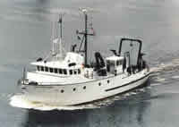 Argo Maine |
Bothner, M.H., and Butman, Bradford (eds.), 2007, Processes influencing the transport and fate of contaminated sediments in the coastal ocean—Boston Harbor and Massachusetts Bay: U.S. Geological Survey Circular 1302, 89 p., https://doi.org/10.3133/cir1302.
| Survey Equipment | Survey Info | Data Type(s) | Data Collected |
|---|---|---|---|
| Piston corer | --- | Geology | 1988-003-FA-SC-001 (CORE samples) |
| Grab sampler | --- | Biology Geology | |
| Hydroplastic corer | --- | Geology | |
| Motorola Falcon IV Microwave relay Mini-Ranger | --- | Navigation | 1988-003-FA-LN-001 (Digital tape(s) of NV/BT-MINIRANGER, SSS-KLEIN LINE 1, SSS-KLEIN LINE 1,2, ) |
| Megapulse Accufix 500 LORAN-C | --- | Navigation | |
| Klein 531 sidescan | --- | Sidescan | 1988-003-FA-SO-001 (Digital tape(s) of NV/BT-MINIRANGER, SSS-KLEIN LINE 1, SSS-KLEIN LINE 1,2, ) |
