Other ID: none
Status: Completed
Organization(s): USGS, Woods Hole Coastal and Marine Science Center
Funding Program(s):
Principal Investigator(s): William J. Strahle
Affiliate Investigator(s):
Information Specialist(s):
Data Type(s): Time Series: Mooring (physical oceanography)
Scientific Purpose/Goals: Recover Mooring #385 and partially deploy Mooring #391 at Mobile Site A.
Vehicle(s):
Start Port/Location:
End Port/Location:
Start Date: 1991-12-07
End Date: 1991-12-07
Equipment Used: Bottom platform
Information to be Derived: Time series data;
Summary of Activity and Data Gathered: Mooring recovered: 1 (#385 deployed FA 91023 TOMMY MUNRO July 30, 1991). Mooring partially deployed: 1 (#391, remainder deployed FA 91053 VERRILL Dec. 11, 1991; recovered FA 92030 TOMMY MUNRO May 10, 1992).
Staff:
Affiliate Staff:
USGS
Dauphin Island Sea Lab
Notes: No field activity reports; information derived from mooring logs.
Location:
Mobile Bay, Alabama, United States, Gulf of Mexico, North America, North Atlantic;
| Boundaries | |||
|---|---|---|---|
| North: 30 | South: 29.9 | West: -88.2 | East: -88.1 |
Platform(s):
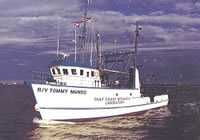 Tommy Munro |
| Survey Equipment | Survey Info | Data Type(s) | Data Collected |
|---|---|---|---|
| Bottom platform | --- | Mooring (physical oceanography) |
