Other ID: AM2-92
Status: Completed
Organization(s): USGS, Woods Hole Coastal and Marine Science Center
Funding Program(s):
Principal Investigator(s): Michael Bothner
Affiliate Investigator(s):
Information Specialist(s):
Data Type(s): Sampling: Geology, Location-Elevation: Navigation, Imagery: Video
Scientific Purpose/Goals: To collect sediment samples, video and surface sediments.
Vehicle(s):
Start Port/Location: Boston, MA
End Port/Location: Woods Hole, MA
Start Date: 1992-05-15
End Date: 1992-05-21
Equipment Used: Slow corer, Gravity corer, Van Veen grab sampler, DGPS, Loran-C, Video camera - deep sea
Information to be Derived:
Summary of Activity and Data Gathered: The objective of this cruise was to collect core and grab samples at 8 regional stations each in Massachusetts and Cape Cod Bays. The samples will be analyzed for contaminant inventories, rates of sedimentary processes, physical and geotechnical properties, and benthic ecology. Good weather and the absence of major equipment problems made it possible to exceed expectations for the cruise. Additional grab samples were collected at three locations in the northern section of Massachusetts Bay where our developing sediment database revealed low sample coverage. Three locations on Stellwagen Bank were sampled in order to characterize the chemistry of coarse sands present in this high energy environment. All of the samples scheduled for collection in early June at our two long-term monitoring sites near the future outfall were efficiently sampled on this cruise. This saved a considerable logistical effort normally expended during the mooring cruises aboard the USCGC WHITE HEATH. We tested a high quality color video camera attached to our grab sampler at each station and found it to be a significant help to our operations. The video revealed the presence of boulders at one location proposed as a long-term monitoring site and allowed us to explore nearby areas for a more suitable sampling location. The camera also allowed an assessment of sample quality in terms of sediment loss or disturbance. Finally, the camera showed when and why malfunctions in the grab sampler occurred so that repairs could be made without delay. On the cruise track between Stations 17 and 3, we crossed the northern tip of Stellwagen Bank and observed a number of humpback and finback whales. On one occasion, two whales swam just under the vessel providing an unusually good photo opportunity. One whale was observed to slap the sea surface with its tail at 10-30 second intervals for no less than 10 minutes, an activity known as "tail bobbing." Although we were prepared to collect feces of whales for analysis of the bacterium spore Clostridium perfringens, no whale feces were observed on the sea surface. This measurement is of interest because Clostridium perfringens is a tracer of sewage sludge from Boston and it is important to estimate the contribution of this tracer from natural sources. Scientists from the Center for Coastal Research in Provincetown, Massachusetts, who frequently are in close proximity to the whales in this area, have agreed to help provide material to address this question. Sediment Samples: 74 (32 grab samples, 42 gravity cores).
Staff: Richard Rendigs, William Winters, Marilyn ten Brink, Joan Brazier, Adam Brown, Chuck Mason, Carol M. Parmenter
Affiliate Staff:
MWRA - Anne Canaday
Ken Keay
Notes: Project = Studies of circulation and contaminant transport in MA coastal waters, Studies of circulation and contaminant transport in MA coastal waters
Information from Foghorn: hydraulically damped corer, 4\" diam. gravity corer, Teflon Van Veen grab sampler, camera system, Simrad echo sounder
Location:
Massachusetts Bay, Cape Cod Bay, Stellwagen Bank, east of Stellwagen Bank, Massachusetts, United States, North America, North Atlantic;
| Boundaries | |||
|---|---|---|---|
| North: 42.55029 | South: 42.25885 | West: -70.6565 | East: -70.21835 |
Platform(s):
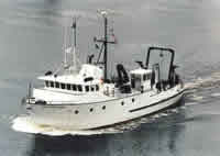
 Argo Maine |
Bothner, M.H., and Butman, Bradford (eds.), 2007, Processes influencing the transport and fate of contaminated sediments in the coastal ocean—Boston Harbor and Massachusetts Bay: U.S. Geological Survey Circular 1302, 89 p., https://doi.org/10.3133/cir1302.
Crusius, J., Bothner, Michael H., and Sommerfield, Christopher K., 2004, Bioturbation depths, rates and processes in Massachusetts Bay sediments inferred from modeling of 210Pb and 239+240Pu profiles: Estuarine, Coastal and Shelf Science, v. 61 no. 4, doi: 10.1016/j.ecss.2004.07.005.
| Title | Survey Equipment | Description |
|---|---|---|
| Cruise report | (document not focused on specific equipment) | Chief Scientist's cruise report including cruise summary, station location map, personnel, purpose, equipment, tabulated information, table of sample locations and descriptions, sampling and macrofauna sampling notes. |
| Survey Equipment | Survey Info | Data Type(s) | Data Collected |
|---|---|---|---|
| Slow corer | --- | Geology | |
| Gravity corer | --- | Geology | |
| Van Veen grab sampler | --- | Geology | 1992-007-FA-SC-001 (GRAB samples) |
| DGPS | --- | Navigation | |
| Loran-C | --- | Navigation | |
| Video camera - deep sea | --- | Video |