Other ID: DE92-10, Leg 2
Status: Completed
Organization(s): USGS, Woods Hole Coastal and Marine Science Center
Funding Program(s):
Principal Investigator(s): Page Valentine
Affiliate Investigator(s):
Information Specialist(s):
Data Type(s): Sonar: Sidescan, Sonar: Single Beam, Imagery: Photo, Imagery: Video, Sampling: Geology, Location-Elevation: Navigation
Scientific Purpose/Goals: Collaborative reasearch with USGS and NMFS; echo sounding, sidescan sonar surveys, video, and bottom sampling of selected areas on the northern edge of Georges Bank to map sedimentary environments and biological habitats.
Vehicle(s):
Start Port/Location: Woods Hole, MA
End Port/Location: Woods Hole, MA
Start Date: 1992-09-28
End Date: 1992-10-06
Equipment Used: Klein 531 sidescan, Q-MIPS sidescan sonar system, Simrad EC - 810 echo sounder, Osprey camera system, Van Veen grab sampler, GPS (wh), Loran-C
Information to be Derived:
Summary of Activity and Data Gathered: 856 line km of sidescan sonar data in 3 areas comprising 139 sq. km of continuous coverage; color video camera deployed at 31 sites; 8 sediment samples taken.
Staff: Nancy K. Soderberg, Eric A. Schmuck, Barbara A. Seekins
Affiliate Staff:
Jim Vaughn
Elizabeth Gier
Notes: Original Center People field contained: Eric Schmuck, Nancy Soderberg, Barbara Seekins, Jim Vaughn, Elizabeth Gier.
Project = EEZ shelf mapping - Eastern Georges Bank, EEZ shelf mapping - Eastern Georges Bank
Location:
northern edge of Georges Bank, United States, North America, North Atlantic;
| Boundaries | |||
|---|---|---|---|
| North: 42.10583 | South: 41.916 | West: -67.591 | East: -67.3295 |
Platform(s):
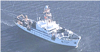 Delaware II |
| Title | Survey Equipment | Description |
|---|---|---|
| Cruise report | (document not focused on specific equipment) | Chief Scientist's cruise report including personnel, purpose, equipment, tabulated information, video and sediment sample station locations, trackmap. |
| Survey Equipment | Survey Info | Data Type(s) | Data Collected |
|---|---|---|---|
| Klein 531 sidescan | --- | Sidescan | |
| Q-MIPS sidescan sonar system | --- | Sidescan | |
| Simrad EC - 810 echo sounder | --- | Single Beam | |
| Osprey camera system | --- | Photo Video | |
| Van Veen grab sampler | --- | Geology | 1992-025-FA-SC-001 (GRAB samples) |
| GPS (wh) | --- | Navigation | 1992-025-FA-LN-001 (Floppy disk(s) containing NAV GPS LORAN, NAV GPS LORAN, NAV GPS LORAN, NAV GPS LORAN, NAV GPS LORAN, NAV GPS LORAN, NAV GPS LORAN, NAV GPS LORAN, NAV GPS LORAN, NAV GPS LORAN, NAV GPS LORAN, NAV GPS LORAN, NAV GPS LORAN, ) |
| Loran-C | --- | Navigation |
