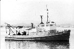
Other ID: JEAN-A 1993 Leg 01
Status: Completed
Organization(s): USGS, Woods Hole Coastal and Marine Science Center
Funding Program(s):
Principal Investigator(s): Kenneth F. Parolski
Affiliate Investigator(s): Juan Luis Trias - USGS BAMG-San Juan
Information Specialist(s):
Data Type(s): Location-Elevation: Navigation, Seismics: Boomer, Seismics: Sub Bottom Profiler, Sampling: Geology, Sampling: Biology, Sampling: Chemistry
Scientific Purpose/Goals: Collect sediment samples and high-resolution seismic reflections profiles; dive.
Vehicle(s):
Start Port/Location: Las Mareas Harbor, Guayama, Puerto Rico
End Port/Location: Las Mareas Harbor, Guayama, Puerto Rico
Start Date: 1993-10-27
End Date: 1993-11-05
Equipment Used: DGPS, Huntec profiling system (500-2500 Hz), 3.5 kHz, Shipek grab, Van Veen grab sampler, SCUBA
Information to be Derived:
Summary of Activity and Data Gathered: Beach sampling was conducted 10/06/93; shallow water sediment samples were collected 10/10/93 aboard a rubber boat.
Staff: Barry Irwin, Kenneth F. Parolski
Affiliate Staff:
Juan Trias - ch. sci.; Milton Carlo - geologist
San Juan
Notes:
Project = Puerto Rico Marine Geologic Maps, Puerto Rico Marine Geologic Maps
Location:
Grappler Bank, south coast, Puerto Rico, United States, Caribbean Sea, North America, North Atlantic;
| Boundaries | |||
|---|---|---|---|
| North: 17.99841 | South: 17.62308 | West: -67.0605 | East: -65.61035 |
Platform(s):
 Jean A |
| Title | Survey Equipment | Description |
|---|---|---|
| Cruise report | (document not focused on specific equipment) | Chief Scientist's cruise report including personnel, purpose, equipment, tabulated information, sample locations. |
| Navigation log | DGPS | GPS and DGPS navigation printout with 5-minute fixes containing julian day, time, latitude, longitude, speed, bearing and hand annotations for start and end of lines. |
| Cruise log | (document not focused on specific equipment) | Seismic log with start and end of lines, waypoints (time only recorded) for grab samples. |
| Survey Equipment | Survey Info | Data Type(s) | Data Collected |
|---|---|---|---|
| DGPS | --- | Navigation | 1993-025-FA-LN-001-01 ( Seismic trackline map.
) 1993-025-FA-LN-002 (Floppy disk(s) containing NAV-GPSL1-4, NAV-DGPSL4A-11, NAV-DGPSL14-18*, NAV-DGPSL12-25, NAV-GPSGRABS1-25, NAV-DGPS, NAV-DGPSSTA35-73, NAV-RAWDGPS, NAV-EDITDGPS, ) |
| Huntec profiling system (500-2500 Hz) | --- | Boomer | |
| 3.5 kHz | --- | Sub Bottom Profiler | 1993-025-FA-SE-001 (Collection of paper record displays of seismic data (3.5K) for lines ) 1993-025-FA-SE-002 (microfilm of ) |
| Shipek grab | --- | Geology | |
| Van Veen grab sampler | --- | Geology | |
| SCUBA | --- | Biology Chemistry Geology |