Other ID: none
Status: Completed
Organization(s): USGS, Woods Hole Coastal and Marine Science Center
Funding Program(s):
Principal Investigator(s): William Schwab
Affiliate Investigator(s):
Information Specialist(s): Jane Denny
Data Type(s): Imagery: Photo, Location-Elevation: Navigation, Sampling: Biology, Sampling: Geology, Seismics: Air Gun / Water Gun, Seismics: Sub Bottom Profiler, Sonar: Single Beam, Seismics: Boomer, Sonar: Sidescan
Scientific Purpose/Goals: Assess the shallow sediment framework (continuation of regional environmental study of New York Bight area).
Vehicle(s):
Start Port/Location: Caven Point, NJ
End Port/Location: Woods Hole, MA
Start Date: 1996-05-01
End Date: 1996-06-09
Equipment Used: DGPS, SIS1000 Sidescan sonar, Water gun (wh), 3.5 kHz, Echosounder, Grab sampler, SIS1000 Chirp Sonar, Benthos model 372 camera and strobe, Single channel hydrophone, GeoPulse uniboom
Information to be Derived:
Summary of Activity and Data Gathered:
Staff: Michael Casso, VeeAnn Cross, William Danforth, Jane Denny, Eric Haase, Barry Irwin, Jeremy Loss, Linda Lotto, David Nichols, Thomas O'Brien, Kenneth F. Parolski, Edwin Roworth, William Schwab
Affiliate Staff:
Shawn Dadisman; Mead Allison - TAMU
Stefan E. Ioannou - U. Toronto
Sarah Pratt - Rutgers
Benjamin Raken - Wesleyan U.
Notes: Original Center People field contained: William Schwab, Tom O'Brien, Barry Irwin, William Danforth, Shawn Dadisman, Dave Nichols, Linda Lotto, Jeremy Loss, Jane Denny, Eric Haase, Ken Parolski, Ed Roworth, VeeAnn Cross, Michael Casso.
Project = EEZ Sea Floor Mapping: NY/NJ Metropolitan Area, EEZ Sea Floor Mapping: NY/NJ Metropolitan Area
Information from Foghorn: Datasonics SIS-1000 Sea floor Mapping System, 15 in3 watergun (2-channel), ODOM 3.5 kHz sub-bottom profiler, GeoPulse boomer sub-bottom profiler, Fathometer, Sediment grab sampler, and Camera system;
Location:
inner Continental Shelf, New York Bight Apex, Fire Island, New York, United States, North America, North Atlantic;
| Boundaries | |||
|---|---|---|---|
| North: 40.67346345 | South: 40.15182105 | West: -73.97918701 | East: -73.01269228 |
Platform(s):
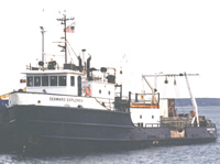 Seaward Explorer |
Butman, B., 1998, Mapping the sea-floor geology offshore of the New York - New Jersey metropolitan region: U.S. Geological Survey Fact Sheet 133-98, https://doi.org/10.3133/fs13398.
Butman, B., Danforth, W.W., Knowles, S.C., May, B., and Serrett, L., 2002, Sea floor topography and backscatter intensity of the Historic Area Remediation Site (HARS), offshore of New York, based on multibeam surveys conducted in 1996, 1998, and 2000: U.S. Geological Survey Open-File Report 00-503, DVD-ROM, URL: https://doi.org/10.3133/ofr2000503.
Butman, B., Danforth, W.W., Schwab, W.C., and Buchholtz ten Brink, M.R., 1998, Multibeam bathymetric and backscatter maps of the upper Hudson Shelf Valley and adjacent shelf, offshore of New York: U.S. Geological Survey Open-File Report 98-616, https://doi.org/10.3133/ofr98616.
Butman, B., Gutierrez, B.T., Buchholtz ten Brink, M.R., Schwab, W.C., Blackwood, D.S., Mecray, E.L., and Middleton, T.J., 2003, Photographs of the sea floor offshore of New York and New Jersey: U.S. Geological Survey Open-File Report 01-470, DVD-ROM, URL: https://doi.org/10.3133/ofr2001470.
Foster, D.S., Swift, B.A., and Schwab, W.C., 2000, Stratigraphic framework maps of the nearshore area of southern Long Island from Fire Island to Montauk Point, New York: U.S. Geological Survey Open-File Report 99-559, https://doi.org/10.3133/ofr99559.
Hill, J.C., Schwab, W.C., and Danforth, W.W., 2001, Archive of sidescan-sonar data and DGPS navigation data collected during USGS cruise SEAX 96004, New York Bight, 1 May-9 June, 1996: U.S. Geological Survey Open-File Report 2001-95, https://doi.org/10.3133/ofr0195.
Hill, J.C., Schwab, W.C., and Foster, D.S., 2000, Archive of boomer subbottom data collected during USGS Cruise SEAX 96004, New York Bight, 1 May - 9 June 1996: U.S. Geological Survey Open-File Report 00-340, DVD-ROM, URL: https://doi.org/10.3133/ofr00340.
Hill, J.C., Schwab, W.C., and Foster, D.S., 2001, Archive of Datasonics SIS-1000 chirp subbottom data collected during USGS cruise SEAX 96004, New York Bight, 1 May - 9 June, 1996: U.S. Geological Survey Open-File Report 2001-96, https://doi.org/10.3133/ofr0196.
Hill, J.C., Schwab, W.C., and Foster, D.S., 2000, Archive of water gun subbottom data collected during USGS Cruise SEAX 96004, New York Bight, 1 May - 9 June, 1996: U.S. Geological Survey Open-File Report 00-396, DVD-ROM, URL: https://doi.org/10.3133/ofr00396.
Schwab, W.C., Corso, W., Allison, M.A., Butman, B., Denny, J.F., Lotto, L.L., Danforth, W.W., Foster, D.S., O'Brien, T.F., Nichols, D.R., Irwin, B.J., and Parolski, K.F., 1997, Mapping the sea-floor geology offshore of the New York - New Jersey metropolitan area using sidescan sonar: Preliminary report: U.S. Geological Survey Open-File Report 97-61, https://doi.org/10.3133/ofr9761.
Schwab, W.C., Denny, J.F., Foster, D.S., Lotto, L.L., Allison, M.A., Uchupi, E., Swift, B.A., Danforth, W.W., Thieler, E.R., and Butman, B., 2002, High-resolution Quaternary seismic stratigraphy of the New York Bight Continental Shelf: U.S. Geological Survey Open-File Report 2002-152, DVD-ROM, URL: https://doi.org/10.3133/ofr2002152.
FAN 1996-004-FA has data viewable in the GeoMappApp/Virtual Ocean applications. To view this data in these applications go to http://www.geomapapp.org/ and http://www.virtualocean.org/. See the instructions for locating USGS data in these applications. You can also view the imagery created from the SEGY data at https://cmgds.marine.usgs.gov/images.php?cruise=1996-004-FA.
| Survey Equipment | Survey Info | Data Type(s) | Data Collected |
|---|---|---|---|
| DGPS | --- | Navigation | 1996-004-FA-LN-002-01 (Processed navigation) 1996-004-FA-LN-001-01 (Ship's trackmap.) Water gun navigation 1996-004-FA-LN-003 (DGPS navigation printout.) Boomer navigation Chirp navigation |
| SIS1000 Sidescan sonar | --- | Sidescan | 1996-004-FA-SO-001 (Sidescan sonar data) |
| Water gun (wh) | --- | Air Gun / Water Gun | |
| 3.5 kHz | --- | Sub Bottom Profiler | |
| Echosounder | --- | Single Beam | |
| Grab sampler | --- | Biology Geology | 1996-004-FA-SC-001 (GRAB samples) |
| SIS1000 Chirp Sonar | --- | Sub Bottom Profiler | 1996-004-FA-SE-002-03 (CHIRP subbottom data - SEG-Y data files and images.) Chirp seismic data |
| Benthos model 372 camera and strobe | --- | Photo | |
| Single channel hydrophone | --- | Air Gun / Water Gun Boomer Bubble Gun Sparker Sub Bottom Profiler | 1996-004-FA-SE-001 ( Collection of paper record displays of seismic data( H2O) for lines ) 1996-004-FA-SE-002-01 (Water Gun Data - SEG-Y data files and images.) 1996-004-FA-SE-002-02 (Boomer subbottom data - SEG-Y data files and images.) Boomer seismic data (Boomer subbottom data - SEG-Y format.) Water gun data |
| GeoPulse uniboom | --- | Boomer |
