Other ID: IB S-43-00-NR
Status: Completed
Organization(s): USGS, Woods Hole Coastal and Marine Science Center
Funding Program(s):
Principal Investigator(s): Jeffrey List
Affiliate Investigator(s):
Information Specialist(s): Amy Farris
Data Type(s): Location-Elevation: Profiles, Location-Elevation: Transects
Scientific Purpose/Goals: Scheduled monthly shoreline survey on Cape Hatteras.
Vehicle(s):
Start Port/Location:
End Port/Location:
Start Date: 2000-05-21
End Date: 2000-05-26
Equipment Used: Swash II ATV
Information to be Derived:
Summary of Activity and Data Gathered:
Staff: Andrew Fox, Barry Irwin, Jeffrey List
Affiliate Staff:
Notes: Low tide: 6:28 AM, 7:16 AM.
Location:
North Carolina outer banks, Duck survey area (Corolla to Oregon Inlet), Hatteras survey area (Oregon Inlet to Hatteras), North Carolina, United States, North America, North Atlantic;
| Boundaries | |||
|---|---|---|---|
| North: 36.59430582 | South: 35.28520431 | West: -76.1682 | East: -74.86080497 |
Platform(s):
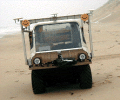 Swash-II |
Thieler, E.R., Foster, D.S., Mallinson, D.M., Himmelstoss, E.A., McNinch, J.E., List, J.H.,and Hammar-Klose, E.S., 2013, Quaternary geophysical framework of the northeastern North Carolina coastal system: U.S. Geological Survey Open-File Report 2011-1015, https://doi.org/10.3133/ofr20111015.
| Survey Equipment | Survey Info | Data Type(s) | Data Collected |
|---|---|---|---|
| Swash II ATV | --- | Profiles Transects |
