Other ID: IB H-49-00-CH
Status: Completed
Organization(s): USGS, Woods Hole Coastal and Marine Science Center
Funding Program(s):
Principal Investigator(s): John Bratton
Affiliate Investigator(s): Tom Boyd, Naval Research Lab
Information Specialist(s):
Data Type(s): Environmental Data: CTD, Sampling: Chemistry, Environmental Data: Conductivity, Sampling: Biology, Sampling: Geology, Location-Elevation: Navigation
Scientific Purpose/Goals: Coring and resampling of porewater from site MD99-2205 sampled in June 1999 from R/V MARION DUFRESNE (DFRN99026).
Vehicle(s):
Start Port/Location: Norfolk, VA
End Port/Location: Norfolk, VA
Start Date: 2000-03-17
End Date: 2000-03-18
Equipment Used: SBE 9 CTD, Niskin bottle, Trident subsurface porewater conductivity probe, Gravity corer, Box corer, DGPS, Pore water sampling
Information to be Derived:
Summary of Activity and Data Gathered: Two gravity cores were collected at a site near Parker Creek as follows: PK2000-1 38deg33.9395 N, 76deg26.6730 W, 16.4 m, recovery 240 cm, 8 porewater samples at 25 cm spacing; PK2000-2 38deg33.9418 N, 76deg26.6826 W, 16.2 m, recovery 230 cm, 23 porewater samples at 10 cm spacing. Samples analyzed onshore for total methane by Pohlman at NRL, chloride by ion chromatograph at MBL by Bratton.
Staff: John Bratton
Affiliate Staff:
Tom Boyd
NRL: sampled marine
brackish
and fresh water for bacterial cultures to study degradation of dissolved organic matter; John Pohlman
NRL (contractor): assisted Boyd and Bratton
collected box core from Miocene sea floor outcrop for Peter Vogt from NRL.
Notes:
Project = Chesapeake Bay Ecosystem History, Chesapeake Bay Ecosystem History
Location:
Chesapeake Bay, Norfolk, Virginia to Annapolis, Maryland, United States, North America, North Atlantic;
| Boundaries | |||
|---|---|---|---|
| North: 38.11823213 | South: 37.98894836 | West: -76.2993287 | East: -76.13061423 |
Platform(s):
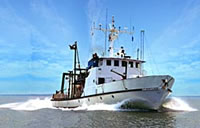
 Cape Henlopen |
Bratton, J.F., 2010, The three scales of submarine groundwater flow and discharge across passive continental margins: The Journal of Geology, v. 118 no. 5, doi: 10.1086/655114.
| Survey Equipment | Survey Info | Data Type(s) | Data Collected |
|---|---|---|---|
| SBE 9 CTD | --- | CTD | |
| Niskin bottle | --- | Chemistry | |
| Trident subsurface porewater conductivity probe | --- | Conductivity | |
| Gravity corer | --- | Geology | |
| Box corer | --- | Biology Geology | |
| DGPS | --- | Navigation | |
| Pore water sampling | --- | Chemistry |