Other ID: CB02001
Status: Completed
Organization(s): USGS, Woods Hole Coastal and Marine Science Center
Funding Program(s):
Principal Investigator(s): David Twichell
Affiliate Investigator(s): Mark Rudin, UNLV
Information Specialist(s): David Twichell
Data Type(s): Biological Field Study: Experiments (biological), Sampling: Geology, Imagery: Photo, Imagery: Video, Location-Elevation: Navigation
Scientific Purpose/Goals: Collect vibracores and gravity cores from the western part of Lake Mead to describe the sedimentary structures and composition of post-impoundment sediment in this part of the lake.
Vehicle(s):
Start Port/Location: Lake Mead Marina, NV
End Port/Location: Lake Mead Marina, NV
Start Date: 2002-05-29
End Date: 2002-06-06
Equipment Used: Alpine Vibracorer, DGPS, Gravity corer, P-code GPS
Information to be Derived:
Summary of Activity and Data Gathered: Vibracores: 16; gravity cores: 12.
Staff: VeeAnn Cross, Kenneth F. Parolski
Affiliate Staff:
Keith Ludwig (USGS
St. Pete)
assist with vibracoring; Mark Rudin
UNLV - Health Physics Dept. - Co-Ch. Sci.; Brenda Buck
UNLV - Geology Dept.; Robin Howley
UNLV - Geology Dept.; Thomas Hickson
St. Thomas U. - Geology Dept.
Notes: Note that the cruise has been delayed 2 weeks because of problems with the coring barge. Original Center People field contained: Kenneth Parolski, coring mobilization and coring technician; VeeAnn Cross, GIS and data integration; Keith Ludwig (USGS, St. Pete), assist with vibracoring.
Project = Lake Mead Sediment Study, Lake Mead Sediment Study
Information from Foghorn: P-code GPS receiver and laptop with GIS and Blue Marble software to interface between Plugger and GIS;
Location:
Boulder Basin, Las Vegas Bay, Lake Mead, Nevada, Arizona, United States, North America;
| Boundaries | |||
|---|---|---|---|
| North: 36.15 | South: 36 | West: -114.87 | East: -114.5 |
Platform(s):
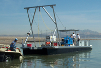 UNLV Coring Barge |
Twichell, D.C., and Cross, V.A., 2009, Surficial geology of the floor of Lake Mead (Arizona and Nevada) as defined by sidescan-sonar imagery, lake-floor topography, and post-impoundment sediment thickness: U.S. Geological Survey Open-File Report 2009-1150, CD-ROM, https://doi.org/10.3133/ofr20091150.
| Survey Equipment | Survey Info | Data Type(s) | Data Collected |
|---|---|---|---|
| Alpine Vibracorer | --- | Geology | 2002-017-FA-NL-001 (Field operations coring log: collection information for 29 cores including dates, locations, weather, procedures, etc.) 2002-017-FA-NL-002 (Visual core description log: lithologic descriptions for cores.) |
| DGPS | --- | Navigation | |
| Gravity corer | --- | Geology | |
| P-code GPS | --- | Navigation |
