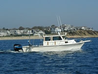
Other ID: none
Status: Completed
Organization(s): USGS, Woods Hole Coastal and Marine Science Center
Funding Program(s):
Principal Investigator(s): David Foster
Affiliate Investigator(s):
Information Specialist(s): David Foster
Data Type(s): Location-Elevation: Navigation
Scientific Purpose/Goals: We will be testing equipment and mapping areas of interest in Nantucket Sound in the area of Horseshoe Shoal. The survey will include high-resolution sub-bottom, bathymetry, and sidescan sonar acquisition.
Vehicle(s):
Start Port/Location: Woods Hole, MA
End Port/Location: Woods Hole, MA
Start Date: 2002-10-15
End Date: 2002-10-29
Equipment Used: DGPS, HYPACK
Information to be Derived: Sea floor map;
Summary of Activity and Data Gathered: The SEA Submetrix system was tested with new 117 kHz transducers. The Knudsen Chirp was tested in Waquoit Bay. Data were not acquired due to marginal to unsatisfactory weather conditions. The systems were functional and our testing objectives were met.
Staff: William Danforth, David Foster, Barry Irwin, Charles Worley
Affiliate Staff:
Notes:
Project = Seafloor Mapping, Seafloor Mapping
Location:
Nantucket Sound, Massachusetts, United States, North America, North Atlantic;
| Boundaries | |||
|---|---|---|---|
| North: 41.58333 | South: 41.41667 | West: -70.5833 | East: -70.41667 |
Platform(s):
 Rafael |
| Survey Equipment | Survey Info | Data Type(s) | Data Collected |
|---|---|---|---|
| DGPS | --- | Navigation | |
| HYPACK | --- | Navigation |