Other ID: none
Status: Completed
Organization(s): USGS, Woods Hole Coastal and Marine Science Center
Funding Program(s):
Principal Investigator(s): John Crusius
Affiliate Investigator(s): Matt Charette (WHOI)
Information Specialist(s): Dirk Koopmans
Data Type(s): Environmental Data: Radon, Geochemical: Surveys (geochemical), Imagery: Photo, Location-Elevation: Navigation, Environmental Data: CTD
Scientific Purpose/Goals: Initial deployment of radon mapping system on Sep. 30th.
Vehicle(s):
Start Port/Location: Waquoit Bay, MA
End Port/Location: Waquoit Bay, MA
Start Date: 2004-09-30
End Date: 2004-09-30
Equipment Used: RAD7 radon detection instrument, Submersible pumps, YSI Sound velocity CTD (wh), Digital camera, GPS (wh)
Information to be Derived:
Summary of Activity and Data Gathered: Measured radon activities and salinities from surface waters, with a goal of identifying groundwater discharge sites.
Staff: John Bratton, John Crusius, Sarah Kelsey, Dirk Koopmans
Affiliate Staff:
Matt Charette
Meagan Gonneae (WHOI)
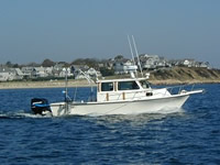
Notes: USGS vessel R/V RAFAEL used for 1 day, Sep. 30th. Original Center People field contained: boat driver; John Crusius; John Bratton; Dirk Koopmans; Sarah Kelsey.
Project = Atlantic Coastal Groundwater, Atlantic Coastal Groundwater
Location:
Waquoit Bay, Falmouth, Mashpee, Massachusetts, United States, North America, North Atlantic;
| Boundaries | |||
|---|---|---|---|
| North: 41.58333 | South: 41.55 | West: -70.55 | East: -70.5 |
Platform(s):
 Rafael |
Bratton, J.F., 2007, The importance of shallow confining units to submarine groundwater flow, in Sanford, W., Langevin, C., Polemio, M., and Povinec, P., eds., A New Focus on Groundwater-Seawater Interactions: International Association of Hydrological Sciences, v. 312.
Crusius, J., Bratton, J.F., and Charette, M., 2005, Putting radon to work—Identifying coastal ground-water discharge sites: U.S. Geological Survey Open-File Report 2004-1381, 2 p., URL: https://doi.org/10.3133/ofr20041381.
| Survey Equipment | Survey Info | Data Type(s) | Data Collected |
|---|---|---|---|
| RAD7 radon detection instrument | --- | Radon | |
| Submersible pumps | --- | Surveys (geochemical) | |
| YSI Sound velocity CTD (wh) | --- | CTD | |
| Digital camera | --- | Photo | 2004-050-FA-PH-001 (Deck photos of field activity operations) |
| GPS (wh) | --- | Navigation |