Other ID: none
Status: Completed
Organization(s): USGS, Woods Hole Coastal and Marine Science Center
Funding Program(s):
Principal Investigator(s): David Twichell
Affiliate Investigator(s): Lee Edmiston, Apalachicola Bay National Estuarine Research Reserve
Information Specialist(s):
Data Type(s): Imagery: Photo, Location-Elevation: Navigation, Seismics: Sub Bottom Profiler, Sonar: Sidescan, Sonar: Sound Velocity, Sonar: Interferometric
Scientific Purpose/Goals: Complete sea floor mapping of Apalachicola Bay using the RAFAEL to map areas deeper than 2 m and the ASV IRIS for mapping areas shallower than 2 m.
Vehicle(s):
Start Port/Location: Apalachicola, FL
End Port/Location: Apalachicola, FL
Start Date: 2006-05-29
End Date: 2006-06-27
Equipment Used: EdgeTech 424 chirp sub-bottom profiler, Digital camera, Real Time Kinematic GPS, SEA SWATHplus-M 234 kHz, Edgetech 4200 sidescan, Klein 3000, Sensor - SVP
Information to be Derived:
Summary of Activity and Data Gathered: This field season marked the second year of surveying in Apalachicola Bay. The goal of the mapping project was to provide an updated map of the distribution of oyster beds in the bay. Continuous coverage sidescan sonar imagery and bathymetric data were used to achieve this goal, and high-resolution chirp profiles were used to define the geologic framework upon which the oyster beds are set. The bay is shallow (average depth 2.5 m), and the crests of most of the oyster beds are in water depths less than 1 m. Consequently the entire area could not be surveyed using the RAFAEL. IRIS, the newly acquired ASV, was used to map the shallow areas. This was the first use of this system, and it proved quite successful. This year's field operation was conducted during late May and June. The RAFAEL collected data during 25 days of the 29-day field program and IRIS collected data during 14 days. Aboard RAFAEL RTK GPS navigation, Klein sidescan sonar imagery, Submetrix interferometric bathymetry, and chirp sub-bottom profiles were collected in digital form along 1492 km of trackline. IRIS collected RTK GPS navigation, EdgeTech sidescan sonar imagery, single-beam bathymetry, and chirp sub-bottom data in digital form along 148 km of tracks. From the two platforms data (all in digital form) were collected along 1640 km of survey lines.
Staff: Brian Andrews, Emile Bergeron, Jane Denny, Barry Irwin, Thomas O'Brien, David Twichell, Charles Worley
Affiliate Staff:
Lee Edmiston
Apalachicola National Estuarine Research Reserve; Bill Stevenson
NOAA Coastal Services Center
Notes: Original Center People field contained: Barry Irwin (boat captain); Charles Worley (electronics technician on RAFAEL); Emile Bergeron (electronics technician for IRIS); Thomas O'Brien (electronics technician for IRIS); Jane Denny (data processor); Brian Andrews (data processor); Dave Twichell (chief scientist).
Project = Apalachicola Bay Habitat Mapping, Apalachicola Bay Habitat Mapping
Location:
Apalachicola Bay, Florida, United States, Gulf of Mexico, North America, North Atlantic;
| Boundaries | |||
|---|---|---|---|
| North: 29.78333 | South: 29.58333 | West: -85.1667 | East: -84.75 |
Platform(s):
 Rafael | 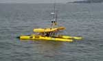 Iris |
Bergeron, E., Worley, C.W., O'Brien, T.F., 2007, Progress in development of shallow-water mapping systems by the U.S. Geological Survey: Sea Technology, v. 48 no. 6, pp. 10–15.
Cross, V.A., Twichell, D.C., Foster, D.S., and O'Brien, T.F., 2012, Apalachicola Bay interpreted seismic horizons and updated IRIS chirp seismic-reflection data: U.S. Geological Survey Open-File Report 2012-1003, URL: https://doi.org/10.3133/ofr20121003.
Osterman, L.E., Twichell, David C., and Poore, Richard Z., 2009, Holocene evolution of Apalachicola Bay, Florida: Geo-Marine Letters, v. 29 no. 6, doi: 10.1007/s00367-009-0159-1.
Twichell, D., Edmiston, L., Andrews, B., Stevenson, W., Donoghue, J., Poore, R., and Osterman, L., 2010, Geologic controls on the recent evolution of oyster reefs in Apalachicola Bay and St. George Sound, Florida: Estuarine, Coastal and Shelf Science, v. 88 no. 3, pp. 385–394, doi: 10.1016/j.ecss.2010.04.019.
Twichell, D.C., Andrews, B.D., Edmiston, H.L., and Stevenson, W.R., 2007, Geophysical mapping of oyster habitats in a shallow estuary; Apalachicola Bay, Florida: U.S. Geological Survey Open-File Report 2006-1381, https://doi.org/10.3133/ofr20061381.
Twichell, D.C., Pendleton, E.A., Poore, R.Z., Osterman, L.E., and Kelso, K.W., 2009, Vibracore, radiocarbon, microfossil, and grain-size data from Apalachicola Bay, Florida: U.S. Geological Survey Open-File Report 2009-1031, URL: https://doi.org/10.3133/ofr20091031.
| Survey Equipment | Survey Info | Data Type(s) | Data Collected |
|---|---|---|---|
| EdgeTech 424 chirp sub-bottom profiler | --- | Sub Bottom Profiler | 2006-001-FA-SE-002 (Autonomous Surface Vehicle (ASV) IRIS - Seismic profile data in EdgeTech FSSB-424 (4-24 kHz)) |
| Digital camera | --- | Photo | 2006-001-FA-PH-001 (Deck photos of field activity operations) |
| Real Time Kinematic GPS | --- | Navigation | |
| SEA SWATHplus-M 234 kHz | --- | Interferometric | Bathymetry GIS data |
| Edgetech 4200 sidescan | --- | Sidescan | 2006-001-FA-SO-002 (RAW IRIS DATA - EdgeTech 4200FS (100/400 kHz) collected from Autonomous Surface Vehicle (ASV) IRIS.) |
| Klein 3000 | --- | Sidescan | Sidescan mosaic |
| Sensor - SVP | --- | Sound Velocity |
