Other ID: none
Status: Completed
Organization(s): USGS, Woods Hole Coastal and Marine Science Center
Funding Program(s):
Principal Investigator(s): Richard Signell
Affiliate Investigator(s): Al Plueddemann, WHOI
Information Specialist(s): Ellyn Montgomery
Data Type(s): Environmental Data: Current, Location-Elevation: Navigation, Seismics: Sub Bottom Profiler, Sonar: Multibeam, Sonar: Interferometric
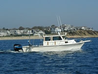
Scientific Purpose/Goals: RAFAEL will be used to obtain multibeam bathymetry and chirp data for a 1 km long section of Middle Ground, a tidal sand ridge. Simultaneous ADCP sections across and along the ridge will be made from the REMUS AUV supported by the R/V HURRICANE (WHOI REMUS Group RHIB).
Vehicle(s):
Start Port/Location: Falmouth Harbor, MA
End Port/Location: Falmouth Harbor, MA
Start Date: 2006-09-27
End Date: 2006-09-27
Equipment Used: REMUS AUV, GPS (wh), EdgeTech 424 chirp sub-bottom profiler, DGPS, SEA SWATHplus-M 234 kHz
Information to be Derived: Sea floor map;
Summary of Activity and Data Gathered: One survey of the ridge and adjacent sandwave fields was completed. A high-resolution map of the region was generated from the processed data. REMUS ADCP data from two runs of the transect pattern was also collected.
Staff: William Danforth, Ellyn Montgomery
Affiliate Staff:
Garret Duffy
Geological Survey of Canada
observer; Amy Kukulya
WHOI
REMUS tech. (on HURRICANE)
Notes: Original Center People field contained: Bill Danforth (lead tech); Ellyn Montgomery (REMUS tech, on HURRICANE).
Information from Foghorn: EdgeTech 424 Sub-bottom;SEA Swath Bathymetry System;pre-RTK GPS;
Location:
Vineyard Sound, Massachusetts, United States, North America, North Atlantic;
| Boundaries | |||
|---|---|---|---|
| North: 41.48333 | South: 41.46667 | West: -70.6778 | East: -70.65556 |
Platform(s):
 Rafael |
| Survey Equipment | Survey Info | Data Type(s) | Data Collected |
|---|---|---|---|
| REMUS AUV | --- | Current | |
| GPS (wh) | --- | Navigation | |
| EdgeTech 424 chirp sub-bottom profiler | --- | Sub Bottom Profiler | |
| DGPS | --- | Navigation | |
| SEA SWATHplus-M 234 kHz | --- | Interferometric |