Other ID: none
Status: Completed
Organization(s): USGS, Woods Hole Coastal and Marine Science Center
Funding Program(s):
Principal Investigator(s): William Winters
Affiliate Investigator(s): Tim Collett - USGS-Denver
Information Specialist(s): William Winters
Data Type(s): Environmental Data: Sediment Properties
Scientific Purpose/Goals: Study gas hydrates in a natural reservoir.
Vehicle(s):
Start Port/Location: near Milne Pt., AK
End Port/Location: near Milne Pt., AK
Start Date: 2007-02-05
End Date: 2007-02-18
Equipment Used: Dipole Shear Sonic Imager (DSI)
Information to be Derived:
Summary of Activity and Data Gathered: Actual travel dates: 28 Jan. 2007 to 16 Feb. 2007 for WHSC personnel. Field work was preceded by safety training in Anchorage. Assortment of activities related to acquisition of natural sediment samples with and without gas hydrate in the pore space. Well logs. Sediment and pore-content analyses in the field and home-based laboratories including: physical properties, gas and pore-water geochemistry. Summary of activities is provided in the U.S. Dept. of Energy National Energy Technology Laboratory newsletter.
Staff: Philip Bernard, David Mason, William Waite, William Winters
Affiliate Staff:
Tim Collett - USGS-Denver; Warren Agena - USGS-Denver; Tom Lorenson - USGS-Denver; Bob Hunter - ASRC; Larry Vendl - BPX; Micaela Weeks - BPX; Ray Boswell - NETL/DOE; Kelly Rose - NETL/DOE; Eilis Rosenbaum - NETL/DOE; Rajeev Sinha - DGH; Dennis Gamberg - OMNI; Grant Mabry - OMNI; Rick Colwell - OSU; Marta Torres - OSU
Notes: Original Center People field contained: Bill Winters (Science - field); Bill Waite (Science - field); Dave Mason (Logistics); P.J. Bernard (Shipping).
Project = BP Exploration (Alaska) Mount Elbert 01 well, BP Exploration (Alaska) Mount Elbert 01 well
Equipment updated by VAC based on Bill Waite email.
Location:
Milne Point, Simpson Sound, North Slope, Alaska, United States, Beaufort Sea, North America, Arctic Ocean;
| Boundaries | |||
|---|---|---|---|
| North: 70.45565 | South: 70.45465 | West: -149.4107 | East: -149.40972 |
Platform(s):
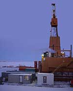 Doyon 14 Drill Rig |
Lee, M.W., and Waite, William F., 2008, Estimating pore-space gas hydrate saturations from well log acoustic data: Geochemistry Geophysics Geosystems, G3, v. 9 no. Q07008, doi: 10.1029/2008GC002081.
| Survey Equipment | Survey Info | Data Type(s) | Data Collected |
|---|---|---|---|
| Dipole Shear Sonic Imager (DSI) | Collected Compressional, Shear and Stoneley Wavespeeds | Sediment Properties |
