Other ID: R-1-08-MY
Status: Completed
Organization(s): USGS, Woods Hole Coastal and Marine Science Center
Funding Program(s):
Principal Investigator(s): Lawrence Poppe
Affiliate Investigator(s):
Information Specialist(s): Lawrence Poppe, Nancy K. Soderberg
Data Type(s): Imagery: Photo, Imagery: Video, Location-Elevation: Navigation, Sampling: Biology, Sampling: Geology, Visual Identification: Species ID
Scientific Purpose/Goals: Ground truth NOAA survey H11346 of the entrance to Edgartown, Massachusetts with bottom sampling and photography. Field work was focused on the sampling/photography.
Vehicle(s):
Start Port/Location: Woods Hole, MA
End Port/Location: Woods Hole, MA
Start Date: 2008-09-08
End Date: 2008-09-09
Equipment Used: DGPS, SeaBOSS, Digital camera
Information to be Derived:
Summary of Activity and Data Gathered: Thirty seven stations were occupied (28 sites on September 8, 2008, 9 sites on September 9, 2008). Still photographs and video were collected at all stations; sediment samples were collected at 34 of the stations. Sediment samples were not collected at the 3 stations where boulders and dense shells were present.
Staff: Dann Blackwood, Barry Irwin, Katherine McMullen
Affiliate Staff:
Notes: Original Center People field contained: Barry Irwin (Boat Operator); Dann Blackwood (Photographer/SEABOSS Operator); Kate McMullen (Field Technician).
Project = Sea and Lake Floor Mapping: Data off Cape Cod, Sea and Lake Floor Mapping: Data off Cape Cod
Location:
Edgartown Harbor, Nantucket Sound, Martha's Vineyard, Massachusetts, United States, North America, North Atlantic;
| Boundaries | |||
|---|---|---|---|
| North: 41.46667 | South: 41.36667 | West: -70.5667 | East: -70.43333 |
Platform(s):
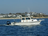
 Rafael |
Poppe, L.J., McMullen, K.Y., Foster, D.S., Blackwood, D.S., Williams, S.J., Ackerman, S.D., Moser, M.S., and Glomb, K.A., 2010, Geological interpretation of the sea floor offshore of Edgartown, Massachusetts: U.S. Geological Survey Open-File Report, https://doi.org/10.3133/ofr20091001.
| Survey Equipment | Survey Info | Data Type(s) | Data Collected |
|---|---|---|---|
| DGPS | --- | Navigation | |
| SeaBOSS | --- | Surveys (biological) Experiments (biological) Species ID Photo Video Geology Biology | 2008-012-FA-SC-001 (Edgartown Harbor sediment samples from 34 of 37 stations.) 2008-012-FA-PH-001-01 (This is a subset of the original dataset. Test photos and misfired photos showing nothing but water column or sea surface were removed. Also, the photos were downsized into browse and thumbnail images in preparation for publication. ) 2008-012-FA-SC-001-01 (Grain Size Analysis: 37 samples. Lab numbers AX148 to AX184 in L. Poppe's East Coast Sediment Database.) |
| Digital camera | --- | Photo | 2008-012-FA-PH-002 (17 deck/operations photos by Dann Blackwood.) |