Other ID: none
Status: Completed
Organization(s): USGS, Woods Hole Coastal and Marine Science Center
Funding Program(s):
Principal Investigator(s): Carolyn Ruppel
Affiliate Investigator(s):
Information Specialist(s): Carolyn Ruppel
Data Type(s): Location-Elevation: Navigation, Imagery: Photo
Scientific Purpose/Goals: Oblique aerial photography from Beaufort coast southward into lake province for ID of seep features during freeze-up.
Vehicle(s):
Start Port/Location: Barrow, AK
End Port/Location: Barrow, AK
Start Date: 2009-10-23
End Date: 2009-10-24
Equipment Used: GPS (wh), Digital camera
Information to be Derived:
Summary of Activity and Data Gathered: Flew a total of 7 hours on 23 and 24 October from Barrow southward toward Atqasuk and east of the Meade River (23 October) and from Barrow south and then east as far as almost Deadhorse, entirely within the lake province.
Staff: Carolyn Ruppel, Charles Worley
Affiliate Staff:
UAF: Katey Walter Anthony
Benjamin Gaglioti
Laura Oxtoby
Notes:
Project = Methane Hydrate - Dept. of Energy, Methane Hydrate - Dept. of Energy
Location:
central and eastern North Slope, Alaska, United States, North America;
| Boundaries | |||
|---|---|---|---|
| North: 71.44117 | South: 69.225 | West: -157.8516 | East: -143.96484 |
Platform(s):
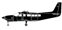 CESSNA 208B TAIL N715HE |
Wooller, M.J., Ruppel, C., Pohlman, J.W., Leigh, M.B., Heintz, M., and Anthony, K.W., 2009, Permafrost gas hydrates and climate change; lake-based seep studies on the Alaskan north slope: Fire in the Ice, U.S. Department of Energy/National Energy Technology Laboratory, Methane Hydrate Newsletter, Summer 2009, v. 9 no. 3, pp. 6–9, URL: http://www.netl.doe.gov/File%20Library/Research/Oil-Gas/methane%20hydrates/MHNewsSummer09.pdf.
| Survey Equipment | Survey Info | Data Type(s) | Data Collected |
|---|---|---|---|
| GPS (wh) | --- | Navigation | |
| Digital camera | --- | Photo |
