Other ID: OC463
Status: Completed
Organization(s): USGS, Woods Hole Coastal and Marine Science Center
Funding Program(s):
Principal Investigator(s): Jason Chaytor
Affiliate Investigator(s): Chris Baxter, URI
Information Specialist(s): Jason Chaytor
Data Type(s): Biological Field Study: Experiments (biological), Location-Elevation: Navigation, Sampling: Biology, Sampling: Geology, Seismics: Sub Bottom Profiler
Scientific Purpose/Goals: Coring ops.
Vehicle(s):
Start Port/Location: Woods Hole, MA
End Port/Location: Woods Hole, MA
Start Date: 2010-06-15
End Date: 2010-06-21
Equipment Used: Box corer, Knudsen 1600 USB 1.2 kW with 2 Massa transducers (3.5 kHz), DGPS, Piston corer
Information to be Derived:
Summary of Activity and Data Gathered: The objective of this coring cruise was to investigate in detail the stratigraphy and age of several significant slope failures along the continental slope and rise south of Rhode Island and Massachusetts. Twenty-three piston cores were collected (~110 m of core). This project is a collaborative effort between the URI Department of Ocean Engineering and the USGS Woods Hole Coastal and Marine Science Center.
Staff: Katherine McMullen, Uri Ten Brink
Affiliate Staff:
Tim Elfers
WCMG; Kevin O'Toole; Cody Jones
UMass; Genevieve Cauchon-Voyer
Laval University; Rich Genovesi
URI; Chris O'Reilly
URI; Matt Jenson
URI; Don DeGroot
UMass; Ethan Beise
Bryant University; Maia ten Brink
Princeton University
Notes: Project = Potential Tsunami Sources, Potential Tsunami Sources
Information from Foghorn: Corer - piston, Box corer;
Location:
Georges Bank, United States, North America, North Atlantic;New York Bight, New York, New Jersey, United States, North America, North Atlantic;,
| Boundaries | |||
|---|---|---|---|
| North: 41.01307 | South: 39.19821 | West: -71.499 | East: -68.8623 |
Platform(s):
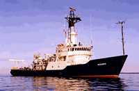
 Oceanus |
Chaytor, J.D., ten Brink, U.S., Baxter, C.D., Brothers, D.S., and Twichell, D.C, 2012, Submarine Landslides on the Slope and Rise, Southern New England Continental Margin, USA [abs.]: , 34th International Geological Congress. Brisbane, Australia, August 5-10, 2012.
Chaytor, J.D., ten Brink, U.S., Baxter, C.D.P., Brothers, D.S., and Hallam, T.D., Morphology and Age of the Southern New England Landslide Zone [abs.-: , AGU 2015 Fall Meeting. San Francisco, CA, December 2015.
Chaytor, J.D., ten Brink, U.S., Twichell, D.C., Baxter, C.D.P., Hallam, T.D., Brother, D., 2011, Submarine Landslides along the U.S. Atlantic Margin: Their Distribution, Failure Processes and Age [abs.]: , 2011 Fall AGU Meeting. December 5-9, 2011, San Francisco, CA.
| Survey Equipment | Survey Info | Data Type(s) | Data Collected |
|---|---|---|---|
| Box corer | --- | Biology Geology | |
| Knudsen 1600 USB 1.2 kW with 2 Massa transducers (3.5 kHz) | --- | Sub Bottom Profiler | |
| DGPS | --- | Navigation | |
| Piston corer | --- | Geology |