Other ID: R/V Endeavor cruise 486 (EN486)
Status: Completed
Organization(s): USGS, Woods Hole Coastal and Marine Science Center
Funding Program(s):
Principal Investigator(s): Bradford Butman
Affiliate Investigator(s): Bruce Keafer (Chief Scientist), Woods Hole Oceanographic Institution; Don Anderson (PI), Woods Hole Oceanographic Institution
Information Specialist(s): Bradford Butman
Data Type(s): Environmental Data: CTD, Environmental Data: Current, Geochemical: Experiments (geochemical), Imagery: Photo, Location-Elevation: Navigation, Sampling: Geology
Scientific Purpose/Goals: Measure erodability of surficial sediments using Gust Erosion Microcosm System (GEMS), obtain conductivity-temperture-depth profiles (CTD), obtain samples of surficial sediments for texture analysis.
Vehicle(s):
Start Port/Location: Narragansett, RI
End Port/Location: Narragansett, RI
Start Date: 2010-10-13
End Date: 2010-10-23
Equipment Used: ADCP, Gust Erosion Microcosm System (GEMS), Digital camera, GPS (wh), Craib corer, SBE 9 CTD, Slow corer
Information to be Derived:
Summary of Activity and Data Gathered: The principal objective of this cruise (led by scientists at the Woods Hole Oceanographic Instituion (WHOI)) was to obtain samples of the surficial sediments using a Craib corer at approximately 110 stations in the Gulf of Maine for analysis of Alexandrium cyst concentration. This fall 2010 distribution of cysts will be used as input to numerical models for forecasting Alexandrium blooms in the spring of 2011. USGS participation was to measure sediment erodability (using a GEMS system) on cores collected using the USGS slow corer at 5-10 stations as time permitted. Samples of the surficial sediment for texture analysis by USGS were obtained from the sediment samples collected by WHOI for cyst analysis and water-column profiles from a USGS CTD attached to the Craib corer were obtained for analysis of the suspended sediment distribution. Data gathered include: ~150 CTD casts; ~100 surficial sediment samples for texture analysis; erodability measurements at 6 stations (two cores each station) using GEMS.
Staff: Jonathan Borden, Patrick Dickhudt
Affiliate Staff:
Bruce Keafer
Chief Scientist (WHOI); WHOI personnel (12 total)
Notes: Sampling the sediments for the cyst concentration was the primary objective of this cruise. Sampling was suspended and/or steaming slowed for about two days (~10/15 and 10/21) of the cruise due to high seas. Coring for erosion analysis was successfully carried out at six stations along the Massachusetts-New Hampshire-Maine-Canadian coast; however, due to time constraints cores were not obtained in Jordan or Wilkenson Basin. This was the first time the GEMS system was used by USGS at sea.
Location:
Gulf of Maine, United States, North America, North Atlantic,
| Boundaries | |||
|---|---|---|---|
| North: 45.01142 | South: 42.37478 | West: -70.9937 | East: -66.35742 |
Platform(s):
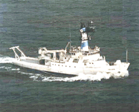 Endeavor |
Butman, B., Aretxabaleta, A.L., Dickhudt, P.J., Dalyander, P.S., Sherwood, C.R., Anderson, D.M., Keafer, B.A., and Signell, R.P., 2014, Investigating the importance of sediment resuspension in Alexandrium fundyense cyst population dynamics in the Gulf of Maine: Deep-Sea Research Part II—Topical Studies in Oceanography, vol. 103, p. 79-95, https://doi.org/10.1016/j.dsr2.2013.10.011.
| Survey Equipment | Survey Info | Data Type(s) | Data Collected |
|---|---|---|---|
| ADCP | --- | Current | |
| Gust Erosion Microcosm System (GEMS) | --- | Experiments (geochemical) | |
| Digital camera | --- | Photo | |
| GPS (wh) | --- | Navigation | |
| Craib corer | --- | Geology | |
| SBE 9 CTD | --- | CTD | 2010-077-FA-OM-001-02 (Seabird raw CTD files with revised headers and renumbered file names. The header information in the raw files has been modified to contain additional metadata. The file names have been changed to EN486_station#_lowering# to reflect the WHOI station numbers. The CTD was attached to the WHOI corer and if multiple lowerings were required to obtain a good core at a station, mulitple CTD casts were aquired.) 2010-077-FA-OM-001-01 (Raw CTD data as downloaded from CTD aboard ship. File names are default as assigned at download and are numbered sequentially (152 casts).) 2010-077-FA-OM-001-03 (SeaBird raw CTD data with revised headers and filenames converted to Seabird CNV format.) |
| Slow corer | --- | Geology |
