Other ID: R-41-11-NJ
Status: Completed
Organization(s): USGS, Woods Hole Coastal and Marine Science Center
Funding Program(s): Hurricane Sandy - Coastal Vulnerability and Resource Assessment, Delmarva Peninsula (AE03FKC)
Principal Investigator(s): Brian Andrews, Jennifer Miselis
Affiliate Investigator(s): Jen Miselis, St. Pete
Information Specialist(s): Brian Andrews
Data Type(s): Location-Elevation: Navigation, Sonar: Sidescan, Sonar: Sound Velocity, Sonar: Interferometric, Seismics: Sub Bottom Profiler
Scientific Purpose/Goals: Map the shallow geologic framework of Barnegat Bay, NJ
Vehicle(s):
Start Port/Location: Toms River, NJ
End Port/Location: Toms River, NJ
Start Date: 2011-10-30
End Date: 2011-11-08
Equipment Used: SEA SWATHplus-H 468 kHz, Klein 3000, EdgeTech 424 chirp sub-bottom profiler, HYPACK, Sensor - MVP30 (Odim)
Information to be Derived:
Summary of Activity and Data Gathered: Survey Operations were conducted during day light hours from 31 Oct- Nov 7th, 2011. Data were collected along approximately 330 kilometers of tracklines spaced 20-50m apart depending on depth. Bathymetric coverage was not 100 percent because of shallow depths. Towed sidescan sonar was able to collect complete coverage without gaps over most of the survey area.
Staff: William Danforth, Barry Irwin, Charles Worley, Brian Andrews, Jennifer Miselis
Affiliate Staff:
Notes: Project Name Marine Tech/Sea Floor Mapping
Information from Foghorn: Center equipment: Bathymetry, Navigation - DGPS, Navigation - HYPACK, Seismic reflection, Sensor - MVP30, Sidescan - Klein, Sidescan - Submetrix
Staff: Barry Irwin, (vessel operator) William Danforth (Tech), Chuck Worley (Tech) Brian Andrews (processing), Jen Miselis (PI)
Location:
Barnegat Bay, NJ
| Boundaries | |||
|---|---|---|---|
| North: 40.09091326 | South: 39.7571781 | West: -74.24041704 | East: -74.02313214 |
Platform(s):
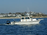
 Rafael |
Andrews, B.D., Miselis, J.L., Danforth, W.W., Irwin, B.J., Worley, C.R., Bergeron, E.M., and Blackwood, D.S., 2015, Marine geophysical data collected in a shallow back-barrier estuary, Barnegat Bay, New Jersey (ver. 1.1, September 2016): U.S. Geological Survey Data Series 937, 15 p., https://doi.org/10.3133/ds937.
Andrews, B.D., Defne, Z., Miselis, J.L., and Ganju, N.K., 2015, Continuous terrain model for water circulation studies, Barnegat Bay, New Jersey, U. S. Geological Survey data release, https://doi.org/10.5066/F7PK0D6B.
Defne, Z., and Ganju, N.K., 2014, Quantifying the residence time and flushing characteristics of a shallow, back-barrier estuary—Application of hydrodynamic and particle tracking models: Estuaries and Coasts, vol. 38, p. 1719-1734, http://dx.doi.org/10.1007/s12237-014-9885-3.
| Survey Equipment | Survey Info | Data Type(s) | Data Collected |
|---|---|---|---|
| SEA SWATHplus-H 468 kHz | --- | Interferometric | |
| Klein 3000 | --- | Sidescan | |
| EdgeTech 424 chirp sub-bottom profiler | --- | Sub Bottom Profiler | |
| HYPACK | --- | Navigation | |
| Sensor - MVP30 (Odim) | --- | Sound Velocity |