Other ID: none
Status: Completed
Organization(s): USGS, Woods Hole Coastal and Marine Science Center
Funding Program(s):
Principal Investigator(s): David Foster
Affiliate Investigator(s): Chris Sherwood
Information Specialist(s): Seth Ackerman
Data Type(s): Sonar: Interferometric, Sonar: Multibeam, Sampling: Geology, Location-Elevation: Navigation, Seismics: Sub Bottom Profiler, Imagery: Photo, Imagery: Video
Scientific Purpose/Goals: Map the CT River from the river mouth north towards Essex, CT; geophysical mapping will be followed by sampling
Vehicle(s):
Start Port/Location: Old Saybrook, CT
End Port/Location: Old Saybrook, CT
Start Date: 2012-09-15
End Date: 2012-09-23
Equipment Used: SeaBOSS, Camera - B/W video, SEA SWATHplus-M 234 kHz, DGPS, EdgeTech 424 chirp sub-bottom profiler, GoPro camera, Real Time Kinematic GPS
Information to be Derived: Grain size analysis;Sea floor map;Bathymetric maps;
Summary of Activity and Data Gathered: About 227 line-km of digital Chirp sub bottom and 234 kHz interferometric sonar data were collected. 100 percent bathymetric coverage was achieved and sonar backscatter were processed and mosaicked in the field. Eighty seven sample stations were occupied, 73 grab samples were collected, 66 stations included video and photographs of the bottom.
Staff: Seth Ackerman, Dann Blackwood, David Foster, Barry Irwin, Eric Moore
Affiliate Staff:
Notes: Project = Sed Processes: Models & Measure,
Information from Foghorn: Edgetech 424 Chirp; video; GoPro camera
Location:
Connecticut River, Old Saybrook, Essex, Connecticut, United States, North America
| Boundaries | |||
|---|---|---|---|
| North: 41.39 | South: 41.239 | West: -72.415 | East: -72.333 |
Platform(s):
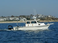
 Rafael |
Ackerman, S.D., Foster, D.S., Moore, E.M., Irwin, B.J., Blackwood, D., and Sherwood, C.R., 2017, High-resolution geophysical and sampling data collected at the mouth of Connecticut River, Old Saybrook to Essex, Connecticut, 2012, USGS Field Activity 2012-024-FA : U.S. Geological Survey data release. https://doi.org/10.5066/F7PG1Q7V.
FAN 2012-024-FA has data viewable in the CMGP Video and Photograph Portal. View the data in this application here. See the instructions for working with this application.
| Title | Survey Equipment | Description |
|---|---|---|
| Cruise log | (document not focused on specific equipment) | Logbook of notes from data acquisition maintained by the USGS science and technical staff in the Connecticut River in 2012 during the field activity 2012-024-FA (PDF – scan of an Excel spreadsheet). |
| Survey Equipment | Survey Info | Data Type(s) | Data Collected |
|---|---|---|---|
| SeaBOSS | --- | Surveys (biological) Experiments (biological) Species ID Photo Video Geology Biology | 2012-024-FA_SamplingNav (Text files of the navigation logged with during the sampling survey of field activity 2012-024-FA in 2012 by the U.S. Geological Survey in the Connecticut River) 2012-024-FA_samples (Location and analysis of sediment samples collected in 2012 by the U.S. Geological Survey in the Connecticut River during field activity 2012-024-FA (point shapefile)) |
| Camera - B/W video | black and white dropcam video camera | Video | 2012-024-FA_SEABOSSvideos (Location of sea floor videos along with videos collected in 2012 by the U.S. Geological Survey in the Connecticut River during field activity 2012-024-FA (polyline shapefile and mp4 videos files)) |
| SEA SWATHplus-M 234 kHz | --- | Interferometric | 2012-024-FA_Backscatter1m (1-meter backscatter imagery collected in 2012 by the U.S. Geological Survey in the Connecticut River during field activity 2012-024-FA (GeoTIFF image)) 2012-024-FA_Bathymetry2m_NAVD88 (2-meter bathymetric data collected in 2012 by the U.S. Geological Survey in the Connecticut River during field activity 2012-024-FA (bathymetry and depth-colored hillshade relief GeoTIFFs)) 2012-024-FA_SWATHPlusTracklines (Survey lines along which swath sonar (bathymetric and backscatter) data were collected in 2012 by the U.S. Geological Survey in the Connecticut River during field activity 2012-024-FA (Polyline Shapefile)) |
| DGPS | --- | Navigation | |
| EdgeTech 424 chirp sub-bottom profiler | --- | Sub Bottom Profiler | 2012-024-FA_SeismicImages (PNG images of each chirp seismic profile collected in 2012 by the U.S. Geological Survey in the Connecticut River during field activity 2012-024-FA) 2012-024-FA_SeismicShot500 (Shotpoint navigation at a 500-shot interval for chirp seismic-reflection data collected in 2012 by the U.S. Geological Survey in the Connecticut River during field activity 2012-024-FA (Point Shapefile)) 2012-024-FA_SeismicTracklines (Survey lines along which seismic reflection data were collected in 2012 by the U.S. Geological Survey in the Connecticut River during field activity 2012-024-FA (Polyline Shapefile)) |
| GoPro camera | --- | Photo Video | 2012-024-FA_SEABOSSphotos (Location of bottom photographs along with images collected in 2012 by the U.S. Geological Survey in the Connecticut River during field activity 2012-024-FA (point shapefile and JPEG images)) |
| Real Time Kinematic GPS | --- | Navigation | 2012-024-FA_HYPACK (Text files of the navigation logged with HYPACK Software during field activity 2012-024-FA in 2012 by the U.S. Geological Survey in the Connecticut River) |