Other ID: none
Status: Completed
Organization(s): USGS, Woods Hole Coastal and Marine Science Center
Funding Program(s):
Principal Investigator(s): Uri Ten Brink
Affiliate Investigator(s): Jeff McGuire, WHOI
Information Specialist(s): Uri Ten Brink
Data Type(s): Seismics: Ocean Bottom Seismometer, Location-Elevation: Navigation
Scientific Purpose/Goals: Deploy ocean bottom seismometers to record shear wave velocity of shallow sediments
Vehicle(s):
Start Port/Location: Woods Hole
End Port/Location: Woods Hole
Start Date: 2012-07-06
End Date: 2012-07-08
Equipment Used: Ocean Bottom Seismometer, DGPS
Information to be Derived:
Summary of Activity and Data Gathered: 12 OBS deployed as planned. Will be picked up in October at which point data will be offloaded
Staff:
Affiliate Staff:
Tim Kane
Dan Kot
Notes: Data will be curated by WHOI and sent to IRIS-DMC, as is done with all OBS data.
I put myself as data curator because one cannot submit without it. Please don't bug me.
Project = Marine Tech/Sea Floor Mapping,
Location:
Georges Bank, United States, North America, North Atlantic;, Southern New England, United States, North America, North Atlantic
| Boundaries | |||
|---|---|---|---|
| North: 39.9 | South: 39.8 | West: -71 | East: -70.9 |
Platform(s):
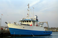
 Connecticut |
Flores, C.H., ten Brink, U.S., McGuire, J.J, and Collins, J.A., 2017, Observations of seismicity and ground motion in the Northeast U.S. Atlantic margin from ocean-bottom seismometer data: Seismological Research Letters, 88(1), p.23-31, https://doi.org/10.1785/0220160079.
Flores, C.H., ten Brink, U.S., McGuire, J.J., and Collins, J.A., Seismicity and attenuation of the continental margin off New York and New England from OBS data [abs.]: , 2014 AGU Fall Meeting.
| Survey Equipment | Survey Info | Data Type(s) | Data Collected |
|---|---|---|---|
| Ocean Bottom Seismometer | --- | Ocean Bottom Seismometer | 2012-031-FA-SE-001 (Ocean Bottom Seismometer (OBS) data. Instruments were deployed under this field activity number. OBS were retrieved under field activity number 2012-050-FA. (Nov. 29, 2012 - Dec. 2, 2012) Please refer to retrieval field activity number for more information concerning data.) |
| DGPS | --- | Navigation |