Other ID: none
Status: Completed
Organization(s): USGS, Woods Hole Coastal and Marine Science Center
Funding Program(s):
Principal Investigator(s): Bradford Butman
Affiliate Investigator(s):
Information Specialist(s): Bradford Butman
Data Type(s): Sampling: Geology, Imagery: Video
Scientific Purpose/Goals: Test video camera and lights on WHOI Craib corer.
Vehicle(s):
Start Port/Location: Woods Hole, MA
End Port/Location: Woods Hole, MA
Start Date: 2012-09-25
End Date: 2012-09-25
Equipment Used: Craib corer, Video camera - deep sea
Information to be Derived: Laboratory sensor data;
Summary of Activity and Data Gathered: This cruise tested various light configurations for an underwater video mounted on WHOI Craib corer. No data are archived from this activity. The system was tested outside of Hadley's Harbor, and in Buzzards Bay. There was too much light at the Hadley's location and too much suspended material in Buzzards Bay. The system was successfully tested following the cruise in the well at the WHOI dock.
Staff: Sandy Baldwin, Patrick Dickhudt, Adrian Green
Affiliate Staff:
Bruce Keafer
Woods Hole Oceanographic Institution
Notes:
Project = Library of Sea-Floor Photograp,
Location:
Buzzards Bay, Cape Cod, Massachusetts, United States, North America, North Atlantic;,
| Boundaries | |||
|---|---|---|---|
| North: 41.6 | South: 41.5 | West: -70.9 | East: -70.65 |
Platform(s):
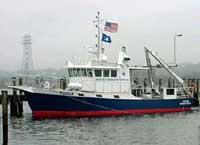
 Tioga |
| Survey Equipment | Survey Info | Data Type(s) | Data Collected |
|---|---|---|---|
| Craib corer | --- | Geology | |
| Video camera - deep sea | --- | Video |