Other ID: none
Status: Completed
Organization(s): USGS, Woods Hole Coastal and Marine Science Center
Funding Program(s): NSF Bottom Stress (LQ00DYN)
Principal Investigator(s): Christopher Sherwood
Affiliate Investigator(s):
Information Specialist(s): Patrick Dickhudt
Data Type(s): Location-Elevation: Navigation, Sampling: Geology, Time Series: Mooring (physical oceanography)
Scientific Purpose/Goals: Deploy bottom platforms and NIMBBLEs for NSF Inner Shelf Study
Vehicle(s):
Start Port/Location: Woods Hole, MA
End Port/Location: Woods Hole, MA
Start Date: 2014-06-30
End Date: 2014-07-02
Equipment Used: Bottom platform, DGPS, Grab sampler
Information to be Derived: Bottom stress
Summary of Activity and Data Gathered: Sediment samples, geophysics, and tripod monitoring
Staff: Seth Ackerman, Emile Bergeron, Jonathan Borden, Patrick Dickhudt, Marinna Martini, Ellyn Montgomery, Christopher Sherwood
Affiliate Staff:
Notes: first deployment cruise- also see 2014-025-FA, 2014-026-FA, 2014-050-FA, 2014-052-FA, 2014-059-FA, 2014-068-FA.
Location:
Martha's Vineyard Coastal Observatory, Massachusetts
| Boundaries | |||
|---|---|---|---|
| North: 41.3564774 | South: 41.25294098 | West: -70.7865 | East: -70.3989094 |
Platform(s):
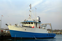
 Connecticut |
Montgomery, E.T., Sherwood, C.R., Martini, M.A., Trowbridge, J., Scully, M., and Brosnahan, S.M., 2016, Oceanographic and water-quality measurements collected south of Martha's Vineyard, MA, 2014–2015: U.S. Geological Survey data release, https://doi.org/10.5066/F7542KQR.
Scully, M.E., Trowbridge, J.H., Sherwood, C.R., Jones, K.R., and Traykovski, P., 2018, Direct measurements of mean Reynolds stress and ripple roughness in the presence of energetic forcing by surface waves: Journal of Geophysical Research - Oceans, v. 123, p. 2494-2512, https://doi.org/10.1002/2017JC013252.
Trowbridge, J., Scully, M., Sherwood, C.R., 2018, The cospectrum of stress-carrying turbulence in the presence of surface gravity waves: Journal of Physical Oceanography, v. 48, issue 1, p. 29-44, https://doi.org/10.1175/JPO-D-17-0016.1.
| Survey Equipment | Survey Info | Data Type(s) | Data Collected |
|---|---|---|---|
| Bottom platform | --- | Mooring (physical oceanography) | MVCO_14 timeseries (Data from all platforms. There were 2 deployements fo each platform) |
| DGPS | --- | Navigation | |
| Grab sampler | --- | Biology Geology |