AKA: H-6-09-AR, 2009-006-FA, 09006, H0609AR, H-06-09-AR
Other ID: HLY0905
Status: Completed
Organization(s): USGS, Pacific Coastal and Marine Science Center, USGS, Woods Hole Coastal and Marine Science Center
Funding Program(s): Law of the Sea - Outer Limits of the US continental Margins ()
Principal Investigator(s): Helen Beikman
Affiliate Investigator(s): Debbie Hutchinson, David Mosher
Information Specialist(s):
Data Type(s): Sampling: Geology
Scientific Purpose/Goals: Multibeam and Chirp mapping of the sea floor of potential U.S. extended continental shelf in the Arctic Ocean north of Alaska.
Vehicle(s): None
Start Port/Location: Barrow, AK
End Port/Location: Barrow, AK
Start Date: 2009-08-07
End Date: 2009-09-16
Equipment Used: dredge
Information to be Derived: Notes/logs;Bathymetry;Sonar;CTD and other measurements to estimate velocity of sound in the water column
Summary of Activity and Data Gathered:
Staff:
Affiliate Staff:
Notes: FACS ID created from InfoBank website
07/03/2012, update:
Cruise report for Healy 2009 can be found at these two locations -
http://ccom.unh.edu/sites/default/files/publications/Mayer 2009 cruise report
HE0905.pdf
and
http://www.ngdc.noaa.gov/mgg/curator/data/healy/hly0905/HE0905cruisereport.pdf.
All ECS cruises are cataloged with extensive statistics and metadata at this
NGDC ECS portal -
http://www.ngdc.noaa.gov/mgg/ecs/cruises.html.
General descriptive material and blogs (click on "Missions" to see list of
cruises conducted with links to more info) are at -
http://continentalshelf.gov.
This Coast Guard site includes outreach type material from the ship -
http://www.uscg.mil/pacarea/cgchealy/aws09/.
08/03/2009, report note:
Cruise is currently devoted 100 % to two-icebreaker work, but
this could be reduced depending on planning to take place in
January. There is also a slight chance that there could be dredging
(possibly using a USGS dredge from MP).
Cruise is currently devoted 100% to two-icebreaker work.
18. Report Date:
11:33 8/3/2009
Location:
Arctic Ocean
| Boundaries | |||
|---|---|---|---|
| North: 81.17954633 | South: 70.99596114 | West: -161.71875 | East: -125.4296875 |
Platform(s):
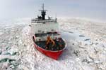 Healy |
| Survey Equipment | Survey Info | Data Type(s) | Data Collected |
|---|---|---|---|
| dredge | --- | Geology |
