AKA: none
Other ID: L-11-11-BS,MGL1111
Status: Completed
Organization(s): National Oceanic and Atmospheric Administration, Bureau of Ocean Energy Management, University of Wyoming, USGS, Pacific Coastal and Marine Science Center
Funding Program(s):
Principal Investigator(s): Ginger Barth
Affiliate Investigator(s): Warren Wood
Information Specialist(s):
Data Type(s): Electro-Magnetic: Gravity, Environmental Data: CTD, Location-Elevation: Navigation, Seismics: Multichannel, Seismics: Ocean Bottom Seismometer, Seismics: Sonobuoy, Sonar: Multibeam
Scientific Purpose/Goals: sediment thickness, velocity structure and sedimentary architecture for Law of the Sea
Vehicle(s):
Start Port/Location: Dutch Harbor, AK
End Port/Location: Dutch Harbor, AK
Start Date: 2011-08-06
End Date: 2011-09-01
Equipment Used: gravity, GPS, Multichannel, multibeam, CTD
Information to be Derived:
Summary of Activity and Data Gathered:
Staff: Ginger Barth, David Scholl, Ray Sliter, Peter Triezenberg, Jennifer White
Affiliate Staff:
Tom O'Brien
Warren Wood - NRL
Jennifer Henderson (NGDC) - OAA
Jorden Hayes - U Wyoming
Notes: AKA MGL11-11 2011 Bering Sea, U.S. Extended Continental Shelf Project, http://continentalshelf.gov/missions/11missions/11bering.html
Staff information imported from InfoBank
Ginger Barth
Dave Scholl
Peter Triezenberg
Tom O'Brien
Wayne Baldwin
Nina Ivanova
Jenny White
Warren Wood - NRL
Jennifer Henderson (NGDC) - OAA
Jorden Hayes - U Wyoming
Location:
Aleutian Basin of the central Bering Sea
| Boundaries | |||
|---|---|---|---|
| North: 60.11548266 | South: 53.89318 | West: -179.1109 | East: -166.47903 |
Platform(s):
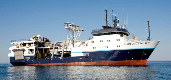 Marcus G. Langseth |
Barth, G.A., Baldwin, W.E., Reece, R.S., Gulick, S.S., Danforth, W.W., and Wong, F.L., 2022, Multibeam bathymetry and acoustic backscatter from the Alaskan region, Extended Continental Shelf Project, 2011 field season: Gulf of Alaska and Bering Sea: U.S. Geological Survey data release, https://doi.org/10.5066/F7HM56HK.
FAN l1111bs has data viewable in the GeoMappApp/Virtual Ocean applications. To view this data in these applications go to http://www.geomapapp.org/ and http://www.virtualocean.org/. See the instructions for locating USGS data in these applications. You can also view the imagery created from the SEGY data at https://cmgds.marine.usgs.gov/images.php?cruise=l1111bs.
| Survey Equipment | Survey Info | Data Type(s) | Data Collected |
|---|---|---|---|
| gravity | --- | Gravity | |
| GPS | --- | Navigation | Best file with nav in ArcInfo E00 format Global positioning system (GPS) data l-11-11-bs.060 Integrated navigation (SINS) data l-11-11-bs.050 Global positioning system (GPS) data l-11-11-bs.061 (Provisional best file) |
| Multichannel | --- | Multichannel | Seismic FFID/Shot/CDP data l-11-11-bs.410_mcs (Provisional best file) |
| multibeam | --- | Multibeam | Raw depth (bathymetry) data l-11-11-bs.300_060 (Provisional best file) MGL1111backsutm.sd (Multibeam backscatter data collected by the U.S. Geological Survey in the Bering Sea in 2011 during cruise MGL1111, 100-meter gridded data in Fledermaus digital terrain format, UTM zone 60 coordinates) MGL1111backsgeo.sd (Multibeam backscatter data collected by the U.S. Geological Survey in the Bering Sea in 2011 during cruise MGL1111, 100-meter gridded data in Fledermaus digital terrain format, geographic coordinate system) MGL1111backsgeo.asc (Multibeam backscatter data collected by the U.S. Geological Survey in the Bering Sea in 2011 during cruise MGL1111, 100-meter gridded data in Esri gridascii format, geographic coordinate system) MGL1111backsutm.asc (Multibeam backscatter data collected by the U.S. Geological Survey in the Bering Sea in 2011 during cruise MGL1111, 100-meter gridded data in Esri gridascii export format, UTM zone 60 coordinates) MGL1111backsgeo.xyb (Multibeam backscatter data collected by the U.S. Geological Survey in the Bering Sea in 2011 during cruise MGL1111, 100-meter gridded data in longitude, latitude, backscatter (decibel) format, geographic coordinate system) MGL1111bathygeo.asc (Multibeam bathymetry data collected by the U.S. Geological Survey in the Bering Sea in 2011 during cruise MGL1111, 100-meter gridded data in Esri gridascii format, geographic (latitude, longitude) coordinates) MGL1111bathygeo.sd (Multibeam bathymetry data collected by the U.S. Geological Survey in the Bering Sea in 2011 during cruise MGL1111, 100-meter gridded data in Fledermaus digital terrain format, geographic (latitude, longitude) coordinates) MGL1111bathygeo.xyz (Multibeam bathymetry data collected by the U.S. Geological Survey in the Bering Sea in 2011 during cruise MGL1111, 100-meter gridded data in longitude, latitude, depth (meters) format, geographic (latitude, longitude) coordinates) MGL1111bathyutm.bag (Multibeam bathymetry data collected by the U.S. Geological Survey in the Bering Sea in 2011 during cruise MGL1111, 100-meter gridded data in bathymetric attributed grid format, UTM coordinate system) MGL1111bathyutm.sd (Multibeam bathymetry data collected by the U.S. Geological Survey in the Bering Sea in 2011 during cruise MGL1111, 100-meter gridded data in Fledermaus digital terrain format, UTM coordinate system) MGL1111centerdepth.shp (Multibeam bathymetry data collected by the U.S. Geological Survey in the Bering Sea in 2011 during cruise MGL1111, along-track center-beam depths extracted from 100-meter gridded data in shapefile format, geographic coordinates) MGL1111shadeutm.tif (Multibeam bathymetry data collected by the U.S. Geological Survey in the Bering Sea in 2011 during cruise MGL1111, 100-meter gridded shaded bathymetric relief in GeoTIFF format) Multibeam bathymetry data (Multibeam bathymetry data collected by the U.S. Geological Survey in the Bering Sea in 2011 during cruise MGL1111, along-track center-beam depths extracted from 100-meter gridded data in plain text format, geographic coordinates. This shapefile contains center-beam depths for approximately 5727 trackline kilometers of Simrad EM122 multibeam-bathymetry data collected in the Bering Sea during U.S. Geological Survey - Coastal and Marine Geology Program cruise MGL1111 aboard the R/V Marcus G. Langseth. The depth values were extracted from gridded data which were reduced for position, elevation, orientation, water-column sound-speed, and refraction effects.) MGL1111backsutm.xyb (Multibeam backscatter data collected by the U.S. Geological Survey in the Bering Sea in 2011 during cruise MGL1111, 100-meter gridded data in x, y, and backscatter (decibel) format, UTM zone 60 coordinates) MGL1111bathygeo.tif (Multibeam bathymetry data collected by the U.S. Geological Survey in the Bering Sea in 2011 during cruise MGL1111, 100-meter gridded data in GeoTIFF format, geographic (latitude, longitude) coordinates) MGL1111bathyutm.tif (Multibeam bathymetry data collected by the U.S. Geological Survey in the Bering Sea in 2011 during cruise MGL1111, 100-meter gridded data in GeoTIFF format, UTM coordinate system) MGL1111bathyutm.asc (Multibeam bathymetry data collected by the U.S. Geological Survey in the Bering Sea in 2011 during cruise MGL1111, 100-meter gridded data in Esri gridascii export format, UTM coordinate system) MGL1111backsutm.tif (Multibeam backscatter data collected by the U.S. Geological Survey in the Bering Sea in 2011 during cruise MGL1111, 100-meter gridded data in GeoTIFF format, UTM zone 60 coordinates) |
| CTD | --- | Surveys (geochemical) Experiments (geochemical) CTD |
