AKA: 2016 Santa Barbara Basin Geophysical Survey
Other ID: none
Status: Completed
Organization(s): USGS, Pacific Coastal and Marine Science Center
Funding Program(s): Coastal and marine earthquake, tsunami, and landslide active margin field studies (ZP00EQV)
Principal Investigator(s): Jared Kluesner
Affiliate Investigator(s):
Information Specialist(s): Peter Dartnell, Ray Sliter
Data Type(s): Location-Elevation: Navigation, Seismics: Multichannel, Seismics: Sparker, Sonar: Multibeam, Sonar: Sound Velocity
Scientific Purpose/Goals: Investigate the causes and consequences of submarine landslides in the Santa Barbara Basin using state-of-the-art geophysical methods
Vehicle(s): Dodge Caravan - G41-2395R
Start Port/Location: Santa Barbara, CA
End Port/Location: Santa Barbara, CA
Start Date: 2016-09-10
End Date: 2016-10-05
Equipment Used: Other, Mini sparker, GPS, multichannel, Reson 7111, AML SV Plus
Information to be Derived: high-res multibeam bathymetry, seafloor backscatter, water column backscatter, seismic profiles
Summary of Activity and Data Gathered: post processed data submitted 3/1/2017 water column backscatter data added 1/24/2017 GIS, POS_PAC, Reports, Reson_711, seismic, SVP and Tides Data submitted to FAD 11/09/2016 The Pacific Coastal and Marine Science Center of the U.S Geological Survey (USGS) conducted a geophysical survey collecting bathymetry, acoustic-backscatter, and sparker multi-channel seismic reflection data in the Santa Barbara Channel. The work was conducted aboard the 36-foot USGS R/V Parke Snavely and aboard the Channel Islands National Marine Sanctuary's 62-foot R/V Shearwater out of the Santa Barbara harbor.
Staff: Jackson Currie, Peter Dal Ferro, Peter Dartnell, Gerry Hatcher, Daniel Powers, Robert Wyland
Affiliate Staff:
Notes: multiplatform survey (snavely and shearwater) with multiple targets and phases of operation
Location:
Santa Barbara Basin
| Boundaries | |||
|---|---|---|---|
| North: 34.81380332 | South: 33.74936476 | West: -120.85 | East: -119.05761719 |
Platform(s):
 Parke Snavely | 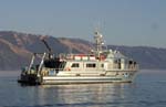 Shearwater |
Balster-Gee, A.F., Kluesner, J.W., Brothers, D.S., Dartnell, P., Wright, A.L., and Edwards, J.H., 2020, Multibeam bathymetry, acoustic backscatter, and multichannel minisparker seismic-reflection data of USGS field activity 2016-666-FA collected in the Santa Barbara Basin in September and October of 2016: U.S. Geological Survey data release, https://doi.org/10.5066/P9W449LP.
| Survey Equipment | Survey Info | Data Type(s) | Data Collected |
|---|---|---|---|
| Other | --- | --- | --- |
| Mini sparker | --- | Sparker | |
| GPS | --- | Navigation | |
| multichannel | --- | Multichannel | Acoustic-backscatter data (These metadata describe acoustic-backscatter data collected during an October 2016 multibeam-echosounder survey of the northern portion of the Santa Barbara Channel, California. Data were collected and processed by the U.S. Geological Survey (USGS), Pacific Coastal and Marine Science Center (PCMSC) with fieldwork activity number 2016-666-FA. The acoustic-backscatter data are provided as a GeoTIFF image.) Multibeam bathymetry data (These metadata describe bathymetry data collected during an October 2016 multibeam-echosounder survey of the northern portion of the Santa Barbara Channel, California. Data were collected and processed by the U.S. Geological Survey (USGS), Pacific Coastal and Marine Science Center (PCMSC) with fieldwork activity number 2016-666-FA. The bathymetry data are provided as a GeoTIFF image.) Multichannel minisparker seismic-reflection data (High-resolution multichannel minkisparker seismic-reflection (MCS) profiles were collected by the U.S. Geological Survey in September and October of 2016 from the northern portion of the Santa Barbara Basin offshore southern California. Data were collected aboard the USGS R/V Parke Snavely and NOAA R/V Shearwater during field activity 2016-666-FA using a SIG 2-mille minisparker and recorded using 48- or 24-channel Geometrics digital hydrophone streamer. Sub-bottom acoustic penetration spans several hundreds of meters and is variable by location.) |
| Reson 7111 | --- | Multibeam | |
| AML SV Plus | --- | Sound Velocity |
