AKA: none
Other ID: none
Status: Completed
Organization(s): USGS, Pacific Coastal and Marine Science Center
Funding Program(s): Climate Change Impacts to the U.S. Pacific and Arctic Coasts (ZP00F00)
Principal Investigator(s): Patrick Barnard
Affiliate Investigator(s):
Information Specialist(s): Alexander Snyder, Andrew Stevens
Data Type(s): Imagery: Photo, Location-Elevation: LIDAR, Location-Elevation: Navigation, Location-Elevation: Profiles, Sonar: Single Beam, Sonar: Sound Velocity
Scientific Purpose/Goals: Collect nearshore bathymetry and beach topography in Monterey Bay
Vehicle(s): Explorer G62-2733K, MarFac; Chevy Suburban - gray; 7 pass; G62-2874L, MarFac; Expedition G62-3094P, MarFac; Ford F350 pickup/stake truck; 6 pass; G82-0317H
Start Port/Location: Santa Cruz, CA
End Port/Location: Moss Landing, CA
Start Date: 2017-09-18
End Date: 2017-09-22
Equipment Used: Waverunners, Trimble R7 GPS receiver 9, camera, Trimble R7 GPS (AS), YSI Sound velocity CTD, Structure from Motion - crewed aircraft, Trimble R10 GPS (AS), Trimble R7 GPS receiver
Information to be Derived: Nearshore bathymetry, beach topography
Summary of Activity and Data Gathered: Structure from motion photos added by Josh Logan 3/5/2018 base, bathy, field_notes, grids, matlab, photos, planning, svp, tls, and topo data have been added to FAD on 2/6/2018; Andrew Stevens
Staff: Patrick Barnard, Jackson Currie, Timothy Elfers, Stephen Hartwell, Daniel Hoover, SeanPaul La Selle, Joshua Logan, Alexander Snyder, Andrew Stevens, Jonathan Warrick
Affiliate Staff:
Notes: Local Fieldwork, NO OT
Entries for this field activity are based on entries from Field Activity 2016-627-FA
Entries for this field activity are based on entries from Field Activity 2016-674-FA
Entries for this field activity are based on entries from Field Activity 2017-620-FA
Location:
Monterey Bay
| Boundaries | |||
|---|---|---|---|
| North: 36.99816566 | South: 36.80973309 | West: -122.097 | East: -121.75476074 |
Platform(s):
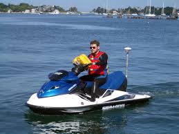
 Waverunner 1 (SC) |  Waverunner 2 (SC) |
Snyder, A.G., Stevens, A.W., Logan, J.B., and Hoover, D.J., 2024, Digital elevation models (DEMs) of the beach and nearshore in Santa Cruz, California: U.S. Geological Survey data release, https://doi.org/10.5066/P134BC6W.
Stevens, A.W., Logan, J.B., Snyder, A.G., Hoover, D.J., Barnard, P.L., and Warrick, J.A., 2017, Beach topography and nearshore bathymetry of northern Monterey Bay, California: U.S. Geological Survey data release.
| Survey Equipment | Survey Info | Data Type(s) | Data Collected |
|---|---|---|---|
| Waverunners | --- | Navigation Single Beam | Digital elevation models (DEMs) of northern Monterey Bay, California, September 2017 (This part of the data release presents digital elevation models (DEMs) derived from bathymetry and topography data of northern Monterey Bay, California collected in September 2017. Bathymetry data were collected using two personal watercraft (PWCs), each equipped with single-beam echosounders and survey-grade global navigation satellite system (GNSS) receivers. Topography data were collected on foot with GNSS receivers mounted on backpacks and with an all-terrain vehicle (ATV) using a GNSS receiver mounted at a measured height above the ground. Additional topography data were collected with a terrestrial lidar scanner. DEM surfaces were produced from all available elevation data using linear interpolation.) Nearshore bathymetry data from northern Monterey Bay, California, September 2017 (This part of the data release presents bathymetry data from northern Monterey Bay, California collected in September 2017 using two personal watercraft (PWCs). The PWCs were equipped with single-beam echosounders and survey-grade global navigation satellite system (GNSS) receivers.) |
| Trimble R7 GPS receiver 9 | --- | Benchmarks LIDAR Navigation Profiles Transects | Terrestrial lidar data from northern Monterey Bay, California, September 2017 (This part of the data release presents topography data from northern Monterey Bay, California collected in September 2017 with a terrestrial lidar scanner.) |
| camera | --- | Photo | |
| Trimble R7 GPS (AS) | --- | Benchmarks Navigation Profiles Transects | Topography data from northern Monterey Bay, California, September 2017 (This part of the data release presents topography data from northern Monterey Bay, California collected in September 2017. Topography data were collected on foot with survey-grade global navigation satellite system (GNSS) receivers mounted on backpacks and with an all-terrain vehicle (ATV) using a GNSS receiver mounted at a measured height above the ground.) |
| YSI Sound velocity CTD | --- | Sound Velocity | |
| Structure from Motion - crewed aircraft | --- | Photo | |
| Trimble R10 GPS (AS) | --- | Navigation Profiles | |
| Trimble R7 GPS receiver | --- | Benchmarks LIDAR Navigation Profiles Transects |