Other ID: 2019-314-FA (Kellog St. Pete), RB-19-03 (NOAA) , WHOI JASON ROV, 2019-620-FA (Prouty, SC)
Status: Completed
Organization(s): National Oceanic and Atmospheric Administration, Woods Hole Oceanographic Institution, USGS, St. Petersburg Coastal and Marine Science Center, USGS, Pacific Coastal and Marine Science Center, USGS, Woods Hole Coastal and Marine Science Center
Funding Program(s): Deepwater Atlantic Habitats II: Continued Atlantic Research and Exploration in Deepwater Ecosystems with Focus on Coral, Canyon, and Seep Communities (GX.17LQ00.FFV85.00)
Principal Investigator(s): Jason Chaytor
Affiliate Investigator(s):
Information Specialist(s): Brian Andrews, Brian Buczkowski
Data Type(s): Environmental Data: CTD, Imagery: Photo, Imagery: Video, Location-Elevation: Navigation, Sampling: Biology, Sampling: Chemistry, Sampling: Geology, Seismics: Sub Bottom Profiler, Sonar: Multibeam, Sonar: Sound Velocity
Scientific Purpose/Goals: Seafloor characterization of seeps, canyons and reefs
Vehicle(s):
Start Port/Location: Charleston, SC
End Port/Location: Charleston, SC
Start Date: 2019-04-01
End Date: 2019-04-30
Equipment Used: EM122 12 kHz multibeam, CTD 19+ with OBS, PAR, DO, Chl, ROV, DGPS, Push corer (wh), Niskin bottle, Other, Knudsen 3260, Other
Information to be Derived: Grain size, carbonate content, sediment age, rock types
Summary of Activity and Data Gathered: Covered 4,167 kilometers over 22 days at sea in depths of 135-3,175 meters. Collected 1,821 linear kilometers (6,733 square kilometers) of EM122 multibeam bathymetry and backscatter. Collected 89 files of EM122 water column data over 6 days.Collected 1,270 kms of seismic profile data. 11 ROV JASON (WHOI) Dives, 18 CTDs and deployed 2 Landers. Each ROV dive has video, photos, and numerous physical and bilogical samples. Physical samples are being processed by USGS Woods Hole Sediment Lab and will be logged here once when processing is complete.
Staff: Brian Andrews
Affiliate Staff:
Notes: Additional USGS Crew:
Amanda Demopoulos (Chief Scientist Leg 1)
Chris Kellogg
Jennifer Counts
Cheryl Morrison
Nancy Prouty
Aaron Aunins
Allyson Boggess
Jill Bourque
Jonathan Quigley
Leg 1 8-16 Apr 19
Leg 2 16-30 Apr 19
NOTE: There are 3 separate USGS Field Activities for each of the 3 CMGP centers involved in this survey:
2019-003-FA Woods Hole, MA (Chaytor)
2019-314-FA St. Petersburg, FL (Kellog)
https://cmgds.marine.usgs.gov/fan_info.php?fan=2019-314-FA
2019-620-FA Santa Cruz, CA (Prouty)
https://cmgds.marine.usgs.gov/fan_info.php?fan=2019-620-FA
NOAA Survey ID for this survey is RB-19-03
Location:
South Atlantic Bight; offshore NC, GA and FL
| Boundaries | |||
|---|---|---|---|
| North: 35.94 | South: 31.24 | West: -79.946 | East: -74.777 |
Platform(s):
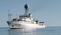 Ronald H. Brown | 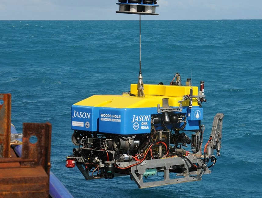 ROV Jason |
Prouty, N.G., and Chaytor, J.D., 2022, Carbonate chemistry measurements of authigenic carbonates collected offshore the U.S. Mid- and South Atlantic in 2018 and 2019 as part of the DEEPSEARCH Project: U.S. Geological Survey data release, https://doi.org/10.5066/P9DRU8TP.
| Survey Equipment | Survey Info | Data Type(s) | Data Collected |
|---|---|---|---|
| EM122 12 kHz multibeam | --- | Multibeam | |
| CTD 19+ with OBS, PAR, DO, Chl | --- | CTD | |
| ROV | --- | Photo Video Biology Geology | |
| DGPS | --- | Navigation | |
| Push corer (wh) | --- | Biology Geology | |
| Niskin bottle | --- | Chemistry | |
| Other | --- | --- | --- |
| Knudsen 3260 | --- | Sub Bottom Profiler | |
| Other | --- | --- | --- |
