Citation:
Citation_Information:
Originator: Jane A. Reid
Originator: Jamey M. Reid
Originator: Chris J. Jenkins
Originator: Mark Zimmermann
Originator: S. Jeffress Williams
Originator: Michael E. Field
Publication_Date: 2006
Title:
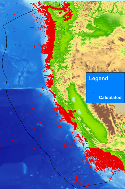
PAC_CLC: Calculated seabed data for the continental margin of the U.S. Pacific Coast (California, Oregon, Washington) from usSEABED (pac_clc.txt)
Edition: 1.0
Geospatial_Data_Presentation_Form: comma-delimited text and vector digital data
Series_Information:
Series_Name: Data Series
Issue_Identification: 182
Publication_Information:
Publication_Place: Pacific Coastal and Marine Science Center, Santa Cruz, CA
Publisher: U.S. Geological Survey, Coastal and Marine Geology Program
Online_Linkage: https://pubs.usgs.gov/ds/2006/182/data/pac_clc.zip
Online_Linkage: https://pubs.usgs.gov/ds/2006/182/data_cata.html
Online_Linkage: https://doi.org/10.3133/ds182
Larger_Work_Citation:
Citation_Information:
Originator: Jane A. Reid
Originator: Jamey M. Reid
Originator: Chris J. Jenkins
Originator: Mark Zimmermann
Originator: S. Jeffress Williams
Originator: Michael E. Field
Publication_Date: 2006
Title:
usSEABED: Pacific Coast Offshore Surficial-Sediment Data Release
Edition: 1.0
Series_Information:
Series_Name: Data Series
Issue_Identification: 182
Publication_Information:
Publication_Place: Pacific Coastal and Marine Science Center, Santa Cruz, CA
Publisher: U.S. Geological Survey, Coastal and Marine Geology Program
Online_Linkage: https://doi.org/10.3133/ds182
Online_Linkage: https://pubs.usgs.gov/ds/2006/182/index.html
Description:
Abstract:
This data layer (PAC_CLC.txt) is one of five point coverages of known sediment samples, inspections, and probes from the usSEABED data collection for the U.S Pacific continental margin integrated using the software system dbSEABED. This data layer represents the calculated (CLC) output of the dbSEABED mining software. Data in this file extend variables determined through the data extraction (EXT) and data parsing (PRS) processes of dbSEABED, calculated using empirical relations or known functions. The CLC data is the most derivative and least accurate of the usSEABED data files and should be used with caution; however, many users may appreciate that it extends the coverage of map areas with attributes, especially physical properties attributes. Please refer to the dbSEABED page (
https://pubs.usgs.gov/ds/2006/182/dbseabed.html), and the Frequently Asked Questions (
https://pubs.usgs.gov/ds/2006/182/faq.html) pages for more information on the calculation process. This file contains the same data fields as the extracted (PAC_EXT) and parsed (PAC_PRS) data files, and the three files may be combined.
To build a digital mapping of the character of the seabed on regional, national and global scales. These data are intended for science researchers, students, policy makers, and the general public. The data can be used with geographic information systems (GIS) software to display geologic and oceanographic information.
Time_Period_of_Content:
Time_Period_Information:
Single_Date/Time:
Calendar_Date: 2006
Currentness_Reference: publication date
Status:
Progress: Planned
Maintenance_and_Update_Frequency: As needed
Spatial_Domain:
Bounding_Coordinates:
West_Bounding_Coordinate: -129.28899
East_Bounding_Coordinate: -117.00678
North_Bounding_Coordinate: 48.99833
South_Bounding_Coordinate: 30.57000
Keywords:
Theme:
Theme_Keyword_Thesaurus: USGS Metadata Identifier
Theme_Keyword: USGS:9c3ed437-7563-4b4b-a4e6-d27348c821f5
Theme:
Theme_Keyword_Thesaurus: ISO 19115 Topic Category
Theme_Keyword: Oceans
Theme_Keyword: Location
Theme_Keyword: GeoscientificInformation
Theme:
Theme_Keyword_Thesaurus: Global Change Master Directory (GCMD)
Theme_Keyword: Marine Sediments
Theme_Keyword: Biogenic Sediments
Theme_Keyword: Sediment Chemistry
Theme_Keyword: Sediment Composition
Theme_Keyword: Sediment Textures
Theme_Keyword: Stratigraphic Sequence
Theme_Keyword: Terrigenous Sediments
Theme:
Theme_Keyword_Thesaurus: Coastal and Marine Ecological Classification Standard (CMECS)
Theme_Keyword: Marine Nearshore
Theme_Keyword: Marine Offshore
Theme_Keyword: Estuarine Coastal
Theme_Keyword: Borderland
Theme_Keyword: Continental/Island Shelf
Theme_Keyword: Continental/Island Slope
Theme_Keyword: Rock Substrate
Theme_Keyword: Unconsolidated Mineral Substrate
Theme:
Theme_Keyword_Thesaurus: Data Categories for Marine Planning
Theme_Keyword: distributions
Theme_Keyword: sand resources
Theme_Keyword: substrate
Theme:
Theme_Keyword_Thesaurus: Marine Realms Information Bank (MRIB) keywords
Theme_Keyword: seabed
Theme_Keyword: sediment resources
Theme_Keyword: sand deposit
Theme:
Theme_Keyword_Thesaurus: USGS Thesaurus
Theme_Keyword: sea-floor characteristics
Theme_Keyword: nonmetallic mineral resources
Theme_Keyword: gravel deposits
Theme_Keyword: sand deposits
Theme_Keyword: geology
Theme_Keyword: unconsolidated deposits
Theme:
Theme_Keyword_Thesaurus: None
Theme_Keyword: Seabed
Theme_Keyword: Sea floor
Theme_Keyword: Sediment
Theme_Keyword: Components
Theme_Keyword: Features
Theme_Keyword: Genesis
Theme_Keyword: Descriptions
Theme_Keyword: Analyses
Theme_Keyword: usSEABED
Theme_Keyword: dbSEABED
Theme_Keyword: U.S. Geological Survey
Theme_Keyword: USGS
Theme_Keyword: Coastal and Marine Geology Program
Theme_Keyword: CMGP
Theme_Keyword: Pacific Coastal and Marine Science Center
Theme_Keyword: PCMSC
Theme_Keyword: Woods Hole Science Center
Theme_Keyword: WHSC
Theme_Keyword: Benthic Habitats (Pacific) Project
Theme_Keyword: Marine Aggregates Resources and Processes Project
Theme_Keyword: University of Colorado
Theme_Keyword: UC
Theme_Keyword: Institute of Arctic and Alpine Research
Theme_Keyword: INSTAAR
Theme_Keyword: National Oceanic and Atmospheric Administration
Theme_Keyword: NOAA
Theme_Keyword: National Marine Fisheries Service
Theme_Keyword: NMFS
Place:
Place_Keyword_Thesaurus: Geographic Names Information System (GNIS)
Place_Keyword: United States of America
Place_Keyword: Pacific Ocean
Place_Keyword: State of California
Place_Keyword: State of Oregon
Place_Keyword: State of Washington
Place_Keyword: Puget Sound
Place_Keyword: Willapa Bay
Place_Keyword: Grays Harbor
Place_Keyword: San Francisco Bay
Place_Keyword: Monterey Bay
Place_Keyword: Santa Monica Bay
Place_Keyword: San Pedro Bay
Place:
Place_Keyword_Thesaurus: None
Place_Keyword: Pacific coast
Place_Keyword: West Coast
Place:
Place_Keyword_Thesaurus: Coastal and Marine Ecological Classification Standard (CMECS)
Place_Keyword: Oregon, Washington, Vancouver Coast and Shelf Ecoregion
Place_Keyword: Northern California Ecoregion
Place_Keyword: Southern California Bight Ecoregion
Stratum:
Stratum_Keyword_Thesaurus: Coastal and Marine Ecological Classification Standard (CMECS)
Stratum_Keyword: Substrate
Access_Constraints: None
Use_Constraints:
USGS-authored or produced data and information are in the public domain from the U.S. Government and are freely redistributable with proper metadata and source attribution. Please recognize and acknowledge the U.S. Geological Survey as the originator(s) of the dataset and in products derived from these data. This information is not intended for navigation purposes.
Point_of_Contact:
Contact_Information:
Contact_Person_Primary:
Contact_Person: Jane A. Reid
Contact_Organization: U.S. Geological Survey
Contact_Position: Geologist
Contact_Address:
Address_Type: mailing and physical address
Address: Pacific Coastal and Marine Science Center
Address: 2885 Mission Street
City: Santa Cruz
State_or_Province: CA
Postal_Code: 95060-5792
Country: USA
Contact_Voice_Telephone: (831) 427-4727
Contact_Electronic_Mail_Address: jareid@usgs.gov
Contact_Instructions: email preferred
Browse_Graphic:
Data_Set_Credit:
We thank the contributors of the data and the following interns for their assistance in data entry, coding, and testing, and (or) assistance with source metadata: K. Halimeda Kilbourne, Carolynn Box, Tara Kneeshaw, Jennifer Mendonca, April Villagomez, Monica Iglecia, and Adam Jackson.
Native_Data_Set_Environment:
Tkme: Another editor for formal metadata by Peter N. Schweitzer (U.S. Geological Survey, Reston, VA 22092), version 2.9.13, Microsoft Windows Version 5.1; Microsoft Word 2000 9.0