PAC_FAC: Seabed facies data (combined components) for the continental margin of the U.S. Pacific Coast (California, Oregon, Washington) from usSEABED (pac_fac.txt)

Metadata also available as - [Outline] - [Parseable text] - [XML]

Frequently anticipated questions:


What does this data set describe?

Title:
PAC_FAC: Seabed facies data (combined components) for the continental margin of the U.S. Pacific Coast (California, Oregon, Washington) from usSEABED (pac_fac.txt)
Abstract:
The facies data layer (PAC_FAC.txt) is one of five point coverages of known sediment samples, inspections, and probes from the usSEABED data collection for the U.S. Pacific margin, integrated using the software system dbSEABED. The facies data layer (PAC_FAC.txt) represents concatenated information about components (minerals and rock type), genesis (igneous, metamorphic, carbonate, terrigenous), and other appropriate groupings of information about the sea floor. These data are parsed from written descriptions from cores, grabs, photographs, and videos, and may apply only to a subsample as denoted by the Top, Bottom, and SamplePhase fields. The value "0" in a defined facies field does not necessarily imply lack of the components defining that field, but may imply a lack of data for that field. Table 6 (https://pubs.usgs.gov/ds/2006/182/table6.html) in the Larger_Work_Citation gives for a list of the facies, the contributing components, and relative weights.
Supplemental_Information:
This layer can be used in a relational data base, using the DataSetKey to link to the PAC_SRC.txt file for brief metadata information and to formal metadata written on each source, and to the other data files of usSEABED using the SiteKey or SampleKey as relational links.
  1. How might this data set be cited?
    Reid, Jane A., Reid, Jamey M., Jenkins, Chris J., Zimmermann, Mark, Williams, S. Jeffress, and Field, Michael E., 2006, PAC_FAC: Seabed facies data (combined components) for the continental margin of the U.S. Pacific Coast (California, Oregon, Washington) from usSEABED (pac_fac.txt): Data Series 182, U.S. Geological Survey, Coastal and Marine Geology Program, Pacific Coastal and Marine Science Center, Santa Cruz, CA.

    Online Links:

    This is part of the following larger work.

    Reid, Jane A., Reid, Jamey M., Jenkins, Chris J., Zimmermann, Mark, Williams, S. Jeffress, and Field, Michael E., 2006, usSEABED: Pacific Coast Offshore Surficial-Sediment Data Release: Data Series 182, U.S. Geological Survey, Coastal and Marine Geology Program, Pacific Coastal and Marine Science Center, Santa Cruz, CA.

    Online Links:

  2. What geographic area does the data set cover?
    West_Bounding_Coordinate: -127.88000
    East_Bounding_Coordinate: -117.02848
    North_Bounding_Coordinate: 48.72750
    South_Bounding_Coordinate: 31.75000
  3. What does it look like?
    https://pubs.usgs.gov/ds/2006/182/data/pac_fac.jpg (JPEG)
    Image map showing extent of data layer coverage
  4. Does the data set describe conditions during a particular time period?
    Calendar_Date: 2006
    Currentness_Reference:
    publication date
  5. What is the general form of this data set?
    Geospatial_Data_Presentation_Form: comma-delimited text and vector digital data
  6. How does the data set represent geographic features?
    1. How are geographic features stored in the data set?
      This is a Vector data set. It contains the following vector data types (SDTS terminology):
      • Point (3281)
    2. What coordinate system is used to represent geographic features?
      Horizontal positions are specified in geographic coordinates, that is, latitude and longitude. Latitudes are given to the nearest 0.00001. Longitudes are given to the nearest 0.00001. Latitude and longitude values are specified in Decimal degrees. The horizontal datum used is North American Datum of 1983.
      The ellipsoid used is Geodetic Reference System 80.
      The semi-major axis of the ellipsoid used is 6378137.000000.
      The flattening of the ellipsoid used is 1/298.257222.
  7. How does the data set describe geographic features?
    pac_fac
    Shapefile Attribute Table (Source: ESRI)
    FID
    Internal feature number. (Source: ESRI) Sequential unique whole numbers that are automatically generated.
    Shape
    Feature geometry. (Source: ESRI) Coordinates defining the features.
    LATITUDE
    Latitude coordinate of sample location (Source: USGS) decimal degrees
    LONGITUDE
    Longitude coordinate of sample location (Source: USGS) decimal degrees
    WATERDEPTH
    Water depth of sample (Source: USGS) Water depth of sample in meters
    SAMPLETOP
    Measured subbottom depth information for each point sample or subsample (top) (Source: USGS) Subsample location information in meters
    SAMPLEBASE
    Measured subbottom depth information for each point sample or subsample (bottom) (Source: USGS) Subsample location information in meters
    SITE
    Survey or laboratory code for site (non-unique) (Source: USGS) Character string
    DATASETKEY
    Data set key (relational link) (Source: USGS) Unique sequential numeric key to SRC file
    SITEKEY
    Site key (relational link) (Source: dbSEABED MNEv program) Unique sequential numeric key to information about the same site in other usSEABED data files
    SAMPLEKEY
    Sample key (relational link) (Source: dbSEABED MNEv program) Unique sequential numeric key to information about the same sample or subsample in other usSEABED data files
    SAMPLER
    Equipment used to collect samples (Source: USGS) Character string containing name of device used to acquire sample
    DATATYPE
    Data type (Source: dbSEABED Data Entry Template)
    ValueDefinition
    AGESample Age
    BIOBiota
    COLColor of sample
    LTHLithologic description
    PETPetrographic analysis
    SFTSeafloor type description
    TXRTextural data and statistics
    TERRIGENOU
    Those samples with a terrigenous component (Source: USGS) Result of filters based on fuzzy set theory determining degree of membership (0-100) for samples that include those terms which denote a specific carbonate, calcareous crust, calcite, dolomite, limestone, or siderite component; see table 5 in the data publication (Larger_Work_Citation) for list of trigger terms under each component mentioned.
    CARBONATE
    Those samples with a carbonate component (Source: USGS) Result of filters based on fuzzy set theory determining degree of membership (0-100) for samples that include those terms which denote a specific carbonate, calcareous crust, calcite, dolomite, limestone, or siderite component; see table 5 in the data publication (Larger_Work_Citation) for list of trigger terms under each component mentioned.
    IGNEOUS
    Those samples with a igneous component (Source: USGS) Result of filters based on fuzzy set theory determining degree of membership (0-100) for samples that include those terms which denote a specific igneous rock, andesite, basalt, gabbro, ultramafic, or granite component; see table 5 in the data publication (Larger_Work_Citation) for list of trigger terms under each component mentioned.
    VOLCANIC
    Those samples with a volcanic component (Source: USGS) Result of filters based on fuzzy set theory determining degree of membership (0-100) for samples that include those terms which denote a specific volcanic rock (volrck and vol_rck), basalt, pumice, volcanic glass, or volcanic sediment; see table 5 in the data publication (Larger_Work_Citation) for list of trigger terms under each component mentioned.
    METAMORPHI
    Those samples with a metamorphic component (Source: USGS) Result of filters based on fuzzy set theory determining degree of membership (0-100) for samples that include those terms which denote a generic metamorphic rock (met), and/ or blueschist, gneiss, greenschist, schist, and slate; see table 5 in the data publication (Larger_Work_Citation) for list of trigger terms under each component mentioned.
    MINERALIZE
    Those samples with a mineralized component (Source: USGS) Result of filters based on fuzzy set theory determining degree of membership (0-100) for samples that include those terms which denote a mineralized component, including barite, metalliferous, phosphorite, pyrite, or sulfide; see table 5 in the data publication (Larger_Work_Citation) for list of trigger terms under each component mentioned.
    AUTHFEMN
    Those samples with an authigenic iron/manganese component (Source: USGS) Result of filters based on fuzzy set theory determining degree of membership (0-100) for samples that include those terms which denote an authigenic iron/manganese component, including manganese crust, manganese nodule, manganese oxide, or ferruginous mineral; see table 5 in the data publication (Larger_Work_Citation) for list of trigger terms under each component mentioned.
    OOZE
    Those samples with a ooze component (Source: USGS) Result of filters based on fuzzy set theory determining degree of membership (0-100) for samples that include those terms which denote a calcareous ooze, siliceous ooze, or other ooze component; see table 5 in the data publication (Larger_Work_Citation) for list of trigger terms under each component mentioned.
    CARBON
    Those samples with a carbon component (Source: USGS) Result of filters based on fuzzy set theory determining degree of membership (0-100) for samples that include those terms which denote a organic carbon, bitumin, coal, or peat component; see table 5 in the data publication (Larger_Work_Citation) for list of trigger terms under each component mentioned.
    GEOCHEMSIG
    Those samples with a geochemical signal or component (Source: USGS) Result of filters based on fuzzy set theory determining degree of membership (0-100) for samples that include those terms which denote geochemical signal or component, including gas, hydrogen sulfide, hydrate, methane, odor, or oil; see table 5 in the data publication (Larger_Work_Citation) for list of trigger terms under each component mentioned.
    FORAMS
    Those samples with a foraminferal component (Source: USGS) Result of filters based on fuzzy set theory determining degree of membership (0-100) for samples that include those terms which denote a foraminifera, benthic foraminifera, planktonic foraminifera, large foraminifera, or arenaceous foraminifera component; see table 5 in the data publication (Larger_Work_Citation) for list of trigger terms under each component mentioned.
    OTHERCALCP
    Those samples with another calcareous pelagic component (Source: USGS) Result of filters based on fuzzy set theory determining degree of membership (0-100) for samples that include those terms which denote another calcareous pelagic component, including nannofossils, pteropods, or calcareous ooze; see table 5 in the data publication (Larger_Work_Citation) for list of trigger terms under each component mentioned.
    SILCPELAG
    Silceous pelagic fauna/flora (Source: USGS) Result of filters based on fuzzy set theory determining degree of membership (0-100) for samples that include those terms which denote a diatom, radiolaria, or siliceous ooze component; see table 5 in the data publication (Larger_Work_Citation) for list of trigger terms under each component mentioned.
    SHELL
    Those samples with a shell component (Source: USGS) Result of filters based on fuzzy set theory determining degree of membership (0-100) for samples that include those terms which denote a shell or shell debris component; see table 5 in the data publication (Larger_Work_Citation) for list of trigger terms under each component mentioned.
    CORAL
    Corals (Source: USGS) Result of filters based on fuzzy set theory determining degree of membership (0-100) for samples that include those terms which denote a coral, coral reef, coral debris, or solitary coral component; see table 5 in the data publication (Larger_Work_Citation) for list of trigger terms under each component mentioned.
    HARDPLANT
    Those samples with a hard plant component (Source: USGS) Result of filters based on fuzzy set theory determining degree of membership (0-100) for samples that include those terms which denote a hard plant component such as calcareous algae, coralline algae, or Halimeda; see table 5 in the data publication (Larger_Work_Citation) for list of trigger terms under each component mentioned.
    SAMPLEPHAS
    Sample Phase; records whether the results are for the whole, bulk sediment or other defined part (Source: dbSEABED program MNEu and thesaurus) Output as a word-based description that may involve numerics. This field will need to be selected against when GIS mappings of the bulk sedient characters are being mapped. Only blank entries should be included in such a mapping.

Who produced the data set?

  1. Who are the originators of the data set? (may include formal authors, digital compilers, and editors)
    • Jane A. Reid
    • Jamey M. Reid
    • Chris J. Jenkins
    • Mark Zimmermann
    • S. Jeffress Williams
    • Michael E. Field
  2. Who also contributed to the data set?
    We thank the contributors of the data and the following interns for their assistance in data entry, coding, and testing, and/or assistance with source metadata: K. Halimeda Kilbourne, Carolynn Box, Tara Kneeshaw, Jennifer Mendonca, April Villagomez, Monica Iglecia, and Adam Jackson.
  3. To whom should users address questions about the data?
    Jane A. Reid
    U.S. Geological Survey
    Geologist
    Pacific Coastal and Marine Science Center
    Santa Cruz, CA
    USA

    (831) 427-4727 (voice)
    jareid@usgs.gov
    Contact_Instructions: email preferred

Why was the data set created?

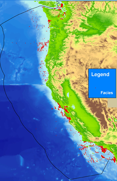
The facies layer can be used to investigate the known information about a particular area of the sea floor. These data are intended for science researchers, policy makers, students, and the general public. The data can be used with geographic information systems (GIS) software to display geologic and oceanographic information.

How was the data set created?

  1. From what previous works were the data drawn?
    PAC_FAC.txt (source 1 of 1)
    Various, Unknown, See Data Sources page (https://pubs.usgs.gov/2006/ds/182.pac_sources.html and links therein) or the relationally linked file PAC_SRC.txt (https://pubs.usgs.gov/ds/2006/182/data/pac_src.txt), and links provided therein, within this publication for the specific sources and associated metadata.: Various, Various.

    Type_of_Source_Media: Hard copy and digital
    Source_Contribution:
    Point locations, descriptions, and various analytical data (textural, granulometric, geochemical, geophysical, acoustic) on sediments, rock exposure, and benthos. Contributions vary with source.
    Over 300 sources, both published and unpublished, are used as the sources of information for usSEABED. Metadata for each source is given through the Data Sources page (https://pubs.usgs.gov/ds/2006/182/pac_sources.html) and relationally linked to the data through the file https://pubs.usgs.gov/ds/2006/182/data/pac_src.txt (PAC_SRC.txt). Sources include the U.S. Geological Survey (USGS), the U.S. Army Corps of Engineers (USACE), Minerals Management Service (MMS), National Oceanic and Atmospheric Administration (NOAA), the University of Washington, Seattle, Oregon State University, Corvallis, Universities of California, Berkeley, Los Angeles, and San Diego, University of Southern California, San Jose and Humboldt State Universities, Naval Postgraduate School, Virginia Institute of Marine Science (VIMS) and other educational institutions, the Maryland and New Jersey State Geological Surveys (MGS, NJGS), U.S. Navy, Southern California Coastal Water Research Project (SCCWRP), other local and regional consortia and authorities, NOAA's National Geophysical Data Center (NGDC), the Smithsonian Institution, and others.
  2. How were the data generated, processed, and modified?
    Date: 23-Dec-2005 (process 1 of 4)
    Source data may be digitized as necessary (typed or scanned in), with a visual inspection of digitized data to the source report and corrections as necessary, and are tested for completeness in Microsoft Excel as appropriate. Other digital data may be decoded using source-specific programs, downloaded via the web, or sent directly to the USGS or University of Colorado via email. Data are formatted into the dbSEABED Data Entry template (db9_DataEntry.xls, version 05/27/05) by hand, and tested using the dbSEABED relational database program (RDBi, version 01/05/2005) for correctness of formatting. For consistency, simple unit changes may be done. Data are compiled into source data resource files (DRF) and were processed on 12/22/05 through the dbSEABED data mining program (MNEv, version 12/18/2005) program, using the dbSEABED thesaurus (db9_dict.rtf, version 10/29/2005) and component set up file for U.S. waters (SET_ABUN.txt, version 07/20/2005), and the facies set up file for U.S. waters (SET_FACI.txt, version 07/20/2005). Data are iteratively reprocessed and corrected until noted errors are fixed, as recorded by the _RBDS.2fx and _MNE.DGN files. Data are exercised in a GIS for location tests and useability. Person who carried out this activity:
    U.S. Geological Survey
    Attn: Jane A. Reid
    Geologist
    Pacific Coastal and Marine Science Center
    Santa Cruz, CA
    USA

    (831) 427-4727 (voice)
    jareid@usgs.gov
    Contact_Instructions: Email preferred
    Data sources used in this process:
    • PAC_FAC.txt
    Data sources produced in this process:
    • pac_fac.shp
    • pac_fac.dbf
    • pac_fac.shx
    Date: 26-Apr-2018 (process 2 of 4)
    Keywords added to metadata support discovery in the USGS Coastal and Marine Geology Data Catalog. Person who carried out this activity:
    U.S. Geological Survey
    Attn: Alan O. Allwardt
    Contractor -- Information Specialist
    2885 Mission Street
    Santa Cruz, CA

    831-460-7551 (voice)
    831-427-4748 (FAX)
    aallwardt@usgs.gov
    Date: 04-Dec-2019 (process 3 of 4)
    Edits were made to bring the metadata up to current PCMSC standards including adding a doi# link, correcting typos, refining keywords, and using current access and distribution liability statements. Point of Contact and Metadata Contact information sections were changed to static PCMSC contact information. Users are advised to compare the metadata date of this file to any similar file to ensure they are using the most recent version. Person who carried out this activity:
    Susan A Cochran
    U.S. Geological Survey, Pacific Coastal and Marine Science Center
    2885 Mission St.
    Santa Cruz, CA
    United States

    831-460-7545 (voice)
    scochran@usgs.gov
    Date: 19-Oct-2020 (process 4 of 4)
    Edited metadata to add keywords section with USGS persistent identifier as theme keyword. No data were changed. Person who carried out this activity:
    U.S. Geological Survey
    Attn: VeeAnn A. Cross
    Marine Geologist
    384 Woods Hole Road
    Woods Hole, MA

    508-548-8700 x2251 (voice)
    508-457-2310 (FAX)
    vatnipp@usgs.gov
  3. What similar or related data should the user be aware of?

How reliable are the data; what problems remain in the data set?

  1. How well have the observations been checked?
    Accuracy of each attribute is dependent on the accuracy of the original source description and the values calculated by the mining software, dbSEABED. Values are based on filters using fuzzy set theory and represent a measure of truth about the attribute.
  2. How accurate are the geographic locations?
    Locational accuracy is dependent on both the accuracy of the navigational technique and the level of detail about the location as recorded in the individual data sources, and may vary widely (ie.g., from 0.005 km (differential GPS) in the more recent surveys to greater than 2 km based on radar, Loran, or dead reckoning in the older surveys. Users of the data should note the metadata written about the original sources and use their own criteria for assessing the accuracy of the locations.
  3. How accurate are the heights or depths?
    Depth determinations, both water depth and subsample depth, are dependent on the accuracy of the depth determination technique and the level of detail noted in the original source. Users of the data should note the metadata written about the original sources and use their own criteria for assessing the accuracy of the locations.
  4. Where are the gaps in the data? What is missing?
    Additional useable data may exist in this area; the authors appreciate any information and leads.
  5. How consistent are the relationships among the observations, including topology?
    Data in the usSEABED data collection are based on the observations and analyses of others, filtered through a unifying and mining software. Each source report varies in type of information/data recorded and format. Only those observations that are recorded can be filtered and mined; only presence (not absences) of information can be noted.

How can someone get a copy of the data set?

Are there legal restrictions on access or use of the data?
Access_Constraints: None
Use_Constraints:
USGS-authored or produced data and information are in the public domain from the U.S. Government and are freely redistributable with proper metadata and source attribution. Please recognize and acknowledge the U.S. Geological Survey as the originator(s) of the dataset and in products derived from these data. This information is not intended for navigation purposes.
  1. Who distributes the data set? (Distributor 1 of 1)
    U.S. Geological Survey
    Attn: Jane A. Reid
    Geologist
    2885 Mission Street
    Santa Cruz, CA
    USA

    (831) 427-4727 (voice)
    jareid@usgs.gov
    Contact_Instructions: Email preferred
  2. What's the catalog number I need to order this data set? Downloadable Data: USGS Data Series 182 (data downloadable through the web)
  3. What legal disclaimers am I supposed to read?
    Unless otherwise stated, all data, metadata and related materials are considered to satisfy the quality standards relative to the purpose for which the data were collected. Although these data and associated metadata have been reviewed for accuracy and completeness and approved for release by the U.S. Geological Survey (USGS), no warranty expressed or implied is made regarding the display or utility of the data on any other system or for general or scientific purposes, nor shall the act of distribution constitute any such warranty.
  4. How can I download or order the data?
  5. What hardware or software do I need in order to use the data set?
    None; these data are provided as comma-delimited text files useable in most softwares. Additionally, these data are available in Environmental Systems Research Institute (ESRI) shapefile format. The user must have ArcGIS or ArcView 3.0 or greater software to read and process the data file. In lieu of ArcView or ArcGIS, the user may utilize another GIS application package capable of importing the data. A free data viewer, ArcExplorer, capable of displaying the data is available from ESRI at https://www.esri.com.

Who wrote the metadata?

Dates:
Last modified: 19-Oct-2020
Metadata author:
U.S. Geological Survey, Pacific Coastal and Marine Science Center
Attn: PCMSC Science Data Coordinator
2885 Mission Street
Santa Cruz, CA
US

831-427-4747 (voice)
pcmsc_data@usgs.gov
Metadata standard:
Content Standard for Digital Geospatial Metadata (FGDC-STD-001-1998)

This page is <https://cmgds.marine.usgs.gov/catalog/pcmsc/SeriesReports/DS_DDS/DS_182/pac_fac.faq.html>
Generated by mp version 2.9.50 on Tue Sep 21 18:17:35 2021