ALASKA1964_RUNUP - Alaska 1964 Tsunami Runup Heights at Seaside, Oregon (alaska1964_runup.shp)

Metadata also available as - [Questions & Answers] - [Parseable text] - [XML]

Metadata:

Identification_Information:
Citation:
Citation_Information:
Originator: Tom Horning
Originator: NOAA Center for Tsunami Research
Publication_Date: 2006
Title:
ALASKA1964_RUNUP - Alaska 1964 Tsunami Runup Heights at Seaside, Oregon (alaska1964_runup.shp)
Edition: 1
Geospatial_Data_Presentation_Form: vector digital data
Series_Information:
Series_Name: Data Series
Issue_Identification: 236
Publication_Information:
Publication_Place: Menlo Park, California
Publisher: U.S. Geological Survey
Online_Linkage: http://pubs.usgs.gov/ds/2006/236/download/alaska1964_runup.zip
Online_Linkage: http://pubs.usgs.gov/ds/2006/236/catalog.shtml
Larger_Work_Citation:
Citation_Information:
Originator: Florence L. Wong
Originator: Angie J. Venturato
Originator: Eric L. Geist
Publication_Date: 2006
Title:
Seaside, Oregon Tsunami Pilot Study -- Modernization of FEMA Flood Hazard Maps: GIS Data
Geospatial_Data_Presentation_Form: vector digital data
Series_Information:
Series_Name: Data Series
Issue_Identification: 236
Publication_Information:
Publication_Place: Menlo Park, California
Publisher: U.S. Geological Survey
Online_Linkage: http://pubs.usgs.gov/ds/2006/236/
Description:
Abstract:
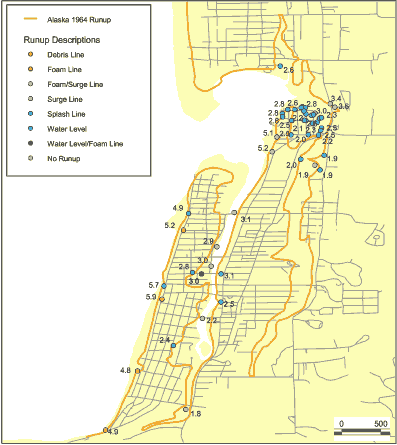
This data set is a point shapefile representing tsunami inundation runup heights for the Alaska 1964 event based on observations and associated information obtained by Tom Horning (1997). The geospatial data was digitized from a points drawn by Tom Horning on an orthophoto taken in 1997.
Purpose:
This data set is one of a collection of spatially referenced digital files in a geographic information system related to the Seaside, Oregon, Tsunami Pilot Study.
Federal Emergency Management Agency (FEMA) Federal Insurance Rate Map (FIRM) guidelines do not currently exist for conducting and incorporating tsunami hazard assessments that reflect the substantial advances in tsunami research achieved in the last two decades (Tsunami Pilot Study Working Group, 2006). Therefore, as part of the FEMA Modernization Program, a Tsunami Pilot Study was carried out in the Seaside/Gearhart, Oregon, area to provide information from which tsunami mapping guidelines could be developed. This area was chosen because it is typical of coastal communities in the section of the Pacific Coast from Cape Mendocino to the Strait of Juan de Fuca. There was also considerable interest shown by state agencies and local stakeholders in mapping the tsunami threat to this region. The study was an interagency effort by scientists from the U.S. Geological Survey, the National Oceanic and Atmospheric Administration, the University of Southern California, and the Middle East Technical University. We present the GIS data from that report in this publication.
These data are intended for science researchers, students, policy makers, and the general public. The data can be used with geographic information systems (GIS) software to display geologic and oceanographic information.
Time_Period_of_Content:
Time_Period_Information:
Single_Date/Time:
Calendar_Date: 2006
Currentness_Reference: publication date
Status:
Progress: Complete
Maintenance_and_Update_Frequency: None planned
Spatial_Domain:
Bounding_Coordinates:
West_Bounding_Coordinate: -123.934996
East_Bounding_Coordinate: -123.913261
North_Bounding_Coordinate: 46.018684
South_Bounding_Coordinate: 45.978450
Keywords:
Theme:
Theme_Keyword_Thesaurus: USGS Metadata Identifier
Theme_Keyword: USGS:b171edf6-b0f4-42f7-8af1-75597830175f
Theme:
Theme_Keyword_Thesaurus: None
Theme_Keyword: National Oceanic and Atmospheric Administration
Theme_Keyword: NOAA
Theme_Keyword: Center for Tsunami Research
Theme_Keyword: U.S. Geological Survey
Theme_Keyword: USGS
Theme_Keyword: Coastal and Marine Geology Program
Theme_Keyword: CMGP
Theme_Keyword: Western Coastal and Marine Geology
Theme_Keyword: WCMG
Theme_Keyword: tsunami runup heights
Theme_Keyword: observations
Theme_Keyword: point shapefile
Theme:
Theme_Keyword_Thesaurus: ISO 19115 Topic Category
Theme_Keyword: oceans
Theme_Keyword: environment
Theme_Keyword: geoscientificInformation
Theme:
Theme_Keyword_Thesaurus: USGS Thesaurus
Theme_Keyword: tsunamis
Theme_Keyword: geospatial datasets
Place:
Place_Keyword_Thesaurus: Geographic Names Information System
Place_Keyword: Seaside
Place_Keyword: Oregon
Place_Keyword: USA
Place_Keyword: United States
Place_Keyword: North America
Temporal:
Temporal_Keyword_Thesaurus: none
Temporal_Keyword: 1997
Access_Constraints: None.
Use_Constraints:
These data were created for the sole purpose of the Seaside, Oregon, Tsunami Pilot Study. It is not meant for navigational means. The National Oceanic and Atmospheric Administration makes no expressed or implied warranty regarding the accuracy of these data.
The act of distribution shall not constitute any such warranty, and no responsibility is assumed by the U.S. Geological Survey in the use of these data on any other system.
Public domain data from the U.S. Government are freely redistributable with proper metadata and source attribution. Please recognize the National Oceanic and Atmospheric Administration (NOAA) as the originator of the dataset.
Point_of_Contact:
Contact_Information:
Contact_Organization_Primary:
Contact_Organization: NOAA Center for Tsunami Research
Contact_Address:
Address_Type: mailing address
Address: 7600 Sand Point Way NE
City: Seattle
State_or_Province: Washington
Postal_Code: 98115
Country: USA
Contact_Voice_Telephone: 206-526-6556
Contact_Electronic_Mail_Address: Angie.J.Venturato@noaa.gov
Browse_Graphic:
Browse_Graphic_File_Name: http://pubs.usgs.gov/ds/2006/236/metadata/alaska1964_runup.gif
Browse_Graphic_File_Description:
Observations of the Alaska 1964 event as described by Fiedorowicz (1997) and updated by Horning.
Browse_Graphic_File_Type: GIF
Data_Set_Credit: Tom Horning (Horning Geosciences)
Native_Data_Set_Environment:
Microsoft Windows XP Version 5.1 (Build 2600) Service Pack 2; ESRI ArcCatalog 9.1.0.722
Cross_Reference:
Citation_Information:
Originator: Tsunami Pilot Study Working Group
Publication_Date: 2006
Title:
Seaside, Oregon Tsunami Pilot Study -- Modernization of FEMA Flood Hazard Maps
Edition: 1
Series_Information:
Series_Name: Open-File Report
Issue_Identification: 2006-1234
Publication_Information:
Publication_Place: Menlo Park, California
Publisher: U.S. Geological Survey
Online_Linkage: http://pubs.usgs.gov/of/2006/1234/
Cross_Reference:
Citation_Information:
Originator: Fiedorowicz, B.K.
Publication_Date: 1997
Title:
Geologic evidence of historic and prehistoric tsunami inundation at Seaside, Oregon
Publication_Information:
Publication_Place: Portland, Oregon
Publisher: Portland State University
Other_Citation_Details: Portland State University, M.S. Thesis
Online_Linkage: http://nwdata.geol.pdx.edu/Thesis/FullText/1997/Fiedorowicz/
Data_Quality_Information:
Attribute_Accuracy:
Attribute_Accuracy_Report:
contact Tom Horning Horning Geosciences Seaside, Oregon 97138
Logical_Consistency_Report:
The data set was checked for logical consistency by visually comparing the polyline to the hand-drawn line on the orthophoto.
Completeness_Report: Complete.
Lineage:
Source_Information:
Source_Citation:
Citation_Information:
Originator: Tom Horning
Publication_Date: Unpublished Material
Title:
Runup Line for 1964 Tsunami, Seaside, Oregon, Good Friday Tsunami from the Great Alaska Earthquake
Source_Scale_Denominator: 24000
Type_of_Source_Media: paper
Source_Time_Period_of_Content:
Time_Period_Information:
Single_Date/Time:
Calendar_Date: 1997
Source_Currentness_Reference: refer to cross reference
Source_Citation_Abbreviation: 1997ortho
Source_Contribution:
hand-drawn line representing tsunami inundation based on observation of the 1964 Alaska event
Process_Step:
Process_Description:
DATA CONVERSION. The paper map was scanned to a digital orthophoto tiff.
Source_Used_Citation_Abbreviation: ak64horning map
Process_Date: 200408
Source_Produced_Citation_Abbreviation: ak64horning
Process_Step:
Process_Description:
DIGITIZATION. The handdrawn points on the map was digitized to a point shapefile in map units.
Source_Used_Citation_Abbreviation: ak64horning
Process_Date: 200408
Source_Produced_Citation_Abbreviation: tmppoints
Process_Step:
Process_Description:
GEOREFERENCING. The vector shapefile was georeferenced by using USGS digital raster graphics to correlate map units to geographic coordinates. ShapeWarp 2.2 (Kenneth McVay) was used to convert the shapefile to geographic coordinates.
Source_Used_Citation_Abbreviation: tmppoint
Process_Date: 200408
Source_Produced_Citation_Abbreviation: alaska1964_runup
Process_Step:
Process_Description:
Edited metadata to add keywords section with USGS persistent identifier as theme keyword. No data were changed.
Process_Date: 20201019
Process_Contact:
Contact_Information:
Contact_Organization_Primary:
Contact_Organization: U.S. Geological Survey
Contact_Person: VeeAnn A. Cross
Contact_Position: Marine Geologist
Contact_Address:
Address_Type: Mailing and Physical
Address: 384 Woods Hole Road
City: Woods Hole
State_or_Province: MA
Postal_Code: 02543-1598
Contact_Voice_Telephone: 508-548-8700 x2251
Contact_Facsimile_Telephone: 508-457-2310
Contact_Electronic_Mail_Address: vatnipp@usgs.gov
Process_Step:
Process_Description:
Edited metadata for minor typos and to bring it up to PCMSC standards, including adding USGS Thesaurus keyword terms. No data were changed.
Process_Date: 20211008
Process_Contact:
Contact_Information:
Contact_Organization_Primary:
Contact_Organization: U.S. Geological Survey
Contact_Person: Susan Cochran
Contact_Position: Geologist
Contact_Address:
Address_Type: Mailing and Physical
Address: 2885 Mission Street
City: Santa Cruz
State_or_Province: CA
Postal_Code: 95060
Contact_Voice_Telephone: 831-460-7545
Contact_Electronic_Mail_Address: scochran@usgs.gov
Spatial_Data_Organization_Information:
Direct_Spatial_Reference_Method: Vector
Point_and_Vector_Object_Information:
SDTS_Terms_Description:
SDTS_Point_and_Vector_Object_Type: Entity point
Point_and_Vector_Object_Count: 21
Spatial_Reference_Information:
Horizontal_Coordinate_System_Definition:
Geographic:
Latitude_Resolution: 1.000000
Longitude_Resolution: 1.000000
Geographic_Coordinate_Units: Decimal degrees
Geodetic_Model:
Horizontal_Datum_Name: North American Datum of 1983
Ellipsoid_Name: Geodetic Reference System 80
Semi-major_Axis: 6378137.000000
Denominator_of_Flattening_Ratio: 298.257222
Entity_and_Attribute_Information:
Detailed_Description:
Entity_Type:
Entity_Type_Label: alaska1964_runup
Entity_Type_Definition: name of shapefile
Entity_Type_Definition_Source: none
Attribute:
Attribute_Label: FID
Attribute_Definition: Internal feature number.
Attribute_Definition_Source: ESRI
Attribute_Domain_Values:
Unrepresentable_Domain:
Sequential unique whole numbers that are automatically generated.
Attribute:
Attribute_Label: Shape
Attribute_Definition: Feature geometry.
Attribute_Definition_Source: ESRI
Attribute_Domain_Values:
Unrepresentable_Domain: Coordinates defining the features.
Attribute:
Attribute_Label: ID
Attribute_Definition: identification number
Attribute_Definition_Source: ESRI
Attribute_Domain_Values:
Unrepresentable_Domain: Default ESRI enumeration.
Attribute:
Attribute_Label: FEET
Attribute_Definition: runup height in feet
Attribute_Definition_Source: Horning
Attribute_Domain_Values:
Range_Domain:
Range_Domain_Minimum: 7
Range_Domain_Maximum: 21
Attribute_Units_of_Measure: feet
Attribute:
Attribute_Label: METERS
Attribute_Definition: runup height in meters
Attribute_Definition_Source: Horning
Attribute_Domain_Values:
Range_Domain:
Range_Domain_Minimum: 2.1
Range_Domain_Maximum: 6.4
Attribute_Units_of_Measure: meters
Attribute:
Attribute_Label: MHW
Attribute_Definition: runup height in meters based on Mean High Water datum
Attribute_Definition_Source: NOS
Attribute_Domain_Values:
Range_Domain:
Range_Domain_Minimum: 1.1
Range_Domain_Maximum: 5.4
Attribute_Units_of_Measure: meters
Attribute:
Attribute_Label: X_COORD
Attribute_Definition: longitude
Attribute_Definition_Source: ESRI
Attribute_Domain_Values:
Unrepresentable_Domain: Coordinates defined by features.
Attribute:
Attribute_Label: Y_COORD
Attribute_Definition: latitude
Attribute_Definition_Source: ESRI
Attribute_Domain_Values:
Unrepresentable_Domain: Coordinates defined by features.
Distribution_Information:
Distributor:
Contact_Information:
Contact_Organization_Primary:
Contact_Organization: U.S. Geological Survey
Contact_Address:
Address_Type: mailing address
Address: Information Services Box 25286
City: Denver
State_or_Province: Colorado
Postal_Code: 80225-0286
Country: USA
Contact_Voice_Telephone: 1-888-275-8747
Contact_Electronic_Mail_Address: infoservices@usgs.gov
Resource_Description: Downloadable Data: U.S. Geological Survey Data Series 236
Distribution_Liability:
Although these data have been used by the U.S. Geological Survey (USGS), U.S. Department of the Interior (DOI), no warranty expressed or implied is made by the U.S. Geological Survey as to the accuracy of the data. The act of distribution shall not constitute any such warranty, and no responsibility is assumed by the USGS in the use of these data or related materials.
Any use of trade, product, or firm names is for descriptive purposes only and does not imply endorsement by the U.S. Government.
Standard_Order_Process:
Digital_Form:
Digital_Transfer_Information:
Format_Name: shapefile
Format_Version_Number: 9.1
Format_Specification: ArcGIS shapefile
File_Decompression_Technique: no compression applied
Transfer_Size: 0.020
Digital_Transfer_Option:
Online_Option:
Computer_Contact_Information: Access_Instructions: Data may be downloaded via the World Wide Web (WWW).
Fees: None.
Technical_Prerequisites:
These data are available in Environmental Systems Research Institute (ESRI) shapefile format. The user must have ArcGIS or ArcView 3.0 or greater software to read and process the data file. In lieu of ArcView or ArcGIS, the user may utilize another GIS application package capable of importing the data. A free data viewer, ArcExplorer, capable of displaying the data is available from ESRI at www.esri.com.
Metadata_Reference_Information:
Metadata_Date: 20211008
Metadata_Contact:
Contact_Information:
Contact_Organization_Primary:
Contact_Organization: NOAA Center for Tsunami Research
Contact_Person: Angie J. Venturato
Contact_Address:
Address_Type: mailing address
Address: 7600 Sand Point Way NE
City: Seattle
State_or_Province: Washington
Postal_Code: 98115
Country: USA
Contact_Voice_Telephone: 206-526-6556
Contact_Electronic_Mail_Address: Angie.J.Venturato@noaa.gov
Metadata_Standard_Name: Content Standard for Digital Geospatial Metadata
Metadata_Standard_Version: FGDC-STD-001-1998
Metadata_Time_Convention: local time
Metadata_Access_Constraints: None
Metadata_Use_Constraints: None

This page is <https://cmgds.marine.usgs.gov/catalog/pcmsc/SeriesReports/DS_DDS/DS_236/alaska1964_runup.shp.html>
Generated by mp version 2.9.50 on Wed Oct 13 09:08:57 2021