Citation:
Citation_Information:
Originator: Federal Emergency Management Administration
Originator: Florence L. Wong
Publication_Date: 2006
Title:
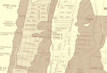
F4100320002C.TIF - FEMA Flood Insurance Rate Maps for the Seaside-Gearhart, Oregon, Area: Seaside 2
Edition: 1
Geospatial_Data_Presentation_Form: map
Series_Information:
Series_Name: Data Series
Issue_Identification: 236
Publication_Information:
Publication_Place: Western Coastal and Marine Geology, Menlo Park, California
Publisher: U.S. Geological Survey, Coastal and Marine Geology Program
Online_Linkage: http://pubs.usgs.gov/ds/2006/236/download/f4100320002c.zip
Online_Linkage: http://pubs.usgs.gov/ds/2006/236/catalog.shtml
Larger_Work_Citation:
Citation_Information:
Originator: Florence L. Wong
Originator: Angie J. Venturato
Originator: Eric L. Geist
Publication_Date: 2006
Title:
Seaside, Oregon, Tsunami Pilot Study - Modernization of FEMA Flood Hazard Maps: GIS Data
Geospatial_Data_Presentation_Form: raster digital data
Series_Information:
Series_Name: Data Series
Issue_Identification: 236
Publication_Information:
Publication_Place: Menlo Park, California
Publisher: U.S. Geological Survey
Online_Linkage: http://pubs.usgs.gov/ds/2006/236/
Description:
Abstract:
FEMA's Flood Insurance Rate Map (FIRM) depicts the spatial extent of Special Flood Hazard Areas (SFHAs) and other thematic features related to flood risk assessment. FIRMs also provide a basis for establishing flood insurance coverage premium rates offered through the National Flood Insurance Program (NFIP). These maps were published as paper documents, which have been scanned into image files (TIFF) as part of FEMA's FIRM modernization process. This is one of three scanned maps for the Seaside-Gearhart area - 410030 0001 D, 410032 0001 C, and 410032 0002 C - that were georeferenced for the probabilistic tsunami hazard assessment project.
Purpose:
This data set is one of a collection of digital files of a geographic information system of spatially referenced data related to the Seaside, Oregon, Tsunami Pilot Study.
Federal Emergency Management Agency (FEMA) Federal Insurance Rate Map (FIRM) guidelines do not currently exist for conducting and incorporating tsunami hazard assessments that reflect the substantial advances in tsunami research achieved in the last two decades (Tsunami Pilot Study Working Group, 2006). Therefore, as part of FEMAs Modernization Program, a Tsunami Pilot Study was carried out in the Seaside/Gearhart, Oregon, area to provide information from which tsunami mapping guidelines could be developed. This area was chosen because it is typical of coastal communities in the section of the Pacific Coast from Cape Mendocino to the Strait of Juan de Fuca. There was also considerable interest shown by state agencies and local stakeholders in mapping the tsunami threat to this area. The study was an interagency effort by scientists from the U.S. Geological Survey, the National Oceanic and Atmospheric Administration, the University of Southern California, and the Middle East Technical University. We present the GIS data from that report in this publication.
These data are intended for science researchers, students, policy makers, and the general public. The data can be used with geographic information systems (GIS) software to display geologic and oceanographic information.
Supplemental_Information:
The following explanatory text was transcribed from Flood Insurance Rate Map 410027 0019 B, Clatsop County (Unincorporated Areas), revised June 16, 1999 (FEMA, 1999).
Elevations referenced to the National Geodetic Vertical Datum of 1929 (NGVD29).
Zone A: Areas of 100-year flood; base flood elevations and flood hazard factors not determined.
Zone A0: Areas of 100-year shallow flooding where depths are between one (1) and three (3) feet; average depths of inundation are shown, but no flood hazard factors are determined.
Zone AH: Areas of 100-year shallow flooding where depths are between one (1) and three (3) feet; base flood elevations are shown, but no flood hazard factors are determined.
Zone A1-A30: Areas of 100-year flood; base flood elevations and flood hazard factors determined.
Zone A99: Areas of 100-year flood to be protected by flood protection system under construction; base flood elevations and flood hazard factors not determined.
Zone B: Areas between limits of the 100-year flood and 500-year flood; or certain areas subject to 100-year flooding with average depths less than one (1) foot or where the contributing drainage area is less than one square mile; or areas protected by levees from the base flood. (Medium shading)
Zone C: Areas of minimal flooding. (No shading)
Zone D: Areas of undetermined, but possible, flood hazards.
Zone V: Areas of 100-year coastal flood with velocity (wave action); base flood elevations and flood hazard factors not determined.
Zone V1-V30: Areas of 100-year coastal flood with velocity (wave action); base flood elevations and flood hazard factors determined.
Time_Period_of_Content:
Time_Period_Information:
Single_Date/Time:
Calendar_Date: 1981
Currentness_Reference: ground condition
Status:
Progress: Complete
Maintenance_and_Update_Frequency: None planned
Spatial_Domain:
Bounding_Coordinates:
West_Bounding_Coordinate: -123.941049
East_Bounding_Coordinate: -123.918417
North_Bounding_Coordinate: 45.981637
South_Bounding_Coordinate: 45.948457
Keywords:
Theme:
Theme_Keyword_Thesaurus: USGS Metadata Identifier
Theme_Keyword: USGS:6ea70397-de3f-48a3-b4ba-8bce82e9c392
Theme:
Theme_Keyword_Thesaurus: None
Theme_Keyword: U.S. Geological Survey
Theme_Keyword: USGS
Theme_Keyword: Coastal and Marine Geology Program
Theme_Keyword: CMGP
Theme_Keyword: Western Coastal and Marine Geology
Theme_Keyword: WCMG
Theme_Keyword: probabilistic tsunami hazard assessment
Theme_Keyword: coastal geology
Theme_Keyword: PTHA
Theme_Keyword: tsunami probability
Theme_Keyword: tsunami hazard
Theme_Keyword: FEMA FIRM flood insurance rate map
Theme_Keyword: GeoTIFF image
Theme:
Theme_Keyword_Thesaurus: USGS Thesaurus
Theme_Keyword: tsunamis
Theme_Keyword: geospatial datasets
Theme:
Theme_Keyword_Thesaurus: ISO 19115 Topic Category
Theme_Keyword: oceans
Theme_Keyword: environment
Theme_Keyword: geoscientificInformation
Theme_Keyword: imageryBaseMapsEarthCover
Place:
Place_Keyword_Thesaurus: Geographic Names Information System
Place_Keyword: Seaside
Place_Keyword: Gearhart
Place_Keyword: Oregon
Place_Keyword: USA
Place_Keyword: United States
Place_Keyword: North America
Place:
Place_Keyword_Thesaurus: GEOnet Names Server
Place_Keyword: north Pacific Ocean
Access_Constraints: None.
Use_Constraints:
The data, digital results, GIS layers, and map products in this database have been created specifically as part of a pilot study for FEMA's modernization of Flood Insurance Rate Maps (FIRMs) project. The results of the pilot study are intended to help FEMA draft new guidelines related to tsunami flooding for Coastal Flood Hazard Analysis and Mapping for the Pacific Coast of the United States. The results are intrinsically probabilistic and designed according to FEMA flood zone specifications: annual probabilities of exceedance of 1% and 0.2%. The data, digital results, GIS layers, and map products are not intended for other uses. In particular, the 1% and 0.2% annual exceedance probability tsunami flood maps are not to be used for emergency planning, evacuation, or other insurance purposes. Please refer to the National Tsunami Hazard Mitigation Program tsunami inundation maps for use in emergency planning.
These data are not to be used for navigation purposes. Mariners should refer to the appropriate nautical chart.
Public domain data from the U.S. Government are freely redistributable with proper metadata and source attribution. Please recognize the U.S. Geological Survey as the originator of the dataset.
Point_of_Contact:
Contact_Information:
Contact_Person_Primary:
Contact_Person: Florence L. Wong
Contact_Organization: U.S. Geological Survey
Contact_Position: Geologist
Contact_Address:
Address_Type: mailing and physical address
Address: 345 Middlefield Road, MS 999
City: Menlo Park
State_or_Province: California
Postal_Code: 94025
Country: USA
Contact_Voice_Telephone: 650-329-5327
Contact_Facsimile_Telephone: 650-329-5190
Contact_Electronic_Mail_Address: [email protected]
Browse_Graphic:
Native_Data_Set_Environment:
Microsoft Windows 2000 Version 5.0 (Build 2195) Service Pack 4; ESRI ArcCatalog 9.1.0.722
Cross_Reference:
Citation_Information:
Originator: Tsunami Pilot Study Working Group
Publication_Date: 2006
Title:
Seaside, Oregon Tsunami Pilot Study - Modernization of FEMA Flood Hazard Maps
Edition: 1
Series_Information:
Series_Name: Open-File Report
Issue_Identification: 2006-1234
Publication_Information:
Publication_Place: Menlo Park, California
Publisher: U.S. Geological Survey
Online_Linkage: http://pubs.usgs.gov/of/2006/1234/