Citation:
Citation_Information:
Originator: Florence L. Wong
Originator: Eric L. Geist
Publication_Date: 2006
Title:
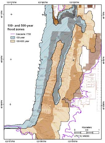
PROBZONES - Generalized 100- and 500-year flood zones for Seaside, Oregon, determined by probabilistic tsunami hazard analysis
Edition: 1
Geospatial_Data_Presentation_Form: vector digital data
Series_Information:
Series_Name: Data Series
Issue_Identification: 236
Publication_Information:
Publication_Place: Western Coastal and Marine Geology, Menlo Park, CA
Publisher: U.S. Geological Survey, Coastal and Marine Geology Program
Online_Linkage: http://pubs.usgs.gov/ds/2006/236/download/probzones.zip
Online_Linkage: http://pubs.usgs.gov/ds/2006/236/catalog.shtml
Larger_Work_Citation:
Citation_Information:
Originator: Florence L. Wong
Originator: Angie J. Venturato
Originator: Eric L. Geist
Publication_Date: 2006
Title:
Seaside, Oregon Tsunami Pilot Study - Modernization of FEMA Flood Hazard Maps: GIS Data
Edition: 1.0
Series_Information:
Series_Name: Data Series
Issue_Identification: 236
Publication_Information:
Publication_Place: Western Coastal and Marine Geology, Menlo Park, CA
Publisher: U.S. Geological Survey, Coastal and Marine Geology Program
Online_Linkage: http://pubs.usgs.gov/ds/2006/236/
Description:
Abstract:
PROBZONES is a generalized polygon layer outlining areas in the Seaside-Gearhart, Oregon, area subject to the 100-year and 500-year flood as determined by probabilistic tsunami hazard analysis (PTHA).
Purpose:
This data set is one of a collection of digital files of a geographic information system of spatially referenced data related to the Seaside, Oregon, Tsunami Pilot Study.
Federal Emergency Management Agency (FEMA) Federal Insurance Rate Map (FIRM) guidelines do not currently exist for conducting and incorporating tsunami hazard assessments that reflect the substantial advances in tsunami research achieved in the last two decades (Tsunami Pilot Study Working Group, 2006). Therefore, as part of FEMAs Modernization Program, a Tsunami Pilot Study was carried out in the Seaside/Gearhart, Oregon, area to provide information from which tsunami mapping guidelines could be developed. This area was chosen because it is typical of coastal communities in the section of the Pacific Coast from Cape Mendocino to the Strait of Juan de Fuca. There was also considerable interest shown by state agencies and local stakeholders in mapping the tsunami threat to this area. The study was an interagency effort by scientists from the U.S. Geological Survey, the National Oceanic and Atmospheric Administration, the University of Southern California, and the Middle East Technical University. We present the GIS data from that report in this publication.
These data are intended for science researchers, students, policy makers, and the general public. The data can be used with geographic information systems (GIS) software to display geologic and oceanographic information.
Time_Period_of_Content:
Time_Period_Information:
Single_Date/Time:
Calendar_Date: 2005
Currentness_Reference: ground condition
Status:
Progress: Complete
Maintenance_and_Update_Frequency: None planned
Spatial_Domain:
Bounding_Coordinates:
West_Bounding_Coordinate: -123.970020
East_Bounding_Coordinate: -123.904470
North_Bounding_Coordinate: 46.060000
South_Bounding_Coordinate: 45.965441
Keywords:
Theme:
Theme_Keyword_Thesaurus: USGS Metadata Identifier
Theme_Keyword: USGS:97ba1aa3-d817-4599-a36b-dc47d87492be
Theme:
Theme_Keyword_Thesaurus: None
Theme_Keyword: U.S. Geological Survey
Theme_Keyword: USGS
Theme_Keyword: Coastal and Marine Geology Program
Theme_Keyword: CMGP
Theme_Keyword: Western Coastal and Marine Geology
Theme_Keyword: WCMG
Theme_Keyword: probabilistic tsunami hazard analysis
Theme_Keyword: coastal geology
Theme_Keyword: PTHA
Theme_Keyword: tsunami probability
Theme_Keyword: tsunami hazard
Theme_Keyword: FEMA Flood Insurance Rate Map
Theme:
Theme_Keyword_Thesaurus: USGS Thesaurus
Theme_Keyword: tsunamis
Theme_Keyword: geospatial datasets
Theme:
Theme_Keyword_Thesaurus: ISO 19115 Topic Category
Theme_Keyword: environment
Theme_Keyword: geoscientificInformation
Theme_Keyword: oceans
Place:
Place_Keyword_Thesaurus: Geographic Names Information System
Place_Keyword: Seaside, Oregon
Place_Keyword: Gearhart, Oregon
Place_Keyword: Oregon
Place_Keyword: USA
Place_Keyword: United States
Place_Keyword: North America
Place:
Place_Keyword_Thesaurus: GEOnet Names Server
Place_Keyword: north Pacific Ocean
Access_Constraints: None.
Use_Constraints:
The data, digital results, GIS layers, and map products in this database have been created specifically as part of a pilot study for FEMA's modernization of Flood Insurance Rate Maps (FIRMs) project. The results of the pilot study are intended to help FEMA draft new guidelines related to tsunami flooding for Coastal Flood Hazard Analysis and Mapping for the Pacific Coast of the United States. The results are intrinsically probabilistic and designed according to FEMA flood zone specifications: annual probabilities of exceedance of 1% and 0.2%. The data, digital results, GIS layers, and map products are not intended for other uses. In particular, the 1% and 0.2% annual exceedance probability tsunami flood maps are not to be used for emergency planning, evacuation, or other insurance purposes. Please refer to the National Tsunami Hazard Mitigation Program tsunami inundation maps for use in emergency planning.
Please recognize the U.S. Geological Survey (USGS) as the source of this information.
Point_of_Contact:
Contact_Information:
Contact_Person_Primary:
Contact_Person: Florence L. Wong
Contact_Organization: U.S. Geological Survey
Contact_Position: Geologist
Contact_Address:
Address_Type: mailing and physical address
Address: 345 Middlefield Road, MS 999
City: Menlo Park
State_or_Province: California
Postal_Code: 94025
Country: USA
Contact_Voice_Telephone: 650-329-5327
Contact_Facsimile_Telephone: 650-329-5190
Contact_Electronic_Mail_Address: [email protected]
Browse_Graphic:
Native_Data_Set_Environment:
Microsoft Windows 2000 Version 5.0 (Build 2195) Service Pack 4; ESRI ArcCatalog 9.1.0.722
Cross_Reference:
Citation_Information:
Originator: Tsunami Pilot Study Working Group
Publication_Date: 2006
Title:
Seaside, Oregon Tsunami Pilot Study - Modernization of FEMA Flood Hazard Maps
Edition: 1
Series_Information:
Series_Name: Open-File Report
Issue_Identification: 2006-1234
Publication_Information:
Publication_Place: Western Coastal and Marine Geology, Menlo Park, California
Publisher: U.S. Geological Survey, Coastal and Marine Geology Program
Online_Linkage: http://pubs.usgs.gov/of/2006/1234/
Cross_Reference:
Citation_Information:
Originator:
Mofjeld, H.O., Venturato, A.J., Gonz\341lez, F.I., and Titov, V.V.
Publication_Date: 2004
Title: Background tides and sea level variations at Seaside, Oregon
Other_Citation_Details: NOAA, Technical Memorandum; OAR PMEL-126; 15 pages
Online_Linkage: http://www.pmel.noaa.gov/pubs/PDF/mofj2736/mofj2736.pdf
Cross_Reference:
Citation_Information:
Originator: Eric L. Geist
Publication_Date: 2005
Title:
Local Tsunami Hazards in the Pacific Northwest from Cascadia Subduction Zone Earthquakes
Series_Information:
Series_Name: Professional Paper
Issue_Identification: 1661-B
Publication_Information:
Publication_Place: Menlo Park, California
Publisher: U.S. Geological Survey, Coastal and Marine Geology Program
Other_Citation_Details: 21 pages
Online_Linkage: http://pubs.usgs.gov/pp/pp1661b/