Online Links:
Online Links:
| Value | Definition |
|---|---|
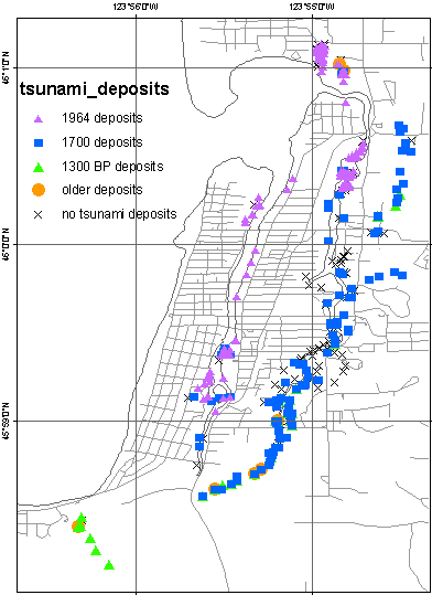
| SS6 | Seaside site 06/2004 |
| SS9 | Seaside 09/2004 |
| SSN | Necanicum River |
| SSS | Stanley Lake |
| SSW | Neawanna Creek |
| SSX | Neacoxie Creek |
| SSXa | Drainage to east of SSX |
| Value | Definition |
|---|---|
| yes | Deposit corresponds to event |
| no | Deposit does not correspond to event |
| Value | Definition |
|---|---|
| yes | Deposit corresponds to event |
| no | Deposit does not correspond to event |
| Value | Definition |
|---|---|
| yes | older tsunami deposit |
| no | Not an older deposit |
| Range of values | |
|---|---|
| Minimum: | 0 |
| Maximum: | 3 |
| Value | Definition |
|---|---|
| bp | basal peat |
| dc | detrital cap |
| fu | fining up |
| hd | historic documentation |
| lc | lateral continuity |
| ru | rip-up clasts |
| sa | anamolous sand layer |
| Value | Definition |
|---|---|
| yes | Deposit corresponded to event |
| no | Deposit did not correspond to event |
Fiedorowicz (1997); Fiedorowicz and Peters (2002); Jaffe, Peterson, and Peters
This data set is one of a collection of spatially referenced digital files in a geographic information system related to the Seaside, Oregon, Tsunami Pilot Study.
Federal Emergency Management Agency (FEMA) Federal Insurance Rate Map (FIRM) guidelines do not currently exist for conducting and incorporating tsunami hazard assessments that reflect the substantial advances in tsunami research achieved in the last two decades (Tsunami Pilot Study Working Group, 2006). Therefore, as part of the FEMA Modernization Program, a Tsunami Pilot Study was carried out in the Seaside/Gearhart, Oregon, area to provide information from which tsunami mapping guidelines could be developed. This area was chosen because it is typical of coastal communities in the section of the Pacific Coast from Cape Mendocino to the Strait of Juan de Fuca. There was also considerable interest shown by state agencies and local stakeholders in mapping the tsunami threat to this region. The study was an interagency effort by scientists from the U.S. Geological Survey, the National Oceanic and Atmospheric Administration, the University of Southern California, and the Middle East Technical University. We present the GIS data from that report in this publication.
These data are intended for science researchers, students, policy makers, and the general public. The data can be used with geographic information systems (GIS) software to display geologic and oceanographic information.
Online Links:
Online Links:
Are there legal restrictions on access or use of the data?Access_Constraints: None.
Use_Constraints:These data were created for the sole purpose of the Seaside, Oregon, Tsunami Pilot Study. It is not meant for navigational means. The National Oceanic and Atmospheric Administration makes no expressed or implied warranty regarding the accuracy of these data.
Public domain data from the U.S. Government are freely redistributable with proper metadata and source attribution. Please recognize the U.S. Geological Survey (USGS) as the originator of the dataset.
Although these data have been used by the U.S. Geological Survey (USGS), U.S. Department of the Interior (DOI), no warranty expressed or implied is made by the U.S. Geological Survey as to the accuracy of the data. The act of distribution shall not constitute any such warranty, and no responsibility is assumed by the USGS in the use of these data or related materials.
Any use of trade, product, or firm names is for descriptive purposes only and does not imply endorsement by the U.S. Government.
| Data format: | shapefile (version 9.1) ArcGIS shapefile Size: 0.020 |
|---|---|
| Network links: |
http://pubs.usgs.gov/ds/2006/236/download/tsunami_deposits.zip http://pubs.usgs.gov/ds/2006/236/catalog.shtml http://pubs.usgs.gov/ds/2006/236/ |
These data are available in Environmental Systems Research Institute (ESRI) shapefile format. The user must have ArcGIS or ArcView 3.0 or greater software to read and process the data file. In lieu of ArcView or ArcGIS, the user may utilize another GIS application package capable of importing the data. A free data viewer, ArcExplorer, capable of displaying the data is available from ESRI at www.esri.com.