Seafloor character--Offshore of Carpinteria, California

Metadata also available as - [Questions & Answers] - [Parseable text] - [XML]

Metadata:

Identification_Information:
Citation:
Citation_Information:
Originator: Eleyne L. Phillips
Originator: Mercedes D. Erdey
Originator: Guy R. Cochrane
Publication_Date: 2013
Title: Seafloor character--Offshore of Carpinteria, California
Geospatial_Data_Presentation_Form: GeoTiff
Series_Information:
Series_Name: Data Series
Issue_Identification: DS 781
Publication_Information:
Publication_Place: Reston, VA
Publisher: U.S. Geological Survey
Online_Linkage: https://doi.org/10.3133/ds781
Online_Linkage: Larger_Work_Citation:
Citation_Information:
Originator: Nadine E. Golden
Publication_Date: 2013
Title: California State Waters Map Series Data Catalog
Geospatial_Data_Presentation_Form: database
Series_Information:
Series_Name: Data Series
Issue_Identification: DS 781
Publication_Information:
Publication_Place: Reston, VA
Publisher: U.S. Geological Survey
Online_Linkage: https://doi.org/10.3133/ds781
Description:
Abstract:
This part of DS 781 presents data for the seafloor-character map of the Offshore of Carpinteria map area, California. The raster data file is included in "SeafloorCharacter_OffshoreCarpinteria.zip," which is accessible from https://pubs.usgs.gov/ds/781/OffshoreCarpinteria/data_catalog_OffshoreCarpinteria.html. These data accompany the pamphlet and map sheets of Johnson, S.Y., Dartnell, P., Cochrane, G.R., Golden, N.E., Phillips, E.L., Ritchie, A.C., Kvitek, R.G., Greene, H.G., Endris, C.A., Seitz, G.G., Sliter, R.W., Erdey, M.D., Wong, F.L., Gutierrez, C.I., Krigsman, L.M., Draut, A.E., and Hart, P.E. (S.Y. Johnson and S.A. Cochran, eds.), 2013, California State Waters Map Series—Offshore of Carpinteria, California: U.S. Geological Survey Scientific Investigations Map 3261, 42 p., 10 sheets, scale 1:24,000, https://doi.org/10.3133/sim3261.
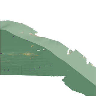
This raster-format seafloor-character map shows five substrate classes of Offshore of Carpinteria map area. The five substrate classes mapped in this area have been colored to indicate which of the following California Marine Life Protection Act depth zones and slope classes they belong: Depth Zone 2 (intertidal to 30 m), Depth Zone 3 (30 to 100 m), and Slope Class 1, 0 degrees to 5 degrees (flat). Depth Zone 1 (intertidal), Depth Zones 4 and 5 (greater than 100 m), and Slopes Classes 2 to 4, greater than 5 degrees (sloping to vertical) are not present in this map area. The map is created using a supervised classification method described by Cochrane (2008).
References Cited:
California Department of Fish and Game, 2008, California Marine Life Protection Act master plan for marine protected areas--Revised draft: California Department of Fish and Game, accessed April 5 2011, at http://www.dfg.ca.gov/mlpa/masterplan.asp.
Cochrane, G.R., 2008, Video-supervised classification of sonar data for mapping seafloor habitat, in Reynolds, J.R., and Greene, H.G., eds., Marine habitat mapping technology for Alaska: Fairbanks, University of Alaska, Alaska Sea Grant College Program, p. 185-194, accessed April 5, 2011, at http://doc.nprb.org/web/research/research%20pubs/615_habitat_mapping_workshop/Individual%20Chapters%20High-Res/Ch13%20Cochrane.pdf.
Sappington, J.M., Longshore, K.M., and Thompson, D.B., 2007, Quantifying landscape ruggedness for animal habitat analysis--A case study using bighorn sheep in the Mojave Desert: Journal of Wildlife Management, v. 71, p. 1,419-1,426.
Purpose:
To expand geologic mapping to the seafloor within the California's State Waters, to update coastal geologic mapping, and to contribute to a uniform regional geologic database, which can be used geographic information systems. Additionally, to provide a geologic map for the public and geoscience community to aid in assessments and mitigation of geologic hazards in the Carpinteria coastal region and to provide sufficient geologic information for land-use and land-management decisions both onshore and offshore. These data are intended for science researchers, students, policy makers, and the general public. These data can be used with geographic information systems or other software. This information is not intended for navigational purposes.
Supplemental_Information:
Additional information about the USGS field activities from which some of these data were derived is available online at:
https://cmgds.marine.usgs.gov/fan_info.php?fan=Z206SC https://cmgds.marine.usgs.gov/fan_info.php?fan=S105SC https://cmgds.marine.usgs.gov/fan_info.php?fan=S1C08SC https://cmgds.marine.usgs.gov/fan_info.php?fan=Z206SC
Any use of trade, product, or firm names is for descriptive purposes only and does not imply endorsement by the U.S. Government.
Although this Federal Geographic Data Committee-compliant metadata file is intended to document the data set in nonproprietary form, as well as in Esri format, this metadata file may include some Esri-specific terminology.
Time_Period_of_Content:
Time_Period_Information:
Range_of_Dates/Times:
Beginning_Date: 2005
Ending_Date: 2008
Currentness_Reference: ground condition
Status:
Progress: Complete
Maintenance_and_Update_Frequency: none planned
Spatial_Domain:
Bounding_Coordinates:
West_Bounding_Coordinate: -119.624582
East_Bounding_Coordinate: -119.426462
North_Bounding_Coordinate: 34.419275
South_Bounding_Coordinate: 34.288012
Keywords:
Theme:
Theme_Keyword_Thesaurus: USGS Metadata Identifier
Theme_Keyword: USGS:3b90a6e0-fef1-4556-9c1a-fc9c88c560df
Theme:
Theme_Keyword_Thesaurus: Global Change Master Directory (GCMD)
Theme_Keyword: Bathymetry
Theme_Keyword: Seafloor Topography
Theme_Keyword: Acoustic Reflectivity
Theme:
Theme_Keyword_Thesaurus: ISO 19115 Topic Category
Theme_Keyword: geoscientificInformation
Theme_Keyword: environment
Theme_Keyword: oceans
Theme_Keyword: imageryBaseMapsEarthCover
Theme:
Theme_Keyword_Thesaurus: Data Categories for Marine Planning
Theme_Keyword: distributions
Theme_Keyword: substrate
Theme_Keyword: bathymetry and elevation
Theme_Keyword: physical habitats and geomorphology
Theme:
Theme_Keyword_Thesaurus: USGS Thesaurus
Theme_Keyword: sonar methods
Theme_Keyword: image mosaics
Theme_Keyword: interferometric sonar
Theme_Keyword: marine geophysics
Theme_Keyword: sea-floor characteristics
Theme_Keyword: sea-floor acoustic reflectivity
Theme_Keyword: bathymetry measurement
Theme_Keyword: bathymetry
Theme_Keyword: videos
Theme_Keyword: underwater photography
Theme_Keyword: ecosystems
Theme_Keyword: maps and atlases
Theme_Keyword: geospatial datasets
Theme:
Theme_Keyword_Thesaurus: None
Theme_Keyword: U.S. Geological Survey
Theme_Keyword: USGS
Theme_Keyword: Coastal and Marine Hazards and Resources Program
Theme_Keyword: CMHRP
Theme_Keyword: Pacific Coastal and Marine Science Center
Theme_Keyword: PCMSC
Theme:
Theme_Keyword_Thesaurus: Coastal and Marine Ecological Classification Standard (CMECS)
Theme_Keyword: Marine Nearshore Subtidal
Theme_Keyword: Marine Offshore Subtidal
Theme_Keyword: Transform Continental Margin
Theme_Keyword: Bight
Theme_Keyword: Borderland
Theme_Keyword: Continental/Island Shelf
Theme_Keyword: Rock Substrate
Theme_Keyword: Unconsolidated Mineral Substrate
Place:
Place_Keyword_Thesaurus: Geographic Names Information System (GNIS)
Place_Keyword: Carpinteria
Place_Keyword: Summerland
Place_Keyword: Pacific Ocean
Place_Keyword: California
Place:
Place_Keyword_Thesaurus: Coastal and Marine Ecological Classification Standard (CMECS)
Place_Keyword: Southern California Bight Ecoregion
Stratum:
Stratum_Keyword_Thesaurus: Coastal and Marine Ecological Classification Standard (CMECS)
Stratum_Keyword: Substrate
Access_Constraints: None
Use_Constraints:
USGS-authored or produced data and information are in the public domain from the U.S. Government and are freely redistributable with proper metadata and source attribution. Please recognize and acknowledge the U.S. Geological Survey and California State University, Monterey Bay, Seafloor Mapping Lab (CSUMB) as the originator(s) of the dataset and in products derived from these data. This information is not intended for navigation purposes.
Point_of_Contact:
Contact_Information:
Contact_Organization_Primary:
Contact_Organization:
U.S. Geological Survey, Pacific Coastal and Marine Science Center
Contact_Person: PCMSC Science Data Coordinator
Contact_Address:
Address_Type: mailing and physical
Address: 2885 Mission Street
City: Santa Cruz
State_or_Province: CA
Postal_Code: 95060-5792
Country: US
Contact_Voice_Telephone: 831-427-4747
Contact_Electronic_Mail_Address: pcmsc_data@usgs.gov
Browse_Graphic:
Browse_Graphic_File_Name: Browse_Graphic_File_Description: Seafloor character of the Offshore of Carpinteria map area.
Browse_Graphic_File_Type: JPEG
Native_Data_Set_Environment:
Microsoft Windows Server 2008 R2 Version 6.1 (Build 7601) Service Pack 1; ESRI ArcCatalog 10.0
Cross_Reference:
Citation_Information:
Originator: Samuel Y. Johnson
Originator: Peter Dartnell
Originator: Guy R. Cochrane
Originator: Nadine E. Golden
Originator: Eleyne L. Phillips
Originator: Andrew C. Ritchie
Originator: Rikk G. Kvitek
Originator: H. Gary Greene
Originator: Charles A. Endris
Originator: Gordon G. Seitz
Originator: Ray W. Sliter
Originator: Mercedes D. Erdey
Originator: Florence L. Wong
Originator: Carlos I. Gutierrez
Originator: Lisa M. Krigsman
Originator: Amy E. Draut
Originator: Patrick E. Hart
Publication_Date: 2013
Title:
California State Waters Map Series--Offshore of Carpinteria, California
Geospatial_Data_Presentation_Form: map
Series_Information:
Series_Name: Scientific Investigations Map
Issue_Identification: SIM 3261
Publication_Information:
Publication_Place: Reston, VA
Publisher: U.S. Geological Survey
Online_Linkage: https://doi.org/10.3133/sim3261
Data_Quality_Information:
Attribute_Accuracy:
Attribute_Accuracy_Report: Pixel resolution 2 m.
Logical_Consistency_Report:
Classification was done on the basis of training samples delineated by interpreter. The classification was performed using mathematical algorithms then hand-edited by the interpreter to remove noise.
Completeness_Report:
Total coverage for the survey area is 100 percent. Survey area is defined by coverage of both the multibeam bathymetry and backscatter datasets.
Positional_Accuracy:
Horizontal_Positional_Accuracy:
Horizontal_Positional_Accuracy_Report:
Positional information reflects the position of the camera and was collected using a still photo camera, WAAS-enabled GSP unit, recording at between 1 to 2 nm. DGPS (WAAS) accuracy for position is less than 3 meters. (From Garmin GPSMAP 76C/76CS Specifications, M01-10108-00, Rev0304, https://buy.garmin.com/shop/store/assets/pdfs/specs/gpsmap76c_76cs_spec.pdf).
Lineage:
Source_Information:
Source_Citation:
Citation_Information:
Originator: Rikk G. Kvitek
Originator: Peter Dartnell
Originator: Eleyne L. Phillips
Originator: Guy R. Cochrane
Publication_Date: 2013
Title: Bathymetry--Offshore of Carpinteria, California
Geospatial_Data_Presentation_Form: raster digital data
Series_Information:
Series_Name: Data Series
Issue_Identification: DS 781
Publication_Information:
Publication_Place: Reston, VA
Publisher: U.S. Geological Survey
Other_Citation_Details:
See metadata ("Bathymetry_OffshoreCarpinteria_metadata.txt") for source data and postprocessing/reprocessing information.
Online_Linkage:
Type_of_Source_Media: digital file of gridded bathymetry data (ArcInfo GRID)
Source_Time_Period_of_Content:
Time_Period_Information:
Range_of_Dates/Times:
Beginning_Date: 2006
Ending_Date: 2009
Source_Currentness_Reference: ground condition
Source_Citation_Abbreviation: bathymetry
Source_Contribution: Gridded bathymetry data (2-meter resolution).
Source_Information:
Source_Citation:
Citation_Information:
Originator: Peter Dartnell
Originator: Rikk G. Kvitek
Originator: Eleyne L. Phillips
Originator: Guy R. Cochrane
Publication_Date: 2013
Title: Backscatter--Offshore of Carpinteria, California
Geospatial_Data_Presentation_Form: raster digital data
Series_Information:
Series_Name: Data Series
Issue_Identification: DS 781
Publication_Information:
Publication_Place: Reston, VA
Publisher: U.S. Geological Survey
Other_Citation_Details:
See metadata ("BackscatterA_CSUMB_OffshoreCarpinteria_metadata.txt" and "BackscatterB_USGS_OffshoreCarpinteria_metadata.txt" for amplitude source data and postprocessing/reprocessing information.
Online_Linkage:
Type_of_Source_Media: digital file of gridded amplitude data (ArcInfo GRID)
Source_Time_Period_of_Content:
Time_Period_Information:
Range_of_Dates/Times:
Beginning_Date: 2005
Ending_Date: 2007
Source_Currentness_Reference: ground condition
Source_Citation_Abbreviation: backscatter
Source_Contribution: Gridded amplitude data (2-meter resolution).
Source_Information:
Source_Citation:
Citation_Information:
Originator: Eleyne Phillips
Originator: Guy R. Cochrane
Originator: Peter Dartnell
Originator: Lisa Krigsman
Originator: Nadine Golden
Publication_Date: 2008
Title: S1C08SC_video_observations
Series_Information:
Series_Name: Data Series
Issue_Identification: DS 781
Publication_Information:
Publication_Place: Reston, VA
Publisher: U.S. Geological Survey
Other_Citation_Details:
See metadata for s1c08sc video observations ("s1c08sc_video_observations_metadata.txt") in DS 781 for source data and postprocessing/reprocessing information.
Online_Linkage:
Type_of_Source_Media: vector digital data
Source_Time_Period_of_Content:
Time_Period_Information:
Range_of_Dates/Times:
Beginning_Date: 20080928
Ending_Date: 20081008
Source_Currentness_Reference: ground condition
Source_Citation_Abbreviation: s1c08sc
Source_Contribution:
seafloor interpretations from underwater video and sediment samples
Source_Information:
Source_Citation:
Citation_Information:
Originator: Eleyne Phillips
Originator: Guy R. Cochrane
Originator: Peter Dartnell
Originator: Lisa Krigsman
Originator: Nadine Golden
Publication_Date: 2008
Title: Z206SC_video_observations
Series_Information:
Series_Name: Data Series
Issue_Identification: DS 781
Publication_Information:
Publication_Place: Reston, VA
Publisher: U.S. Geological Survey
Other_Citation_Details:
See metadata for z206sc video observations ("z206sc_video_observations_metadata.txt") in DS 781 for source data and postprocessing/reprocessing information.
Online_Linkage:
Type_of_Source_Media: vector digital data
Source_Time_Period_of_Content:
Time_Period_Information:
Range_of_Dates/Times:
Beginning_Date: 20060706
Ending_Date: 20060726
Source_Currentness_Reference: ground condition
Source_Citation_Abbreviation: z206sc
Source_Contribution:
seafloor interpretations from underwater video and sediment samples
Process_Step:
Process_Description:
The seafloor-character map was produced using video-supervised maximum likelihood classification of the bathymetry and intensity of return from sonar systems. The classification was supervised using signatures defined by hand-drawn polygons located through sediment samples and video-observation ground truth surveying, applying methodology described in Cochrane (2008). The two variants used in this classification were backscatter intensity and derivative rugosity. Rugosity measures terrain ruggedness as the variation in three-dimensional orientation of grid cells within a neighborhood. Vector analysis is used to calculate the dispersion of vectors normal (orthogonal) to grid cells within the specified neighborhood. This method effectively captures variability in slope and aspect into a single measure. Ruggedness values in the output raster map can range from 0 (no terrain variation) to 1 (complete terrain variation). The calculation was performed using the Terrain Ruggedness (VRM) tool (for details, see Sappington and others, 2007).
Classes I, II, and III were delineated using multivariate analysis. Class IV (rugged anthropogenic material) and V (smooth, hard anthropogenic material) values are subclasses of seafloor class III, these pixels were depicted based on visual characteristics and known location of man-made features. The resulting map (gridded at 2 m) was cleaned by hand to remove data-collection artifacts (for example, trackline nadir). Editing was performed in Photoshop, with which individual pixels were selected and values adjusted to remove noise. Selection occurred without antialiasing, and the resulting grid was identical but for the edited pixels. The five substrate classes were then colored to indicate which of the following California Marine Life Protection Act depth zones and slope classes they belong: Depth Zone 2 (intertidal to 30 m), Depth Zone 3 (30 to 100 m), and Slope Class 1, 0 degrees to 5 degrees (flat). Depth Zone 1 (intertidal), Depth Zones 4 and 5 (greater than 100 m), and Slopes Classes 2 to 4, greater than 5° (sloping to vertical) are not present in this map area.
Process_Date: 201206
Process_Step:
Process_Description:
Keywords section of metadata optimized for discovery in USGS Coastal and Marine Geology Data Catalog.
Process_Date: 20171005
Process_Contact:
Contact_Information:
Contact_Organization_Primary:
Contact_Organization: U.S. Geological Survey
Contact_Person: Alan O. Allwardt
Contact_Position: Contractor -- Information Specialist
Contact_Address:
Address_Type: mailing and physical address
Address: 2885 Mission Street
City: Santa Cruz
State_or_Province: CA
Postal_Code: 95060
Contact_Voice_Telephone: 831-460-7551
Contact_Facsimile_Telephone: 831-427-4748
Contact_Electronic_Mail_Address: aallwardt@usgs.gov
Process_Step:
Process_Description:
Added keywords from Coastal and Marine Ecological Classification Standard (CMECS) to metadata.
Process_Date: 20180426
Process_Contact:
Contact_Information:
Contact_Organization_Primary:
Contact_Organization: U.S. Geological Survey
Contact_Person: Alan O. Allwardt
Contact_Position: Contractor -- Information Specialist
Contact_Address:
Address_Type: mailing and physical address
Address: 2885 Mission Street
City: Santa Cruz
State_or_Province: CA
Postal_Code: 95060
Contact_Voice_Telephone: 831-460-7551
Contact_Facsimile_Telephone: 831-427-4748
Contact_Electronic_Mail_Address: aallwardt@usgs.gov
Process_Step:
Process_Description:
Edited metadata to add keywords section with USGS persistent identifier as theme keyword. No data were changed.
Process_Date: 20201019
Process_Contact:
Contact_Information:
Contact_Organization_Primary:
Contact_Organization: U.S. Geological Survey
Contact_Person: VeeAnn A. Cross
Contact_Position: Marine Geologist
Contact_Address:
Address_Type: Mailing and Physical
Address: 384 Woods Hole Road
City: Woods Hole
State_or_Province: MA
Postal_Code: 02543-1598
Contact_Voice_Telephone: 508-548-8700 x2251
Contact_Facsimile_Telephone: 508-457-2310
Contact_Electronic_Mail_Address: vatnipp@usgs.gov
Process_Step:
Process_Description:
Metadata was modified to bring up to current USGS PCMSC standards. USGS Thesaurus and keywords were added, information for accompanying Open-File Report added to Abstract and Cross Reference sections, Point of Contact and Metadata Contact information was updated, and Process Steps were refined. Information about the data available for download and different Network Resource Name links and details were given in the Standard Order Process section. Minor typos were corrected. No data information was changed. The metadata available from a harvester may supersede metadata bundled within a download file. Users are advised to compare the metadata dates to determine which metadata file is most recent.
Process_Date: 20230317
Process_Contact:
Contact_Information:
Contact_Person_Primary:
Contact_Person: Susan A Cochran
Contact_Organization:
U.S. Geological Survey, Pacific Coastal and Marine Science Center
Contact_Position: Geologist
Contact_Address:
Address_Type: mailing and physical address
Address: 2885 Mission Street
City: Santa Cruz
State_or_Province: CA
Postal_Code: 95060-5792
Country: USA
Contact_Voice_Telephone: (831) 460-7545
Contact_Electronic_Mail_Address: scochran@usgs.gov
Spatial_Data_Organization_Information:
Direct_Spatial_Reference_Method: Raster
Raster_Object_Information:
Raster_Object_Type: Pixel
Row_Count: 7062
Column_Count: 8943
Vertical_Count: 1
Spatial_Reference_Information:
Horizontal_Coordinate_System_Definition:
Planar:
Map_Projection:
Map_Projection_Name: WGS 1984 UTM Zone 11N
Transverse_Mercator:
Scale_Factor_at_Central_Meridian: 0.9996
Longitude_of_Central_Meridian: -117.0
Latitude_of_Projection_Origin: 0.0
False_Easting: 500000.0
False_Northing: 0.0
Planar_Coordinate_Information:
Planar_Coordinate_Encoding_Method: coordinate pair
Coordinate_Representation:
Abscissa_Resolution: 0.000000002220024164500956
Ordinate_Resolution: 0.000000002220024164500956
Planar_Distance_Units: Meter
Geodetic_Model:
Horizontal_Datum_Name: D WGS 1984
Ellipsoid_Name: WGS 1984
Semi-major_Axis: 6378137.0
Denominator_of_Flattening_Ratio: 298.257223563
Entity_and_Attribute_Information:
Detailed_Description:
Entity_Type:
Entity_Type_Label: SeafloorCharacter_OffshoreCarpinteria.tif.vat
Entity_Type_Definition:
The shapefile attributes include VALUE - code for the seafloor character classes, COUNT - number of pixels, SLOPE - slope classes, DEPTH_ZONE - depth zones, SUBSTRATE - substrate classes, SUBST_DESC - short description of substrate classes, and FULL_DESC - detailed description of substrate classes. The shapefile can be added to any ESRI ArcMap project.
Entity_Type_Definition_Source: ESRI
Attribute:
Attribute_Label: Rowid
Attribute_Definition: Internal feature number.
Attribute_Definition_Source: ESRI
Attribute_Domain_Values:
Unrepresentable_Domain:
Sequential unique whole numbers that are automatically generated.
Attribute:
Attribute_Label: VALUE
Attribute_Definition:
This seafloor-character class was produced using video-supervised maximum-likelihood classification of the bathymetry and backscatter (intensity of return) signals from sonar systems. Derivative roughness (rugosity) and backscatter intensity were used as variants in the classification. The resulting five substrate classes (I to V) were divided into the Depth Zones (see Attribute: DEPTH_ZONE) by adding to the original grid value in increments of 10. Depth Zone 2, add 0 to grid value; Depth Zone 3, add 10 to grid value; Depth Zone 4, add 20 to grid value; and Depth Zone 5, add 30 to grid value. The resulting grid was further classified into Slope Classes (see Attribute: SLOPE) by adding to the classified raster values (including depth zones) in increments of 50. Slope Class 1, add 0 to grid value; Slope Class 2, add 50 to grid value; Slope Class 3, add 100 to grid value; and Slope Class 4, add 150 to grid value.
Attribute_Definition_Source: ESRI
Attribute_Domain_Values:
Range_Domain:
Range_Domain_Minimum: 1
Range_Domain_Maximum: 15
Attribute_Units_of_Measure:
Integers 1 - 15 on the basis of classification method described in chapter 4 and on sheet 5 of SIM 3261 ("California State Waters Map Series--Offshore of Carpinteria"), available at http://pubs.usgs.gov/sim/3261/.
Attribute:
Attribute_Label: COUNT
Attribute_Definition:
The number of pixels (2m x 2m size grid cell) represented in each seafloor class (see Attribute: VALUE).
Attribute_Definition_Source: ESRI
Attribute_Domain_Values:
Range_Domain:
Range_Domain_Minimum: 1072
Range_Domain_Maximum: 23005459
Attribute_Units_of_Measure: Integers 1081 - 23005459 pixel count.
Attribute:
Attribute_Label: SLOPE
Attribute_Definition:
The slope zones for the final seafloor-character map grid were identified on the basis of the smoothed bathymetry grid. The smoothing was done by applying focal statistics to the original bathymetry grid. The tool uses a moving window and calculates the mean value of the central pixel within a circular neighborhood of 20 m radius along the whole raster map. The resulting raster map represents a smoothed value highlighting overall trends and eliminates local varieties in the terrain (such as higher slopes along rock outcrops). Slope class values are: 1 (0 degrees to 5 degrees), 2 (5 degrees to 30 degrees), 3 (30 degrees to 60 degrees), or 4 (60 degrees to 90 degrees).
Attribute_Definition_Source: USGS
Attribute_Domain_Values:
Range_Domain:
Range_Domain_Minimum: 1
Range_Domain_Maximum: 1
Attribute_Units_of_Measure:
Integer value 1 representing slope class of <5 degrees as described above.
Attribute:
Attribute_Label: DEPTH_ZONE
Attribute_Definition:
The depth zones for the final seafloor-character map grid were identified on the basis of the smoothed bathymetry grid. The smoothing was done by applying focal statistics to the original bathymetry grid. The tool uses a moving window and calculates the mean value of the central pixel within a circular neighborhood of 20 m radius along the whole raster map. The resulting raster map represents a smoothed value highlighting overall trends and eliminates local varieties in the terrain (such as varying depths along rock outcrops). Depth Zone values are: Depth Zone 1, intertidal; Depth Zone 2, intertidal to 30 m; Depth Zone 3, 30 to 100 m; Depth Zone 4, 100 to 200 m; and Depth Zone 5, deeper than 200 m (California Department of Fish and Game, 2008).
Attribute_Definition_Source: USGS
Attribute_Domain_Values:
Range_Domain:
Range_Domain_Minimum: 2
Range_Domain_Maximum: 3
Attribute_Units_of_Measure:
Integer values 2-3 representing slope classes as described above.
Attribute:
Attribute_Label: SUBSTRATE
Attribute_Definition:
Coded values of the substrate classes. Class 1, Fine- to medium-grained smooth sediment; Class 2, Mixed smooth sediment and rock; Class 3, Rock and boulder, rugose; Class 4, Rugged anthropogenic features 5. Smooth anthropogenic features
Attribute_Definition_Source: USGS
Attribute_Domain_Values:
Range_Domain:
Range_Domain_Minimum: 1
Range_Domain_Maximum: 5
Attribute_Units_of_Measure:
Integer values 1-5 representing substrate classes as described above.
Attribute:
Attribute_Label: SUBST_DESC
Attribute_Definition:
Summary description of the four substrate classes coded by the attribute SUBSTRATE. Class 1, Fine- to medium-grained smooth sediment; Class 2, Mixed smooth sediment and rock; Class 3, Rock and boulder, rugose; Class 4, Rugged anthropogenic material; Class 5, Smooth anthropogenic material
Attribute_Definition_Source: USGS
Attribute_Domain_Values:
Unrepresentable_Domain: Names are in text form, maximum length: 50
Attribute:
Attribute_Label: FULL_DESC
Attribute_Definition:
Detailed description of the four substrate classes coded by the attribute SUBSTRATE. Class 1, Low backscatter, low rugosity, typically mud to medium-grained sand, often rippled and/or burrowed; Class 2, Moderate to very high backscatter, low rugosity, typically coarse-grained sand, gravel, cobble and bedrock; Class 3, High backscatter, and high rugosity, typically boulder and rugose bedrock; Class 4, High backscatter, high rugosity; related to development by humans; Class 5, High backscatter, low rugosity; related to development by humans
Attribute_Definition_Source: USGS
Attribute_Domain_Values:
Unrepresentable_Domain: Names are in text form, maximum length: 250
Distribution_Information:
Distributor:
Contact_Information:
Contact_Organization_Primary:
Contact_Organization: United States Geological Survey (USGS)
Contact_Address:
Address_Type: mailing and physical address
Address: 400 Natural Bridges Drive
City: Santa Cruz
State_or_Province: California
Postal_Code: 95060
Country: USA
Contact_Voice_Telephone: (831)460-7416
Resource_Description:
The .zip file (https://pubs.usgs.gov/ds/781/OffshoreCarpinteria/data/SeafloorCharacter_OffshoreCarpinteria.zip) includes the .tfw, .tif, .tif.aux.xml, and .tif.ovr, files, as well as FGDC-compliant metadata for the Seafloor Character data layer in the Offshore of Carpinteria map area of California.
Distribution_Liability:
Unless otherwise stated, all data, metadata and related materials are considered to satisfy the quality standards relative to the purpose for which the data were collected. Although these data and associated metadata have been reviewed for accuracy and completeness and approved for release by the U.S. Geological Survey (USGS), no warranty expressed or implied is made regarding the display or utility of the data on any other system or for general or scientific purposes, nor shall the act of distribution constitute any such warranty.
Standard_Order_Process:
Digital_Form:
Digital_Transfer_Information:
Format_Name: GeoTiff
Format_Version_Number: ArcMap (version 10.0, ESRI, 2011)
Format_Specification:
Raster data layer is registered TIFF image in the UTM Zone 10 coordinate system.
Format_Information_Content:
The .zip file for the TIFF image includes the image (.tif), the world registration file (.tfw), and FGDC-compliant metadata.
File_Decompression_Technique: WinZip
Transfer_Size: 0.7
Digital_Transfer_Option:
Online_Option:
Computer_Contact_Information: Access_Instructions:
The first link will begin a direct download of the data. The second link is a landing page on which all of the downloadable data for a particular region are listed. The third link is a landing page for the entire data catalog.
Fees: none
Metadata_Reference_Information:
Metadata_Date: 20230320
Metadata_Contact:
Contact_Information:
Contact_Organization_Primary:
Contact_Organization:
U.S. Geological Survey, Pacific Coastal and Marine Science Center
Contact_Person: PCMSC Science Data Coordinator
Contact_Address:
Address_Type: mailing and physical
Address: 2885 Mission Street
City: Santa Cruz
State_or_Province: CA
Postal_Code: 95060-5792
Country: US
Contact_Voice_Telephone: 831-427-4747
Contact_Electronic_Mail_Address: pcmsc_data@usgs.gov
Metadata_Standard_Name: Content Standard for Digital Geospatial Metadata
Metadata_Standard_Version: FGDC-STD-001-1998
Metadata_Time_Convention: local time

This page is <https://cmgds.marine.usgs.gov/catalog/pcmsc/SeriesReports/DS_DDS/DS_781/Carpinteria/SeafloorCharacter_OffshoreCarpinteria_metadata.html>
Generated by mp version 2.9.51 on Tue Mar 21 18:02:05 2023