Backscatter C [Fugro]--Offshore of Coal Oil Point, California

Metadata also available as - [Questions & Answers] - [Parseable text] - [XML]

Metadata:

Identification_Information:
Citation:
Citation_Information:
Originator: Peter Dartnell
Originator: Eleyne L. Phillips
Originator: David P. Finlayson
Originator: Jamie E. Conrad
Originator: Rikk G. Kvitek
Publication_Date: 2014
Title: Backscatter C [Fugro]--Offshore of Coal Oil Point, California
Edition: 1.0
Geospatial_Data_Presentation_Form: GeoTiff
Series_Information:
Series_Name: Data Series
Issue_Identification: DS 781
Publication_Information:
Publication_Place: Reston, VA
Publisher: U.S. Geological Survey
Online_Linkage: https://doi.org/10.3133/ds781
Online_Linkage: Larger_Work_Citation:
Citation_Information:
Originator: Nadine E. Golden
Publication_Date: 2013
Title: California State Waters Map Series Data Catalog
Geospatial_Data_Presentation_Form: database
Series_Information:
Series_Name: Data Series
Issue_Identification: DS 781
Publication_Information:
Publication_Place: Reston, VA
Publisher: U.S. Geological Survey
Online_Linkage: https://doi.org/10.3133/ds781
Description:
Abstract:
This part of DS 781 presents data for the acoustic-backscatter map of the Offshore of Coal Oil Point map area, California. The raster data file is included in "BackscatterC_Fugro_OffshoreCoalOilPoint.zip," which is accessible from https://pubs.usgs.gov/ds/781/OffshoreCoalOilPoint/data_catalog_OffshoreCoalOilPoint.html. These data accompany the pamphlet and map sheets of Johnson, S.Y., Dartnell, P., Cochrane, G.R., Golden, N.E., Phillips, E.L., Ritchie, A.C., Kvitek, R.G., Dieter, B.E., Conrad, J.E., Lorenson, T.D., Krigsman, L.M., Greene, H.G., Endris, C.A., Seitz, G.G., Finlayson, D.P., Sliter, R.W., Wong, F.L., Erdey, M.D., Gutierrez, C.I., Leifer, I., Yoklavich, M.M., Draut, A.E., Hart, P.E., Hostettler, F.D., Peters, K.E., Kvenvolden, K.A., Rosenbauer, R.J., and Fong, G. (S.Y. Johnson and S.A. Cochran, eds.), 2014, California State Waters Map Series—Offshore of Coal Oil Point, California: U.S. Geological Survey Scientific Investigations Map 3302, pamphlet 57 p., 12 sheets, scale 1:24,000, https://doi.org/10.3133/sim3302.
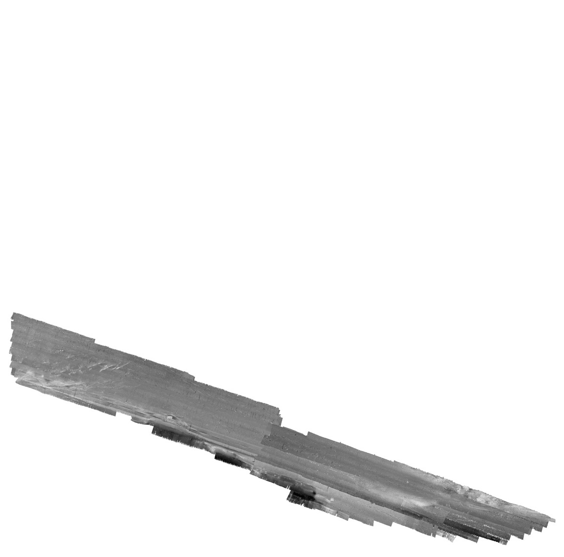
The acoustic-backscatter map of the Offshore of Coal Oil Point map area, California, was generated from backscatter data collected by California State University, Monterey Bay, Seafloor Mapping Lab (CSUMB), by the U.S. Geological Survey (USGS), and by Fugro Pelagos. This metadata describes the acoustic-backscatter data collected by Fugro Pelagos and reprocessed by CSUMB. See "BackscatterA_CSUMB_OffshoreCoalOilPoint_metadata.txt" metadata for a description of the acoustic-backscatter data collected by CSUMB, and see "BackscatterB_USGS_OffshoreCoalOilPoint_metadata.txt" metadata for a description of the acoustic-backscatter data collected by the USGS. Fugro Pelagos collected backscatter data offshore the Coal Oil Point region in 2008 using a combination of several sonars (400-kHz Reson 7125, 240-kHz Reson 8101, 100-kHz Reson 8111) aboard a series of Fugro Pelagos-directed vessels. An Applanix POS MV (Position and Orientation System for Marine Vessels) was used to accurately position the vessels during data collection, and it also accounted for vessel motion such as heave, pitch, and roll (position accuracy, +/-2 m; pitch, roll, and heading accuracy, +/-0.02 degrees; heave accuracy, +/-5 percent, or 5 cm). KGPS (GPS with real-time kinematic corrections) altitude data were used to account for tide-cycle fluctuations, and sound-velocity profiles were collected with an Applied Microsystems SVPlus sound velocimeter. Data were cleaned, and final products were created by the Seafloor Mapping Lab at CSUMB from the postprocessed multibeam-bathymetry data. Within the acoustic-backscatter imagery, brighter tones indicate higher backscatter intensity, and darker tones indicate lower backscatter intensity. The intensity represents a complex interaction between the acoustic pulse and the seafloor, as well as characteristics within the shallow subsurface, providing a general indication of seafloor texture and sediment type. Backscatter intensity depends on the acoustic source level; the frequency used to image the seafloor; the grazing angle; the composition and character of the seafloor, including grain size, water content, bulk density, and seafloor roughness; and some biological cover. Harder and rougher bottom types such as rocky outcrops or coarse sediment typically return stronger intensities (high backscatter, lighter tones), whereas softer bottom types such as fine sediment return weaker intensities (low backscatter, darker tones).
Purpose:
To expand geologic mapping to the seafloor within the California's State Waters, to update coastal geologic mapping, and to contribute to a uniform regional geologic database, which can be used geographic information systems. Additionally, to provide a geologic map for the public and geoscience community to aid in assessments and mitigation of geologic hazards in the Coal Oil Point coastal region and to provide sufficient geologic information for land-use and land-management decisions both onshore and offshore. These data are intended for science researchers, students, policy makers, and the general public. These data can be used with geographic information systems or other software. This information is not intended for navigational purposes.
Supplemental_Information:
Any use of trade, product, or firm names is for descriptive purposes only and does not imply endorsement by the U.S. Government.
Although this Federal Geographic Data Committee-compliant metadata file is intended to document the data set in nonproprietary form, as well as in Esri format, this metadata file may include some Esri-specific terminology.
Time_Period_of_Content:
Time_Period_Information:
Range_of_Dates/Times:
Beginning_Date: 2008
Ending_Date: 2008
Currentness_Reference: ground condition
Status:
Progress: Complete
Maintenance_and_Update_Frequency: As needed
Spatial_Domain:
Bounding_Coordinates:
West_Bounding_Coordinate: -120.001373
East_Bounding_Coordinate: -119.862082
North_Bounding_Coordinate: 34.430114
South_Bounding_Coordinate: 34.365572
Keywords:
Theme:
Theme_Keyword_Thesaurus: USGS Metadata Identifier
Theme_Keyword: USGS:220e59ad-9d6a-473c-b544-65030fcde57f
Theme:
Theme_Keyword_Thesaurus: Global Change Master Directory (GCMD)
Theme_Keyword: Acoustic Reflectivity
Theme:
Theme_Keyword_Thesaurus: ISO 19115 Topic Category
Theme_Keyword: geoscientificInformation
Theme_Keyword: environment
Theme_Keyword: oceans
Theme_Keyword: imageryBaseMapsEarthCover
Theme:
Theme_Keyword_Thesaurus: None
Theme_Keyword: U.S. Geological Survey
Theme_Keyword: USGS
Theme_Keyword: Coastal and Marine Hazards and Resources
Theme_Keyword: CMHRP
Theme_Keyword: Pacific Coastal and Marine Science Center
Theme_Keyword: PCMSC
Theme:
Theme_Keyword_Thesaurus: Data Categories for Marine Planning
Theme_Keyword: distributions
Theme_Keyword: physical habitats and geomorphology
Theme:
Theme_Keyword_Thesaurus: Marine Realms Information Bank (MRIB) keywords
Theme_Keyword: seabed
Theme_Keyword: sidescan sonar
Theme_Keyword: marine geophysics
Theme:
Theme_Keyword_Thesaurus: USGS Thesaurus
Theme_Keyword: sidescan sonar
Theme_Keyword: image mosaics
Theme_Keyword: marine geophysics
Theme_Keyword: sea-floor characteristics
Theme_Keyword: sea-floor acoustic reflectivity
Theme:
Theme_Keyword_Thesaurus: Coastal and Marine Ecological Classification Standard (CMECS)
Theme_Keyword: Marine Nearshore Subtidal
Theme_Keyword: Marine Offshore Subtidal
Theme_Keyword: Transform Continental Margin
Theme_Keyword: Bight
Theme_Keyword: Borderland
Theme_Keyword: Continental/Island Shelf
Theme_Keyword: Rock Substrate
Theme_Keyword: Unconsolidated Mineral Substrate
Place:
Place_Keyword_Thesaurus: Geographic Names Information System (GNIS)
Place_Keyword: Pacific Ocean
Place_Keyword: California
Place_Keyword: Santa Barbara Channel
Place_Keyword: Santa Barbara County
Place_Keyword: Coal Oil Point
Place_Keyword: Goleta
Place_Keyword: Isla Vista
Place:
Place_Keyword_Thesaurus: Coastal and Marine Ecological Classification Standard (CMECS)
Place_Keyword: Southern California Bight Ecoregion
Stratum:
Stratum_Keyword_Thesaurus: Coastal and Marine Ecological Classification Standard (CMECS)
Stratum_Keyword: Substrate
Access_Constraints: None
Use_Constraints:
USGS-authored or produced data and information are in the public domain from the U.S. Government and are freely redistributable with proper metadata and source attribution. Please recognize and acknowledge the U.S. Geological Survey, California State University, Monterey Bay, Seafloor Mapping Lab (CSUMB), and Fugro Pelagros as the originator(s) of the dataset and in products derived from these data. This information is not intended for navigation purposes.
Point_of_Contact:
Contact_Information:
Contact_Organization_Primary:
Contact_Organization:
U.S. Geological Survey, Pacific Coastal and Marine Science Center
Contact_Person: PCMSC Science Data Coordinator
Contact_Address:
Address_Type: mailing and physical
Address: 2885 Mission Street
City: Santa Cruz
State_or_Province: CA
Postal_Code: 95060-5792
Country: US
Contact_Voice_Telephone: 831-427-4747
Contact_Electronic_Mail_Address: pcmsc_data@usgs.gov
Browse_Graphic:
Browse_Graphic_File_Name: Browse_Graphic_File_Description:
Acoustic backscatter imagery of the Offshore of Coal Oil Point map area.
Browse_Graphic_File_Type: JPEG
Native_Data_Set_Environment:
Microsoft Windows Server 2008 R2 Version 6.1 (Build 7601) Service Pack 1; ESRI ArcCatalog 10.0
Cross_Reference:
Citation_Information:
Originator: Samuel Y. Johnson
Originator: Peter Dartnell
Originator: Guy R. Cochrane
Originator: Nadine E. Golden
Originator: Eleyne L. Phillips
Originator: Andrew C. Ritchie
Originator: Rikk G. Kvitek
Originator: Bryan E. Dieter
Originator: James E. Conrad
Originator: Thomas D. Lorenson
Originator: Lisa M. Krigsman
Originator: H. Gary Greene
Originator: Charles A. Endris
Originator: Gordon G. Seitz
Originator: David P. Finlayson
Originator: Ray W. Sliter
Originator: Florence L. Wong
Originator: Mercedes D. Erdey
Originator: Carlos I. Gutierrez
Originator: Ira Leifer
Originator: Mary M. Yoklavich
Originator: Amy E. East
Originator: Patrick E. Hart
Originator: Frances D. Hostettler
Originator: Kenneth E. Peters
Originator: Keith A. Kvenvolden
Originator: Robert J. Rosenbauer
Originator: Grace Fong
Publication_Date: 2014
Title:
California State Waters Map Series--Offshore of Coal Oil Point, California
Geospatial_Data_Presentation_Form: pamphlet and map sheets
Series_Information:
Series_Name: Scientific Investigations Map
Issue_Identification: SIM 3302
Publication_Information:
Publication_Place: Reston, VA
Publisher: U.S. Geological Survey
Online_Linkage: https://doi.org/10.3133/sim3302
Data_Quality_Information:
Attribute_Accuracy:
Attribute_Accuracy_Report: Not applicable for raster data.
Logical_Consistency_Report: Unspecified
Completeness_Report: Complete
Positional_Accuracy:
Horizontal_Positional_Accuracy:
Horizontal_Positional_Accuracy_Report:
Estimated to be no less than 2 m, owing to water depth and total propagated uncertainties of the mapping systems, which include sonar system, position and motion compensation system, and navigation, as well as data processing that includes sounding cleaning, gridding, and datum transformations.
Vertical_Positional_Accuracy:
Vertical_Positional_Accuracy_Report: Not applicable
Lineage:
Process_Step:
Process_Description:
Fugro provided the backscatter (sidescan) data as composite images. Data were processed using GEOCODER (created by Luciano Fonseca; Fugro Pelagos Modified Test Release 16). Within Geocoder, the backscatter intensities were radiometrically corrected (including despeckling and angle varying gain adjustments) and the position of each acoustic sample was geometrically corrected for slant-range. Individual lines were mosaicked to produce a 0.5 m resolution image.
Process_Date: 2008
Process_Contact:
Contact_Information:
Contact_Person_Primary:
Contact_Person: Carrie Bretz
Contact_Organization: Seafloor Mapping Lab, California State University Monterey Bay
Contact_Position: Projects Manager, GIS; Metadata Supervisor
Contact_Address:
Address_Type: mailing and physical address
Address: 100 Campus Center, Bldg 13
City: Seaside
State_or_Province: CA
Postal_Code: 93955
Country: USA
Contact_Voice_Telephone: (831) 582-4197
Contact_Electronic_Mail_Address: carrie_bretz@csumb.edu
Process_Step:
Process_Description:
USGS downloaded the original backscatter images from CSUMB, Seafloor Mapping website at http://seafloor.otterlabs.org/index.html (survey ID H11950). Images were converted to GIS GRIDs and downsampled to 2-m spatial resolution.
Process_Date: 2012
Process_Contact:
Contact_Information:
Contact_Person_Primary:
Contact_Person: Pete Dartnell
Contact_Organization:
U.S. Geological Survey, Pacific Coastal and Marine Science Center
Contact_Position: Physical Scientist
Contact_Address:
Address_Type: mailing and physical address
Address: 2885 Mission St.
City: Santa Cruz
State_or_Province: CA
Postal_Code: 95060-5792
Country: USA
Contact_Voice_Telephone: (831) 460-7415
Contact_Electronic_Mail_Address: pdartnell@usgs.gov
Process_Step:
Process_Description:
Added Distribution_Information section to metadata to facilitate data download.
Process_Date: 20171005
Process_Contact:
Contact_Information:
Contact_Organization_Primary:
Contact_Organization: U.S. Geological Survey
Contact_Person: Alan O. Allwardt
Contact_Position: Contractor -- Information Specialist
Contact_Address:
Address_Type: mailing and physical address
Address: 2885 Mission Street
City: Santa Cruz
State_or_Province: CA
Postal_Code: 95060
Contact_Voice_Telephone: 831-460-7551
Contact_Facsimile_Telephone: 831-427-4748
Contact_Electronic_Mail_Address: aallwardt@usgs.gov
Process_Step:
Process_Description:
Keywords section of metadata optimized for discovery in USGS Coastal and Marine Geology Data Catalog.
Process_Date: 20171005
Process_Contact:
Contact_Information:
Contact_Organization_Primary:
Contact_Organization: U.S. Geological Survey
Contact_Person: Alan O. Allwardt
Contact_Position: Contractor -- Information Specialist
Contact_Address:
Address_Type: mailing and physical address
Address: 2885 Mission Street
City: Santa Cruz
State_or_Province: CA
Postal_Code: 95060
Contact_Voice_Telephone: 831-460-7551
Contact_Facsimile_Telephone: 831-427-4748
Contact_Electronic_Mail_Address: aallwardt@usgs.gov
Process_Step:
Process_Description:
Added keywords from Coastal and Marine Ecological Classification Standard (CMECS) to metadata.
Process_Date: 20180426
Process_Contact:
Contact_Information:
Contact_Organization_Primary:
Contact_Organization: U.S. Geological Survey
Contact_Person: Alan O. Allwardt
Contact_Position: Contractor -- Information Specialist
Contact_Address:
Address_Type: mailing and physical address
Address: 2885 Mission Street
City: Santa Cruz
State_or_Province: CA
Postal_Code: 95060
Contact_Voice_Telephone: 831-460-7551
Contact_Facsimile_Telephone: 831-427-4748
Contact_Electronic_Mail_Address: aallwardt@usgs.gov
Process_Step:
Process_Description:
Edited metadata to add keywords section with USGS persistent identifier as theme keyword. No data were changed.
Process_Date: 20201019
Process_Contact:
Contact_Information:
Contact_Organization_Primary:
Contact_Organization: U.S. Geological Survey
Contact_Person: VeeAnn A. Cross
Contact_Position: Marine Geologist
Contact_Address:
Address_Type: Mailing and Physical
Address: 384 Woods Hole Road
City: Woods Hole
State_or_Province: MA
Postal_Code: 02543-1598
Contact_Voice_Telephone: 508-548-8700 x2251
Contact_Facsimile_Telephone: 508-457-2310
Contact_Electronic_Mail_Address: vatnipp@usgs.gov
Process_Step:
Process_Description:
Performed minor edits to the metadata to correct typos. No data were changed
Process_Date: 20211014
Process_Contact:
Contact_Information:
Contact_Organization_Primary:
Contact_Organization: U.S. Geological Survey
Contact_Person: Susan A. Cochran
Contact_Position: Geologist
Contact_Address:
Address_Type: Mailing and Physical
Address: 2885 Mission Street
City: Santa Cruz
State_or_Province: CA
Postal_Code: 95060
Contact_Voice_Telephone: 831-460-7545
Contact_Electronic_Mail_Address: scochran@usgs.gov
Process_Step:
Process_Description:
Metadata was modified to bring up to current USGS PCMSC standards. USGS Thesaurus and keywords were added, information for accompanying Open-File Report added to Abstract and Cross Reference sections, Point of Contact and Metadata Contact information was updated, and Process Steps were refined. Information about the data available for download and different Network Resource Name links and details were given in the Standard Order Process section. Minor typos were corrected. No data information was changed. The metadata available from a harvester may supersede metadata bundled within a download file. Users are advised to compare the metadata dates to determine which metadata file is most recent.
Process_Date: 20230316
Process_Contact:
Contact_Information:
Contact_Person_Primary:
Contact_Person: Susan A Cochran
Contact_Organization:
U.S. Geological Survey, Pacific Coastal and Marine Science Center
Contact_Position: Geologist
Contact_Address:
Address_Type: mailing and physical address
Address: 2885 Mission Street
City: Santa Cruz
State_or_Province: CA
Postal_Code: 95060-5792
Country: USA
Contact_Voice_Telephone: (831) 460-7545
Contact_Electronic_Mail_Address: scochran@usgs.gov
Spatial_Data_Organization_Information:
Direct_Spatial_Reference_Method: Raster
Raster_Object_Information:
Raster_Object_Type: Grid Cell
Spatial_Reference_Information:
Horizontal_Coordinate_System_Definition:
Planar:
Grid_Coordinate_System:
Grid_Coordinate_System_Name: Universal Transverse Mercator
Universal_Transverse_Mercator:
UTM_Zone_Number: 11
Transverse_Mercator:
Scale_Factor_at_Central_Meridian: 0.9996
Longitude_of_Central_Meridian: -117.00000
Latitude_of_Projection_Origin: 0.00000
False_Easting: 500000.0
False_Northing: 0.00
Planar_Coordinate_Information:
Planar_Coordinate_Encoding_Method: coordinate pair
Coordinate_Representation:
Abscissa_Resolution: 2.0
Ordinate_Resolution: 2.0
Planar_Distance_Units: Meters
Geodetic_Model:
Horizontal_Datum_Name: WGS84
Ellipsoid_Name: NAVD88
Semi-major_Axis: 6378137.00
Denominator_of_Flattening_Ratio: 298.257223563
Entity_and_Attribute_Information:
Overview_Description:
Entity_and_Attribute_Overview:
The complete Fugro backscatter data were originally archived as an ESRI grid with the following attributes:
Cell size = 2.0
Number of rows = 8960
Number of columns = 8963

Data type = floating point

Boundary
Xmin = 223875.0
Xmax = 241801.0
Ymin = 3803500.0
Ymax = 3821420.0

Statistics
Minimum value = 0.0
Maximum value = 237.95
Mean = 104.39
Standard deviation = 21.75

Coordinate system description
Projection  UTM
Zone  11
Datum  WGS84
Units  meter
Entity_and_Attribute_Detail_Citation: none
Distribution_Information:
Distributor:
Contact_Information:
Contact_Organization_Primary:
Contact_Organization: U.S. Geological Survey
Contact_Address:
Address_Type: mailing and physical address
Address: 345 Middlefield Rd
City: Menlo Park
State_or_Province: CA
Postal_Code: 94025-3561
Country: USA
Contact_Voice_Telephone: (650) 329-4309
Resource_Description:
The .zip file (https://pubs.usgs.gov/ds/781/OffshoreCoalOilPoint/data/BackscatterC_Fugro_OffshoreCoalOilPoint.zip) includes the .tfw, .tif, .tif.aux.xml, and .tif.ovr, files, as well as FGDC-compliant metadata for the BackscatterC_Fugro data layer in the Offshore of Coal Oil Point map area of California.
Distribution_Liability:
Unless otherwise stated, all data, metadata and related materials are considered to satisfy the quality standards relative to the purpose for which the data were collected. Although these data and associated metadata have been reviewed for accuracy and completeness and approved for release by the U.S. Geological Survey (USGS), no warranty expressed or implied is made regarding the display or utility of the data on any other system or for general or scientific purposes, nor shall the act of distribution constitute any such warranty.
Standard_Order_Process:
Digital_Form:
Digital_Transfer_Information:
Format_Name: GeoTiff
Format_Version_Number: ArcMap (version 10.0, ESRI, 2011)
Format_Specification:
Raster data layer is registered TIFF image in the UTM Zone 10 coordinate system.
Format_Information_Content:
The .zip file for the TIFF image includes the image (.tif), the world registration file (.tfw), and FGDC-compliant metadata.
File_Decompression_Technique: WinZip
Transfer_Size: 32.7
Digital_Transfer_Option:
Online_Option:
Computer_Contact_Information: Access_Instructions:
The first link will begin a direct download of the data. The second link is a landing page on which all of the downloadable data for a particular region are listed. The third link is a landing page for the entire data catalog.
Fees: none
Metadata_Reference_Information:
Metadata_Date: 20230316
Metadata_Contact:
Contact_Information:
Contact_Organization_Primary:
Contact_Organization:
U.S. Geological Survey, Pacific Coastal and Marine Science Center
Contact_Person: PCMSC Science Data Coordinator
Contact_Address:
Address_Type: mailing and physical
Address: 2885 Mission Street
City: Santa Cruz
State_or_Province: CA
Postal_Code: 95060-5792
Country: US
Contact_Voice_Telephone: 831-427-4747
Contact_Electronic_Mail_Address: pcmsc_data@usgs.gov
Metadata_Standard_Name: Content Standard for Digital Geospatial Metadata
Metadata_Standard_Version: FGDC-STD-001-1998
Metadata_Time_Convention: local time

This page is <https://cmgds.marine.usgs.gov/catalog/pcmsc/SeriesReports/DS_DDS/DS_781/CoalOilPoint/BackscatterC_Fugro_OffshoreCoalOilPoint_metadata.html>
Generated by mp version 2.9.51 on Tue Mar 21 18:02:05 2023