Contours Offshore of Point Reyes Map Map Area, California

Metadata also available as - [Questions & Answers] - [Parseable text] - [XML]

Metadata:

Identification_Information:
Citation:
Citation_Information:
Originator: Peter Dartnell
Originator: Rikk G. Kvitek
Publication_Date: 2014
Title: Contours Offshore of Point Reyes Map Map Area, California
Edition: Version 1.0
Geospatial_Data_Presentation_Form: vector digital data
Series_Information:
Series_Name: Data Series
Issue_Identification: DS 781
Publication_Information:
Publication_Place: Reston, VA
Publisher: U.S. Geological Survey
Online_Linkage: https://doi.org/10.3133/ds781
Online_Linkage: Larger_Work_Citation:
Citation_Information:
Originator: Nadine E. Golden
Publication_Date: 2013
Title: California State Waters Map Series Data Catalog
Geospatial_Data_Presentation_Form: database
Series_Information:
Series_Name: Data Series
Issue_Identification: DS 781
Publication_Information:
Publication_Place: Reston, VA
Publisher: U.S. Geological Survey
Online_Linkage: https://doi.org/10.3133/ds781
Description:
Abstract:
This part of DS 781 presents data for the bathymetric contours for several seafloor maps of the Offshore of Point Reyes map area, California. The vector data file is included in "Contours_PointReyes.zip," which is accessible from https://pubs.usgs.gov/ds/781/OffshorePointReyes/data_catalog_PointReyes.html. These data accompany the pamphlet and map sheets of Watt, J.T., Dartnell, P., Golden, N.E., Greene, H.G., Erdey, M.D., Cochrane, G.R., Johnson, S.Y., Hartwell, S.R., Kvitek, R.G., Manson, M.W., Endris, C.A., Dieter, B.E., Sliter, R.W., Krigsman, L.M., Lowe, E.N., and Chin, J.L. (J.T. Watt and S.A. Cochran, eds.), 2015, California State Waters Map Series—Offshore of Point Reyes, California: U.S. Geological Survey Open-File Report 2015–1114, pamphlet 39 p., 10 sheets, scale 1:24,000, https://doi.org/10.3133/ofr20151114.
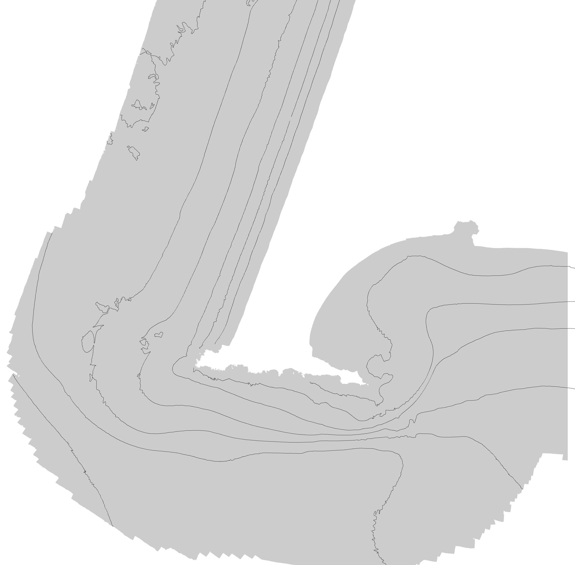
10-m interval contours of the Offshore of Point Reyes map area, California, were generated from bathymetry data collected by California State University, Monterey Bay (CSUMB) and by Fugro Pelagos. Mapping was completed between 2007 and 2010, using a combination of 200-kHz and 400-kHz Reson 7125, and 244-kHz Reson 8101 multibeam echosounders, as well as 468-kHz SEA SWATHPlus interferometric system. These mapping missions combined to collect bathymetry from about the 10-m isobath to beyond the 3-nautical-mile limit of California's State Waters. Bathymetric contours at 10-m intervals were generated from a bathymetric surface model. The most continuous contour segments were preserved while smaller segments and isolated island polygons were excluded from the final output. Contours were smoothed via a polynomial approximation with exponential kernel (PAEK) algorithm using a tolerance value of 60 m. The contours were then clipped to the boundary of the map area. These data are not intended for navigational purposes.
Purpose:
To expand geologic mapping to the seafloor within the California's State Waters, to update coastal geologic mapping, and to contribute to a uniform regional geologic database, which can be used geographic information systems. Additionally, to provide a geologic map for the public and geoscience community to aid in assessments and mitigation of geologic hazards in the Point Reyes coastal region and to provide sufficient geologic information for land-use and land-management decisions both onshore and offshore. These data are intended for science researchers, students, policy makers, and the general public. These data can be used with geographic information systems or other software. This information is not intended for navigational purposes.
Supplemental_Information:
Any use of trade, product, or firm names is for descriptive purposes only and does not imply endorsement by the U.S. Government.
Although this Federal Geographic Data Committee-compliant metadata file is intended to document the data set in nonproprietary form, as well as in Esri format, this metadata file may include some Esri-specific terminology.
Time_Period_of_Content:
Time_Period_Information:
Range_of_Dates/Times:
Beginning_Date: 2007
Ending_Date: 2010
Currentness_Reference: ground condition
Status:
Progress: Complete
Maintenance_and_Update_Frequency: none planned
Spatial_Domain:
Bounding_Coordinates:
West_Bounding_Coordinate: -123.09
East_Bounding_Coordinate: -122.89
North_Bounding_Coordinate: 38.10
South_Bounding_Coordinate: 37.94
Keywords:
Theme:
Theme_Keyword_Thesaurus: USGS Metadata Identifier
Theme_Keyword: USGS:b577c85c-1405-4e73-991c-9d9dce33870b
Theme:
Theme_Keyword_Thesaurus: Global Change Master Directory (GCMD)
Theme_Keyword: Bathymetry
Theme_Keyword: Seafloor Topography
Theme:
Theme_Keyword_Thesaurus: ISO 19115 Topic Category
Theme_Keyword: geoscientificInformation
Theme_Keyword: environment
Theme_Keyword: oceans
Theme_Keyword: imageryBaseMapsEarthCover
Theme:
Theme_Keyword_Thesaurus: Data Categories for Marine Planning
Theme_Keyword: distributions
Theme_Keyword: bathymetry and elevation
Theme:
Theme_Keyword_Thesaurus: USGS Thesaurus
Theme_Keyword: bathymetry
Theme_Keyword: topographic maps
Theme_Keyword: maps and atlases
Theme_Keyword: geospatial datasets
Theme:
Theme_Keyword_Thesaurus: None
Theme_Keyword: U.S. Geological Survey
Theme_Keyword: USGS
Theme_Keyword: Coastal and Marine Hazards and Resources Program
Theme_Keyword: CMHRP
Theme_Keyword: Pacific Coastal and Marine Science Center
Theme_Keyword: PCMSC
Theme:
Theme_Keyword_Thesaurus: Coastal and Marine Ecological Classification Standard (CMECS)
Theme_Keyword: Marine Nearshore Subtidal
Theme_Keyword: Marine Offshore Subtidal
Theme_Keyword: Transform Continental Margin
Theme_Keyword: Continental/Island Shelf
Theme_Keyword: Rock Substrate
Theme_Keyword: Unconsolidated Mineral Substrate
Place:
Place_Keyword_Thesaurus: Geographic Names Information System (GNIS)
Place_Keyword: Pacific Ocean
Place_Keyword: State of California
Place_Keyword: Point Reyes
Place_Keyword: Drakes Bay
Place_Keyword: Marin County
Place_Keyword: Drakes Estero
Place:
Place_Keyword_Thesaurus: Coastal and Marine Ecological Classification Standard (CMECS)
Place_Keyword: Northern California Ecoregion
Stratum:
Stratum_Keyword_Thesaurus: Coastal and Marine Ecological Classification Standard (CMECS)
Stratum_Keyword: Substrate
Access_Constraints: None
Use_Constraints:
USGS-authored or produced data and information are in the public domain from the U.S. Government and are freely redistributable with proper metadata and source attribution. Please recognize and acknowledge the U.S. Geological Survey and California State University, Monterey Bay (CSUMB) as the originator(s) of the dataset and in products derived from these data. This information is not intended for navigation purposes.
Point_of_Contact:
Contact_Information:
Contact_Organization_Primary:
Contact_Organization:
U.S. Geological Survey, Pacific Coastal and Marine Science Center
Contact_Person: PCMSC Science Data Coordinator
Contact_Address:
Address_Type: mailing and physical
Address: 2885 Mission Street
City: Santa Cruz
State_or_Province: CA
Postal_Code: 95060-5792
Country: US
Contact_Voice_Telephone: 831-427-4747
Contact_Electronic_Mail_Address: pcmsc_data@usgs.gov
Browse_Graphic:
Browse_Graphic_File_Name: Browse_Graphic_File_Description:
Bathymetry contour lines of the Offshore of Point Reyes map area.
Browse_Graphic_File_Type: JPEG
Native_Data_Set_Environment:
Microsoft Windows Server 2008 R2 Version 6.1 (Build 7601) Service Pack 1; ESRI ArcCatalog 10.0
Cross_Reference:
Citation_Information:
Originator: Janet T. Watt
Originator: Peter Dartnell
Originator: Nadine E. Golden
Originator: H. Gary Greene
Originator: Mercedes D. Erdey
Originator: Guy R. Cochrane
Originator: Samuel Y. Johnson
Originator: Stephen R. Hartwell
Originator: Rikk G. Kvitek
Originator: Michael W. Manson
Originator: Charles A. Endris
Originator: Bryan E. Dieter
Originator: Ray W. Sliter
Originator: Lisa M. Krigsman
Originator: Eric N. Lowe
Originator: John L. Chin
Publication_Date: 2015
Title:
California State Waters Map Series--Offshore of Point Reyes, California
Geospatial_Data_Presentation_Form: pamphlet and map sheets
Series_Information:
Series_Name: Open-File Report
Issue_Identification: 2015-1114
Publication_Information:
Publication_Place: Reston, VA
Publisher: U.S. Geological Survey
Online_Linkage: https://doi.org/10.3133/ofr20151114
Data_Quality_Information:
Attribute_Accuracy:
Attribute_Accuracy_Report: Not applicable
Logical_Consistency_Report: Unspecified
Completeness_Report: Complete
Positional_Accuracy:
Horizontal_Positional_Accuracy:
Horizontal_Positional_Accuracy_Report:
Estimated to be no less than 2 m, owing to water depth and total propagated uncertainties of the mapping systems, which include sonar system, position and motion compensation system, and navigation, as well as data processing that includes sounding cleaning, gridding, and datum transformations.
Vertical_Positional_Accuracy:
Vertical_Positional_Accuracy_Report:
Estimated to be no less than 20 cm, owing to water depth and total propagated uncertainties of the mapping systems, which include sonar system, position and motion compensation system, and navigation, as well as data processing that includes sounding cleaning, gridding, and datum transformations.
Lineage:
Process_Step:
Process_Description:
During the Fugro Pelagos and CSUMB mapping missions, an Applanix Position and Motion Compensation System for Marine Vessels (POS/MV, 320, v4) was used to accurately position the vessels during data collection, and it also accounted for vessel's motion such as heave, pitch, and roll (position accuracy, +/-2 m; pitch, roll, and heading accuracy, +/-0.02; heave accuracy, +/-5 percent, or 5 cm). KGPS altitude data (Fugro Pelagos, StarFix HP & XP units; CSUMB, NavCom 2050) were used to account for tide cycle fluctuations and sound velocity profiles were collected with an Applied Microsystems SVPlus sound velocimeter. Soundings were corrected for vessel motion using the Applanix POS/MV data, for variations in water-column sound velocity using the AM SVPlus data, and for variations in water height (tides) using vertical-position data from the KGPS receivers.
Process_Date: 2010
Process_Contact:
Contact_Information:
Contact_Person_Primary:
Contact_Person: Carrie Bretz
Contact_Organization: Seafloor Mapping Lab, California State University Monterey Bay
Contact_Position: Projects Manager, GIS & Metadata Supervisor
Contact_Address:
Address_Type: mailing and physical address
Address: 100 Campus Center, Bldg 13
City: Seaside
State_or_Province: CA
Postal_Code: 93955
Country: USA
Contact_Voice_Telephone: 831.582.4197
Contact_Electronic_Mail_Address: carrie_bretz@csumb.edu
Process_Step:
Process_Description:
California Seafloor Mapping Project 2-m-resolution bathymetry data within this map were downloaded from http://seafloor.csumb.edu/SFMLwebDATA.htm. Grids were merged together and clipped to the boundary of the map area. Bathymetric contours at 10-m intervals were generated from the bathymetric surface. The most continuous contour segments were preserved while smaller segments and isolated island polygons were excluded from the final output. Contours were smoothed via a polynomial approximation with exponential kernel (PAEK) algorithm using a tolerance value of 60 m.
Process_Date: 2012
Process_Contact:
Contact_Information:
Contact_Person_Primary:
Contact_Person: Pete Dartnell
Contact_Organization:
U.S. Geological Survey, Pacific Coastal and Marine Science Center
Contact_Position: Physical Scientist
Contact_Address:
Address_Type: mailing and physical address
Address: 2885 Mission St.
City: Santa Cruz
State_or_Province: CA
Postal_Code: 95060-5792
Country: USA
Contact_Voice_Telephone: (831) 460-7415
Contact_Electronic_Mail_Address: pdartnell@usgs.gov
Process_Step:
Process_Description:
Modified Distribution_Information section in metadata to facilitate data download.
Process_Date: 20171005
Process_Contact:
Contact_Information:
Contact_Organization_Primary:
Contact_Organization: U.S. Geological Survey
Contact_Person: Alan O. Allwardt
Contact_Position: Contractor -- Information Specialist
Contact_Address:
Address_Type: mailing and physical address
Address: 2885 Mission Street
City: Santa Cruz
State_or_Province: CA
Postal_Code: 95060
Contact_Voice_Telephone: 831-460-7551
Contact_Facsimile_Telephone: 831-427-4748
Contact_Electronic_Mail_Address: aallwardt@usgs.gov
Process_Step:
Process_Description:
Keywords section of metadata optimized for discovery in USGS Coastal and Marine Geology Data Catalog.
Process_Date: 20171005
Process_Contact:
Contact_Information:
Contact_Organization_Primary:
Contact_Organization: U.S. Geological Survey
Contact_Person: Alan O. Allwardt
Contact_Position: Contractor -- Information Specialist
Contact_Address:
Address_Type: mailing and physical address
Address: 2885 Mission Street
City: Santa Cruz
State_or_Province: CA
Postal_Code: 95060
Contact_Voice_Telephone: 831-460-7551
Contact_Facsimile_Telephone: 831-427-4748
Contact_Electronic_Mail_Address: aallwardt@usgs.gov
Process_Step:
Process_Description:
Added keywords from Coastal and Marine Ecological Classification Standard (CMECS) to metadata.
Process_Date: 20180426
Process_Contact:
Contact_Information:
Contact_Organization_Primary:
Contact_Organization: U.S. Geological Survey
Contact_Person: Alan O. Allwardt
Contact_Position: Contractor -- Information Specialist
Contact_Address:
Address_Type: mailing and physical address
Address: 2885 Mission Street
City: Santa Cruz
State_or_Province: CA
Postal_Code: 95060
Contact_Voice_Telephone: 831-460-7551
Contact_Facsimile_Telephone: 831-427-4748
Contact_Electronic_Mail_Address: aallwardt@usgs.gov
Process_Step:
Process_Description:
Edited metadata to add keywords section with USGS persistent identifier as theme keyword. No data were changed.
Process_Date: 20201019
Process_Contact:
Contact_Information:
Contact_Organization_Primary:
Contact_Organization: U.S. Geological Survey
Contact_Person: VeeAnn A. Cross
Contact_Position: Marine Geologist
Contact_Address:
Address_Type: Mailing and Physical
Address: 384 Woods Hole Road
City: Woods Hole
State_or_Province: MA
Postal_Code: 02543-1598
Contact_Voice_Telephone: 508-548-8700 x2251
Contact_Facsimile_Telephone: 508-457-2310
Contact_Electronic_Mail_Address: vatnipp@usgs.gov
Process_Step:
Process_Description:
Metadata was modified to bring up to current USGS PCMSC standards. USGS Thesaurus and keywords were added, information for accompanying Open-File Report added to Abstract and Cross Reference sections, Point of Contact and Metadata Contact information was updated, and Process Steps were refined. Information about the data available for download and different Network Resource Name links and details were given in the Standard Order Process section. Minor typos were corrected. No data information was changed. The metadata available from a harvester may supersede metadata bundled within a download file. Users are advised to compare the metadata dates to determine which metadata file is most recent.
Process_Date: 20230314
Process_Contact:
Contact_Information:
Contact_Person_Primary:
Contact_Person: Susan A Cochran
Contact_Organization:
U.S. Geological Survey, Pacific Coastal and Marine Science Center
Contact_Position: Geologist
Contact_Address:
Address_Type: mailing and physical address
Address: 2885 Mission Street
City: Santa Cruz
State_or_Province: CA
Postal_Code: 95060-5792
Country: USA
Contact_Voice_Telephone: (831) 460-7545
Contact_Electronic_Mail_Address: scochran@usgs.gov
Spatial_Data_Organization_Information:
Direct_Spatial_Reference_Method: Vector
Point_and_Vector_Object_Information:
SDTS_Terms_Description:
SDTS_Point_and_Vector_Object_Type: String
Point_and_Vector_Object_Count: 7
Spatial_Reference_Information:
Horizontal_Coordinate_System_Definition:
Planar:
Grid_Coordinate_System:
Grid_Coordinate_System_Name: Universal Transverse Mercator
Universal_Transverse_Mercator:
UTM_Zone_Number: 10
Transverse_Mercator:
Scale_Factor_at_Central_Meridian: 0.9996
Longitude_of_Central_Meridian: -123.00000
Latitude_of_Projection_Origin: 0.00000
False_Easting: 500000.0
False_Northing: 0.00
Planar_Coordinate_Information:
Planar_Coordinate_Encoding_Method: coordinate pair
Coordinate_Representation:
Abscissa_Resolution: 2.0
Ordinate_Resolution: 2.0
Planar_Distance_Units: Meters
Geodetic_Model:
Horizontal_Datum_Name: NAD83
Ellipsoid_Name: GRS80
Semi-major_Axis: 6378137.00
Denominator_of_Flattening_Ratio: 298.257223563
Entity_and_Attribute_Information:
Detailed_Description:
Entity_Type:
Entity_Type_Label: Contours_PointReyes.shp
Entity_Type_Definition:
The shapefile attributes include FID - Internal Feature Number, SHAPE - feature geometry, ID - feature ID, and CONTOUR - contour depth value. The shapefile can be added to any ESRI ArcMap project.
Entity_Type_Definition_Source: ESRI
Attribute:
Attribute_Label: FID
Attribute_Definition: Internal feature number.
Attribute_Definition_Source: ESRI
Attribute_Domain_Values:
Unrepresentable_Domain:
Sequential unique whole numbers that are automatically generated.
Attribute:
Attribute_Label: SHAPE
Attribute_Definition: Feature geometry
Attribute_Definition_Source: ESRI
Attribute_Domain_Values:
Unrepresentable_Domain: Polyline
Attribute:
Attribute_Label: ID
Attribute_Definition:
Unique identifier for each contour line. Value of 0 means the line segment has been generated during the smoothing process.
Attribute_Definition_Source: ESRI
Attribute_Domain_Values:
Unrepresentable_Domain: Polyline
Attribute:
Attribute_Label: CONTOUR
Attribute_Definition:
Contours are lines that connect points of equal depth based on the bathymetry grid. The contour values indicate the depth value the line represents. This makes it easier to identifier features on the seafloor. Contour lines were generated at 10-m intervals, from -10 m to -70 m, then the contours were clipped to the boundary of the map area. Values are negative to indicate depth below sea level. The value of 0 represents a line segment created during the smoothing process.
Attribute_Definition_Source: USGS
Attribute_Domain_Values:
Range_Domain:
Range_Domain_Minimum: -70
Range_Domain_Maximum: -10
Attribute_Units_of_Measure:
Integer values -10 to -70 representing depth intervals as described above.
Distribution_Information:
Distributor:
Contact_Information:
Contact_Organization_Primary:
Contact_Organization: U.S. Geological Survey
Contact_Address:
Address_Type: mailing and physical address
Address: 345 Middlefield Rd
City: Menlo Park
State_or_Province: CA
Postal_Code: 94025-3561
Country: USA
Contact_Voice_Telephone: (650) 329-4309
Resource_Description:
The .zip file (https://pubs.usgs.gov/ds/781/OffshorePointReyes/data/Contours_OffshorePointReyes.zip) includes the .aux, .dbf, .shp, .shx, .sbx, and .sbn files, as well as FGDC-compliant metadata for the bathymetric contour data layer of Offshore of Point Reyes, California, map area.
Distribution_Liability:
Unless otherwise stated, all data, metadata and related materials are considered to satisfy the quality standards relative to the purpose for which the data were collected. Although these data and associated metadata have been reviewed for accuracy and completeness and approved for release by the U.S. Geological Survey (USGS), no warranty expressed or implied is made regarding the display or utility of the data on any other system or for general or scientific purposes, nor shall the act of distribution constitute any such warranty.
Standard_Order_Process:
Digital_Form:
Digital_Transfer_Information:
Format_Name: shapefile
Format_Version_Number: ArcMap (version 10.0, ESRI, 2011)
Format_Specification:
Point, line, and polygon features are in shapefile format and are projected in UTM Zone 10 coordinates.
Format_Information_Content:
The .zip file includes the .aux, .dbf, .shp, .shx, .sbx, and .sbn files, as well as FGDC-compliant metadata for the bathymetric contour data layer of the Offshore of Point Reyes, California, map area.
File_Decompression_Technique: WinZip
Transfer_Size: 0.3
Digital_Transfer_Option:
Online_Option:
Computer_Contact_Information: Access_Instructions:
The first link will begin a direct download of the data. The second link is a landing page on which all of the downloadable data for a particular region are listed. The third link is a landing page for the entire data catalog.
Fees: none
Metadata_Reference_Information:
Metadata_Date: 20230314
Metadata_Contact:
Contact_Information:
Contact_Organization_Primary:
Contact_Organization:
U.S. Geological Survey, Pacific Coastal and Marine Science Center
Contact_Person: PCMSC Science Data Coordinator
Contact_Address:
Address_Type: mailing and physical
Address: 2885 Mission Street
City: Santa Cruz
State_or_Province: CA
Postal_Code: 95060-5792
Country: US
Contact_Voice_Telephone: 831-427-4747
Contact_Electronic_Mail_Address: pcmsc_data@usgs.gov
Metadata_Standard_Name: Content Standard for Digital Geospatial Metadata
Metadata_Standard_Version: FGDC-STD-001-1998
Metadata_Time_Convention: local time

This page is <https://cmgds.marine.usgs.gov/catalog/pcmsc/SeriesReports/DS_DDS/DS_781/PointReyes/Contours_OffshorePointReyes_metadata.html>
Generated by mp version 2.9.51 on Thu Mar 16 09:55:23 2023