Citation:
Citation_Information:
Originator: John Chin
Originator: A. Graig McHendrie
Originator: Carol Madison
Originator: Florence L. Wong
Publication_Date: 20010327
Title:
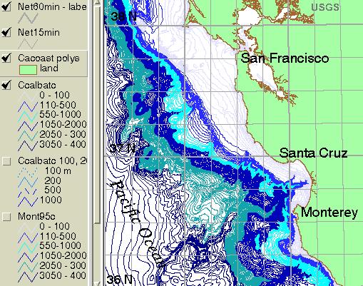
CCALBATC - bathymetric contours for the central California region between Point Arena and Point Sur.
Edition: 1.0
Geospatial_Data_Presentation_Form: vector digital data
Series_Information:
Series_Name: Open-File Report
Issue_Identification: 01-179
Publication_Information:
Publication_Place: Western Coastal and Marine Geology, Menlo Park, CA
Publisher: U.S. Geological Survey, Coastal and Marine Geology Program
Online_Linkage: https://pubs.usgs.gov/of/2001/0179/exp_arc/battopo/ccalbatc.tgz
Online_Linkage: https://doi.org/10.3133/ofr01179
Larger_Work_Citation:
Citation_Information:
Originator: Florence L. Wong
Originator: Stephen E. Eittreim
Publication_Date: 2001
Title:
Continental Shelf GIS for the Monterey Bay National Marine Sanctuary
Edition: 1.1
Series_Information:
Series_Name: Open-File Report
Issue_Identification: 01-179
Publication_Information:
Publication_Place: Western Region Coastal and Marine Geology, Menlo Park, CA
Publisher: U.S. Geological Survey, Coastal and Marine Geology Program
Online_Linkage: https://doi.org/10.3133/ofr01179
Description:
Abstract:
CCALBATC consists of bathymetric contours at 10-m and 50-m intervals for the area offshore of central California between Point Arena to the north and Point Sur to the south. The lines were digitized from 1:250,000-scale NOAA charts. This is one of a collection of digital files of a geographic information system of spatially referenced data related to the USGS Coastal and Marine Geology Program Monterey Bay National Marine Sanctuary Project (see this and other older Monterey Bay USGS works archived at
https://archive.usgs.gov/archive/sites/walrus.wr.usgs.gov/monterey/index.html.
These data are intended for science researchers, students, policy makers, and the general public. The data can be used with geographic information systems (GIS) software to display geologic and oceanographic information about the shallower areas of the Monterey Bay National Marine Sanctuary.
Supplemental_Information:
Any use of trade, product, or firm names is for descriptive purposes only and does not imply endorsement by the U.S. Government.
Although this Federal Geographic Data Committee-compliant metadata file is intended to document the data set in nonproprietary form, as well as in Esri format, this metadata file may include some Esri-specific terminology.
Time_Period_of_Content:
Time_Period_Information:
Single_Date/Time:
Calendar_Date: 1974
Currentness_Reference: ground condition
Status:
Progress: Complete
Maintenance_and_Update_Frequency: none planned
Spatial_Domain:
Bounding_Coordinates:
West_Bounding_Coordinate: -125.194828
East_Bounding_Coordinate: -121.445713
North_Bounding_Coordinate: 39.019944
South_Bounding_Coordinate: 35.981372
Keywords:
Theme:
Theme_Keyword_Thesaurus: USGS Metadata Identifier
Theme_Keyword: USGS:6b2c069c-2d2f-4abe-9726-fddb63747422
Theme:
Theme_Keyword_Thesaurus: ISO 19115 Topic Category
Theme_Keyword: oceans
Theme_Keyword: geoscientificInformation
Theme_Keyword: elevation
Theme:
Theme_Keyword_Thesaurus: Global Change Master Directory (GCMD)
Theme_Keyword: Continental Margins
Theme:
Theme_Keyword_Thesaurus: Data Categories for Marine Planning
Theme_Keyword: Bathymetry and Elevation
Theme:
Theme_Keyword_Thesaurus: Marine Realms Information Bank (MRIB) keywords
Theme_Keyword: continental margin
Theme_Keyword: continental shelf
Theme:
Theme_Keyword_Thesaurus: USGS Thesaurus
Theme_Keyword: bathymetry
Theme_Keyword: geospatial datasets
Theme_Keyword: sea-floor characteristics
Theme_Keyword: contouring
Theme_Keyword: marine geology
Theme:
Theme_Keyword_Thesaurus: None
Theme_Keyword: U.S. Geological Survey
Theme_Keyword: USGS
Theme_Keyword: Coastal and Marine Geology Program
Theme_Keyword: CMGP
Theme_Keyword: Pacific Coastal and Marine Science Center
Theme_Keyword: PCMSC
Theme_Keyword: Coastal Geology
Place:
Place_Keyword_Thesaurus: Geographic Names Information System (GNIS)
Place_Keyword: Pacific Ocean
Place_Keyword: Monterey Bay
Place_Keyword: Point Ano Nuevo
Place_Keyword: Santa Cruz
Place_Keyword: Moss Landing
Place_Keyword: Monterey
Place_Keyword: Point Sur
Place_Keyword: Point Arena
Place_Keyword: United States of America
Place:
Place_Keyword_Thesaurus: None
Place_Keyword: Northern California
Place_Keyword: Monterey Bay National Marine Sanctuary
Place_Keyword: Central California
Place_Keyword: North Pacific Ocean
Place_Keyword: Northern Pacific Ocean
Place_Keyword: USA
Place_Keyword: North America
Access_Constraints: None
Use_Constraints:
USGS-authored or produced data and information are in the public domain from the U.S. Government and are freely redistributable with proper metadata and source attribution. Please recognize and acknowledge the U.S. Geological Survey as the originator(s) of the dataset and in products derived from these data. This information is not intended for navigation purposes.
Point_of_Contact:
Contact_Information:
Contact_Organization_Primary:
Contact_Organization:
U.S. Geological Survey, Pacific Coastal and Marine Science Center
Contact_Person: PCMSC Science Data Coordinator
Contact_Address:
Address_Type: mailing and physical
Address: 2885 Mission Street
City: Santa Cruz
State_or_Province: CA
Postal_Code: 95060-5792
Country: US
Contact_Voice_Telephone: 831-427-4747
Contact_Electronic_Mail_Address: [email protected]
Browse_Graphic:
Native_Data_Set_Environment:
Microsoft Windows XP Version 5.1 (Build 2600) Service Pack 2; ESRI ArcCatalog 9.0.0.535