NOSBATC - bathymetric contour data for the Monterey Bay region from Point Ano Nuevo to Point Sur, California based on NOAA/NOS data (UTM)

Metadata also available as - [Outline] - [Parseable text] - [XML]

Frequently anticipated questions:


What does this data set describe?

Title:
NOSBATC - bathymetric contour data for the Monterey Bay region from Point Ano Nuevo to Point Sur, California based on NOAA/NOS data (UTM)
Abstract:
This dataset contains bathymetric contours for the greater Monterey Bay area between Point Ano Nuevo to the north and Point Sur to the south. Contours are provided at 10-m intervals to a depth of 200 m and 100-m intervals to maximum depth. The data from which the contours were derived were hydrographic survey points published by NOAA NOS in 1998. This is one of a collection of digital files of a geographic information system of spatially referenced data related to the USGS Coastal and Marine Geology Program Monterey Bay National Marine Sanctuary Project (see this and other older Monterey Bay USGS works archived at https://archive.usgs.gov/archive/sites/walrus.wr.usgs.gov/monterey/index.html.
Supplemental_Information:
Any use of trade, product, or firm names is for descriptive purposes only and does not imply endorsement by the U.S. Government.
Although this Federal Geographic Data Committee-compliant metadata file is intended to document the data set in nonproprietary form, as well as in Esri format, this metadata file may include some Esri-specific terminology.
  1. How might this data set be cited?
    Wong, Florence L., Degnan, Carolyn H., and Lee, Wilson C., 2001, NOSBATC - bathymetric contour data for the Monterey Bay region from Point Ano Nuevo to Point Sur, California based on NOAA/NOS data (UTM): Open-File Report 01-179, U.S. Geological Survey, Coastal and Marine Geology Program, Western Coastal and Marine Geology, Menlo Park, CA.

    Online Links:

    This is part of the following larger work.

    Wong, Florence L., and Eittreim, Stephen E., 2001, Continental Shelf GIS for the Monterey Bay National Marine Sanctuary: Open-File Report 01-179, U.S. Geological Survey, Coastal and Marine Geology Program, Western Region Coastal and Marine Geology, Menlo Park, CA.

    Online Links:

  2. What geographic area does the data set cover?
    West_Bounding_Coordinate: -122.456824
    East_Bounding_Coordinate: -121.684160
    North_Bounding_Coordinate: 37.169881
    South_Bounding_Coordinate: 36.164233
  3. What does it look like?
    https://pubs.usgs.gov/of/2001/0179/images/batnos.gif (GIF)
    location map of nosbatc
  4. Does the data set describe conditions during a particular time period?
    Calendar_Date: 1998
    Currentness_Reference:
    ground condition
  5. What is the general form of this data set?
    Geospatial_Data_Presentation_Form: vector digital data
  6. How does the data set represent geographic features?
    1. How are geographic features stored in the data set?
      This is a Vector data set. It contains the following vector data types (SDTS terminology):
      • String (772)
    2. What coordinate system is used to represent geographic features?
      Horizontal positions are specified in geographic coordinates, that is, latitude and longitude. Latitudes are given to the nearest 0.000001. Longitudes are given to the nearest 0.000001. Latitude and longitude values are specified in Decimal degrees. The horizontal datum used is North American Datum of 1983.
      The ellipsoid used is Geodetic Reference System 80.
      The semi-major axis of the ellipsoid used is 6378137.000000.
      The flattening of the ellipsoid used is 1/298.257222.
  7. How does the data set describe geographic features?
    nosbatc
    ArcInfo interchange file containing contour information. (Source: Producer defined)
    FID
    Internal feature number. (Source: ESRI) Sequential unique whole numbers that are automatically generated.
    Shape
    Feature geometry. (Source: ESRI) Coordinates defining the features.
    FNODE_
    Carried over from ArcInfo attribute FNODE_. It is an ArcInfo internal control parameter and has not applicable relevance to the use of the data. (Source: User Defined) Whole numbers that are automatically generated.
    TNODE_
    Carried over from ArcInfo attribute TNODE_. It is an ArcInfo internal control parameter and has not applicable relevance to the use of the data. (Source: User Defined) Whole numbers that are automatically generated.
    LPOLY_
    Carried over from ArcInfo attribute LPOLY_. It is an ArcInfo internal control parameter and has not applicable relevance to the use of the data. (Source: User Defined) Whole numbers that are automatically generated.
    RPOLY_
    Carried over from ArcInfo attribute RPOLY_. It is an ArcInfo internal control parameter and has not applicable relevance to the use of the data. (Source: User Defined) Whole numbers that are automatically generated.
    LENGTH
    Length of vector segment in native units. (Source: User Defined)
    Range of values
    Minimum:0
    Maximum:98619.744026
    NOSBATC_
    Carried over from ArcInfo attribute NOSBATC_. It is an ArcInfo internal control parameter and has not applicable relevance to the use of the data. (Source: User Defined)
    Range of values
    Minimum:1
    Maximum:772
    NOSBATC_ID
    Carried over from ArcInfo attribute NOSBATC_ID. It is an ArcInfo internal control parameter and has not applicable relevance to the use of the data. (Source: User Defined)
    Range of values
    Minimum:1
    Maximum:772
    ELEV_M
    Depth contour values recorded as negative values. (Source: User Defined)
    Range of values
    Minimum:-2900
    Maximum:-10
    Units:meters
    Entity_and_Attribute_Overview:
    NOSBATC is an ArcInfo data set that consists of bathymetric contours whose attributes are described in the database table.
    Entity_and_Attribute_Detail_Citation: none

Who produced the data set?

  1. Who are the originators of the data set? (may include formal authors, digital compilers, and editors)
    • Florence L. Wong
    • Carolyn H. Degnan
    • Wilson C. Lee
  2. Who also contributed to the data set?
  3. To whom should users address questions about the data?
    U.S. Geological Survey, Pacific Coastal and Marine Science Center
    Attn: PCMSC Science Data Coordinator
    2885 Mission Street
    Santa Cruz, CA
    US

    831-427-4747 (voice)
    pcmsc_data@usgs.gov

Why was the data set created?

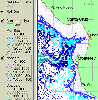
These data are intended for science researchers, students, policy makers, and the general public. The data can be used with geographic information systems (GIS) software to display geologic and oceanographic information about the shallower areas of the Monterey Bay National Marine Sanctuary.

How was the data set created?

  1. From what previous works were the data drawn?
    NOAA (1998) (source 1 of 1)
    NOAA, 1998, NOS Hydrographic Survey Data, US Coastal Waters: Data Announcement 98-MGG-03.

    Online Links:

    Other_Citation_Details: Boulder, CO, World Data Center for Marine Geology & Geophysics
    Type_of_Source_Media: CD-ROM
    Source_Contribution: bathymetric data points
  2. How were the data generated, processed, and modified?
    Date: Nov-1999 (process 1 of 6)
    C.H. Degnan: extracted bathymetry data from NOAA (1998), gridded it in GMT (Wessel and Smith, 1998) with a 2-second grid spacing, and exported the grid values as ASCII xyz coordinates. Data sources produced in this process:
    • nosbatc
    Date: Dec-1999 (process 2 of 6)
    W.C. Lee: converted bathymetry xyz coordinates to ArcInfo point coverage. Created ArcInfo TIN from point coverage; converted TIN to 50-m grid (Arc: TINLATTICE, quintic option).
    Date: Mar-2001 (process 3 of 6)
    F.L. Wong extracted contour coverage NOSBATC from 50-m grid of process date 199912 in 2 parts. Extracted grid with values greater than -300, generated contours at 10-m intervals, and removed contours landward of -10 m and seaward of -200 m. Extracted a second grid with values less than -100, generated contours at 100-m intervals, and removed contours landward of -200 m. Expanded value ranges were used in the extracted grids to produce continuous contours at the target cut-off elevation. Both sets of contours were combined as a new coverage NOSBATC.
    Date: 27-Mar-2001 (process 4 of 6)
    First draft of metadata created by F.L. Wong using a modified version of FGDCMETA.AML on ARC/INFO data set NOSBATC.
    Date: 03-Dec-2019 (process 5 of 6)
    Edits were made to bring the metadata up to current PCMSC standards including standardizing authors' names, adding a doi# link, correcting typos, refining keywords, correcting missing and incomplete tags, and using current access and distribution liability statements. Point of Contact and Metadata Contact information sections were changed to static PCMSC contact information. No data were changed. Users are advised to compare the metadata date of this file to any similar file to ensure they are using the most recent version. Person who carried out this activity:
    Susan A Cochran
    U.S. Geological Survey, Pacific Coastal and Marine Science Center
    2885 Mission St.
    Santa Cruz, CA
    United States

    831-460-7545 (voice)
    scochran@usgs.gov
    Date: 19-Oct-2020 (process 6 of 6)
    Edited metadata to add keywords section with USGS persistent identifier as theme keyword. No data were changed. Person who carried out this activity:
    U.S. Geological Survey
    Attn: VeeAnn A. Cross
    Marine Geologist
    384 Woods Hole Road
    Woods Hole, MA

    508-548-8700 x2251 (voice)
    508-457-2310 (FAX)
    vatnipp@usgs.gov
  3. What similar or related data should the user be aware of?

How reliable are the data; what problems remain in the data set?

  1. How well have the observations been checked?
  2. How accurate are the geographic locations?
  3. How accurate are the heights or depths?
  4. Where are the gaps in the data? What is missing?
    Complete
  5. How consistent are the relationships among the observations, including topology?
    Chain-node topology present.

How can someone get a copy of the data set?

Are there legal restrictions on access or use of the data?
Access_Constraints: None
Use_Constraints:
USGS-authored or produced data and information are in the public domain from the U.S. Government and are freely redistributable with proper metadata and source attribution. Please recognize and acknowledge the U.S. Geological Survey as the originator(s) of the dataset and in products derived from these data. This information is not intended for navigation purposes.
  1. Who distributes the data set? (Distributor 1 of 1)
    United States Geological Survey (USGS)
    Coastal and Marine Geology (CMG)
    Menlo Park, CA
    USA

    (650) 329-5327 (voice)
  2. What's the catalog number I need to order this data set? Downloadable Data
  3. What legal disclaimers am I supposed to read?
    Unless otherwise stated, all data, metadata and related materials are considered to satisfy the quality standards relative to the purpose for which the data were collected. Although these data and associated metadata have been reviewed for accuracy and completeness and approved for release by the U.S. Geological Survey (USGS), no warranty expressed or implied is made regarding the display or utility of the data on any other system or for general or scientific purposes, nor shall the act of distribution constitute any such warranty.
  4. How can I download or order the data?

Who wrote the metadata?

Dates:
Last modified: 19-Oct-2020
Metadata author:
U.S. Geological Survey, Pacific Coastal and Marine Science Center
Attn: PCMSC Science Data Coordinator
2885 Mission Street
Santa Cruz, CA
US

831-427-4747 (voice)
pcmsc_data@usgs.gov
Metadata standard:
Content Standard for Digital Geospatial Metadata (FGDC-STD-001-1998)

This page is <https://cmgds.marine.usgs.gov/catalog/pcmsc/SeriesReports/OFR/OFR_01-179/nosbatc.e00.faq.html>
Generated by mp version 2.9.50 on Wed Oct 13 09:08:57 2021