Citation:
Citation_Information:
Originator: Guy R. Cochrane
Publication_Date: 2001
Title:
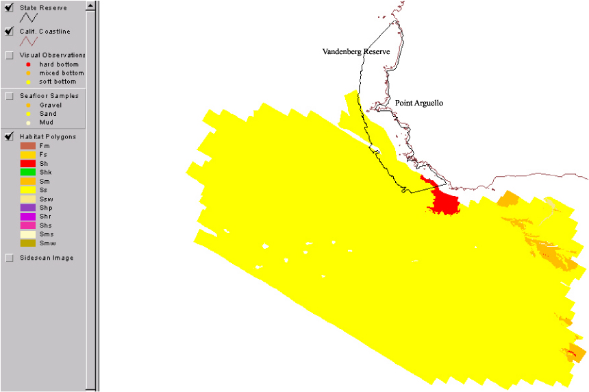
SVANHAB -- Habitat polygons for the nearshore Point Arguello study area, South Vandenberg Reserve
Edition: (Version 1.0, March 07, 2002)
Geospatial_Data_Presentation_Form: vector digital data
Series_Information:
Series_Name: Open-File Report
Issue_Identification: 03-085
Publication_Information:
Publication_Place: Western Coastal and Marine Geology, Menlo Park, CA
Publisher: U.S. Geological Survey, Coastal and Marine Geology Program
Online_Linkage: https://doi.org/10.3133/ofr0385
Larger_Work_Citation:
Citation_Information:
Originator: Guy R. Cochrane
Originator: Nicole M. Nasby
Originator: Jane A. Reid
Originator: Ben Waltenberger
Originator: Kristen Lee
Publication_Date: 2003
Title:
Nearshore Benthic Habitat GIS for the Channel Islands National Marine Santuary and Southern California State Fisheries Reserves, Volume 1
Edition: 1.0
Series_Information:
Series_Name: Open-File Report
Issue_Identification: 03-085
Publication_Information:
Publication_Place: Western Coastal and Marine Geology, Menlo Park, CA
Publisher: U.S. Geological Survey, Coastal and Marine Geology Program
Online_Linkage: https://doi.org/10.3133/ofr0385
Description:
Abstract:
Benthic habitat polygon coverages have been created for marine reserve locations surrounding the Santa Barbara Basin. Diver, ROV and submersible video transects, bathymetry data, sedimentary samples, and sonar mapping, have been integrated to describe the geological, biological, and oceanographic aspects of habitat. The U.S. Geological Survey (USGS), in a cooperative project with Sea Grant-MERRP and investigators at National Marine Fisheries Service (NMFS), the Channel Islands National Marine Sanctuary (CINMS), and National Park Service (NPS) has collected sidescan sonar and video data to produce a polygon coverage. The habitat polygons have attributes for megahabitat, bottom induration, macrohabitat (where macrohabitat observations are available), polygon area, polygon perimeter, and water depth. The habitat GIS shows rocky habitat suitable for rockfish (Sebastes sp.), abalone (Haliotis sp.), and other threatened benthic species from the shoreline out to the 100-m depth limit of the survey.
Purpose:
These data are intended for science researchers, students, policy makers, and the general public. The data can be used with geographic information systems (GIS) software to display geologic and oceanographic information.
Supplemental_Information:
Any use of trade, product, or firm names is for descriptive purposes only and does not imply endorsement by the U.S. Government.
Although this Federal Geographic Data Committee-compliant metadata file is intended to document the data set in nonproprietary form, as well as in ArcInfo format, this metadata file may include some ArcInfo-specific terminology.
Time_Period_of_Content:
Time_Period_Information:
Single_Date/Time:
Calendar_Date: 2002
Currentness_Reference: ground condition
Status:
Progress: In work
Maintenance_and_Update_Frequency: As needed
Spatial_Domain:
Bounding_Coordinates:
West_Bounding_Coordinate: -120.714813
East_Bounding_Coordinate: -120.578331
North_Bounding_Coordinate: 34.582474
South_Bounding_Coordinate: 34.496220
Keywords:
Theme:
Theme_Keyword_Thesaurus: USGS Metadata Identifier
Theme_Keyword: USGS:9e96dcaf-bf9b-48c3-b604-7dd4d0837903
Theme:
Theme_Keyword_Thesaurus: None
Theme_Keyword: U.S. Geological Survey
Theme_Keyword: USGS
Theme_Keyword: Coastal and Marine Geology Program
Theme_Keyword: CMGP
Theme_Keyword: Pacific Coastal and Marine Science Center
Theme_Keyword: PCMSC
Theme_Keyword: Coastal Geology
Theme_Keyword: Marine Geology
Theme_Keyword: habitat
Theme_Keyword: benthic habitat
Theme_Keyword: habitat mapping
Theme_Keyword: nearshore benthic mapping
Theme_Keyword: fisheries
Theme_Keyword: seafloor
Theme_Keyword: geology
Theme_Keyword: interpretive data layer
Theme:
Theme_Keyword_Thesaurus: USGS Thesaurus
Theme_Keyword: habitats
Theme_Keyword: sea-floor characteristics
Theme_Keyword: geospatial datasets
Theme:
Theme_Keyword_Thesaurus: ISO 19115 Topic Category
Theme_Keyword: oceans
Theme_Keyword: biota
Theme_Keyword: geoscientificInformation
Place:
Place_Keyword_Thesaurus: None
Place_Keyword: Point Arguello
Place_Keyword: South Vandenberg Reserve
Place_Keyword: Channel Islands
Place_Keyword: Santa Barbara Basin
Place_Keyword: Santa Barbara
Place_Keyword: Ventura
Place_Keyword: Southern California
Place_Keyword: California
Place_Keyword: CA
Access_Constraints: None
Use_Constraints:
Public domain data from the U.S. Government are freely redistributable with proper metadata and source attribution. Please recognize the U.S. Geological Survey (USGS) as the source of this information.
Point_of_Contact:
Contact_Information:
Contact_Organization_Primary:
Contact_Organization:
U.S. Geological Survey, Pacific Coastal and Marine Science Center
Contact_Person: PCMSC Science Data Coordinator
Contact_Address:
Address_Type: mailing and physical address
Address: 2885 Mission Street
City: Santa Cruz
State_or_Province: CA
Postal_Code: 95060
Country: USA
Contact_Voice_Telephone: 831-427-4747
Contact_Electronic_Mail_Address: [email protected]
Browse_Graphic:
Data_Set_Credit:
Thanks to the Staff of the Channel Islands National Marine Sanctuary,
the crew of the NOAA R/V Ballena, the crew of the NOAA R/V McArthur,
and the crew of the UCSD R/V Sproul.
Native_Data_Set_Environment:
Microsoft Windows XP Version 5.1 (Build 2600) Service Pack 2; ESRI ArcCatalog 9.1.0.722