Citation:
Citation_Information:
Originator: Guy R. Cochrane
Publication_Date: 2002
Title:
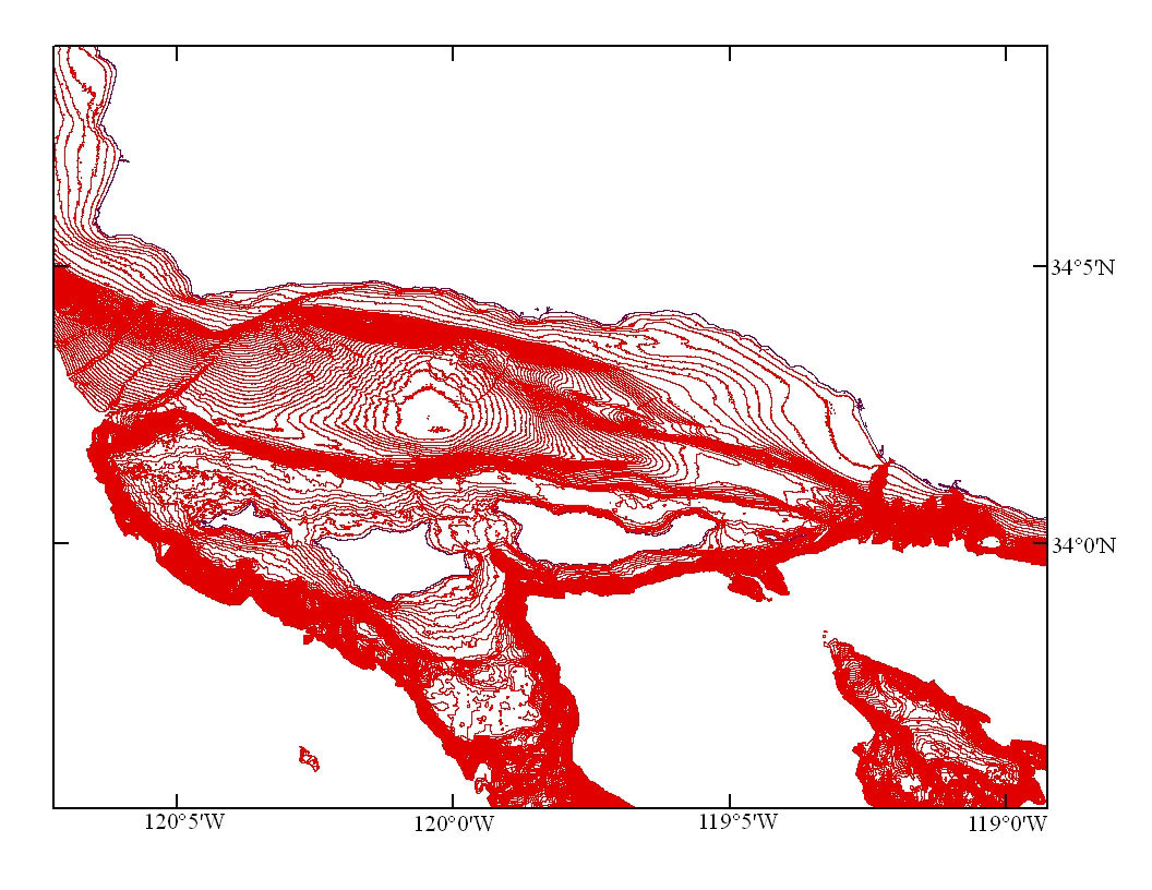
CNTR10M - 10 meter bathymetric contours of the Channel Islands National Marine Sanctuary and Santa Barbara Bay. (UTM 10N, NAD83)
Edition: (Version 1.0, August 09, 2002)
Geospatial_Data_Presentation_Form: vector digital data
Series_Information:
Series_Name: Open-File Report
Issue_Identification: 2005-1170
Publication_Information:
Publication_Place: Pacific Coastal and Marine Science Center, Santa Cruz, CA
Publisher: U.S. Geological Survey
Online_Linkage: http://pubs.usgs.gov/of/2005/1170/basemaps/cntr10m.tgz
Online_Linkage: http://pubs.usgs.gov/of/2005/1170/catalog.html
Online_Linkage: https://doi.org/10.3133/ofr20051170
Larger_Work_Citation:
Citation_Information:
Originator: Guy R. Cochrane
Originator: James E. Conrad
Originator: Jane A. Reid
Originator: Sarah Fangman
Originator: Nadine Golden
Publication_Date: 2005
Title:
Nearshore Benthic Habitat GIS for the Channel Islands National Marine Sanctuary and Southern California State Fisheries Reserves, Volume II Edition: 1.0
Edition: 1.0
Series_Information:
Series_Name: Open-File Report
Issue_Identification: 2005-1170
Publication_Information:
Publication_Place: Pacific Coastal and Marine Science Center, Santa Cruz, CA
Publisher: U.S. Geological Survey
Online_Linkage: https://doi.org/10.3133/ofr20051170
Description:
Abstract:
Data layer containing 10 meter bathymetric contours for the Channel Islands National Marine Sanctuary and Santa Barbara Bay. Data are derived from 1:250,000-scale National Oceanic and Atmospheric Administration (NOAA) charts and Monterey Bay Aquarium Research Institute (MBARI), Santa Barbara Bay Multibeam Data
Purpose:
These data are intended for science researchers, students, policy makers, and the general public. The data can be used with geographic information systems (GIS) software to display geologic and oceanographic information.
Time_Period_of_Content:
Time_Period_Information:
Single_Date/Time:
Calendar_Date: 2002
Currentness_Reference: ground condition
Status:
Progress: Complete
Maintenance_and_Update_Frequency: None planned
Spatial_Domain:
Bounding_Coordinates:
West_Bounding_Coordinate: -120.99700165
East_Bounding_Coordinate: -118.7328186
North_Bounding_Coordinate: 34.74788284
South_Bounding_Coordinate: 33.73612976
Keywords:
Theme:
Theme_Keyword_Thesaurus: USGS Metadata Identifier
Theme_Keyword: USGS:627a902f-a759-4c41-944f-9dcafed6aaf1
Theme:
Theme_Keyword_Thesaurus: USGS Thesaurus
Theme_Keyword: bathymetry
Theme_Keyword: geospatial datasets
Theme_Keyword: sea-floor characteristics
Theme_Keyword: contouring
Theme_Keyword: computational methods
Theme_Keyword: geospatial analysis
Theme:
Theme_Keyword_Thesaurus: None
Theme_Keyword: bathymetry contours
Theme_Keyword: seafloor mapping
Theme_Keyword: U.S. Geological Survey
Theme_Keyword: USGS
Theme_Keyword: Coastal and Marine Hazards and Resources Program
Theme_Keyword: CMHRP
Theme_Keyword: Pacific Coastal and Marine Science Center
Theme_Keyword: PCMSC
Theme:
Theme_Keyword_Thesaurus: ISO 19115 Topic Category
Theme_Keyword: oceans
Theme_Keyword: elevation
Place:
Place_Keyword_Thesaurus: None
Place_Keyword: Channel Islands
Place_Keyword: Santa Barbara
Place_Keyword: Channel Islands National Marine Sanctuary
Place_Keyword: Southern California
Place_Keyword: Santa Cruz Island
Place_Keyword: Santa Barbara
Place_Keyword: Ventura
Place_Keyword: California
Place_Keyword: CA
Place_Keyword: North Pacific Ocean
Place_Keyword: Northern Pacific Ocean
Place_Keyword: United States
Place_Keyword: west coast
Place_Keyword: USA
Access_Constraints: None
Use_Constraints:
USGS-authored or produced data and information are in the public domain from the U.S. Government and are freely redistributable with proper metadata and source attribution. Please recognize and acknowledge the U.S. Geological Survey as the originators of the dataset and in products derived from these data. This information is not intended for navigation purposes.
Point_of_Contact:
Contact_Information:
Contact_Organization_Primary:
Contact_Organization:
U.S. Geological Survey, Pacific Coastal and Marine Science Center
Contact_Person: PCMSC Science Data Coordinator
Contact_Address:
Address_Type: mailing and physical
Address: 2885 Mission Street
City: Santa Cruz
State_or_Province: CA
Postal_Code: 95060-5792
Country: US
Contact_Voice_Telephone: 831-427-4747
Contact_Electronic_Mail_Address: [email protected]
Browse_Graphic:
Native_Data_Set_Environment: SunOS, 5.8, sun4u UNIX; ArcInfo version 8.0.2