Citation:
Citation_Information:
Originator: Guy R. Cochrane
Publication_Date: 2005
Title:
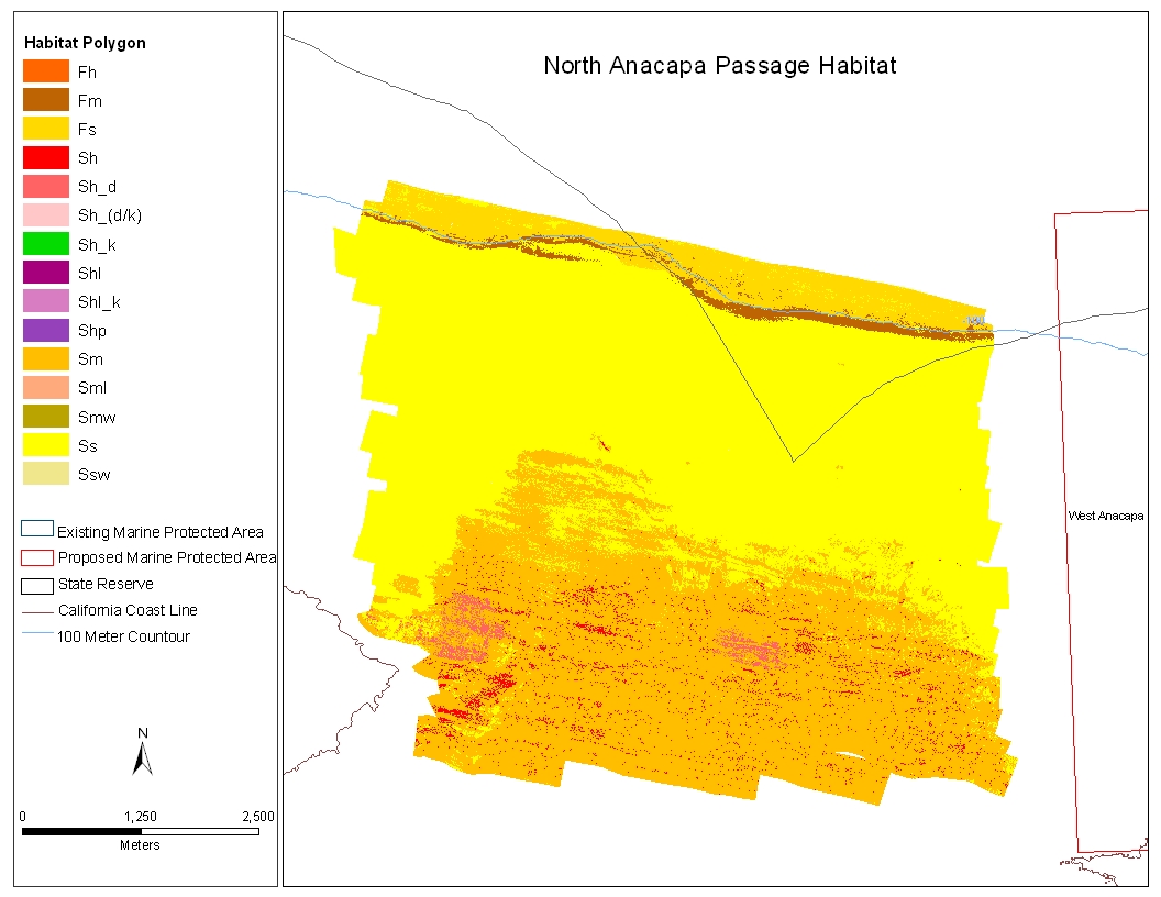
NANPHAB -- Benthic Habitat polygons for North Anacapa Passage (UTM 10N, NAD83)
Edition: (Volume II, Version 1.0, 2005)
Geospatial_Data_Presentation_Form: vector digital data
Series_Information:
Series_Name: Open-File Report
Issue_Identification: 2005-1170
Publication_Information:
Publication_Place: Pacific Coastal and Marine Science Center, Santa Cruz, CA
Publisher: U.S. Geological Survey
Online_Linkage: http://pubs.usgs.gov/of/2005/1170/habitat/nanphab.tgz
Online_Linkage: http://pubs.usgs.gov/of/2005/1170/catalog.html
Online_Linkage: https://doi.org/10.3133/ofr20051170
Larger_Work_Citation:
Citation_Information:
Originator: Guy R. Cochrane
Originator: James E. Conrad
Originator: Jane A. Reid
Originator: Sarah Fangman
Originator: Nadine Golden
Publication_Date: 2005
Title:
Nearshore Benthic Habitat GIS for the Channel Islands National Marine Sanctuary and Southern California State Fisheries Reserves, Volume II Edition: 1.0
Edition: 1.0
Series_Information:
Series_Name: Open-File Report
Issue_Identification: 2005-1170
Publication_Information:
Publication_Place: Pacific Coastal and Marine Science Center, Santa Cruz, CA
Publisher: U.S. Geological Survey
Online_Linkage: https://doi.org/10.3133/ofr20051170
Description:
Abstract:
Benthic habitat polygon coverages have been created for marine reserve locations surrounding the Santa Barbara Basin. Diver, ROV and submersible video transects, bathymetry data, sedimentary samples, and sonar mapping, have been integrated to describe the geological, biological, and oceanographic aspects of habitat. Anacapa Reserve, is part of the Marine Ecological Reserves Research Program (MERRP). The U.S. Geological Survey (USGS), in a cooperative project with Sea Grant-MERRP and investigators at National Marine Fisheries Service (NMFS), the Channel Islands National Marine Sanctuary (CINMS), and National Park Service (NPS) has collected sidescan sonar and video data to produce a polygon coverage. The habitat polygons have attributes for megahabitat, bottom induration, macrohabitat (where macrohabitat observations are available), polygon area, polygon perimeter, and water depth. The habitat GIS shows rocky habitat suitable for rockfish (Sebastes sp.), abalone (Haliotis sp.), and other threatened benthic species from the shoreline out to the 100-m depth limit of the survey.
Purpose:
These data are intended for science researchers, students, policy makers, and the general public. The data can be used with geographic information systems (GIS) software to display geologic and oceanographic information.
Supplemental_Information:
Time_Period_of_Content:
Time_Period_Information:
Range_of_Dates/Times:
Beginning_Date: 20000612
Ending_Date: 20000718
Currentness_Reference: ground condition
Status:
Progress: Complete
Maintenance_and_Update_Frequency: As needed
Spatial_Domain:
Bounding_Coordinates:
West_Bounding_Coordinate: -119.528215
East_Bounding_Coordinate: -119.447256
North_Bounding_Coordinate: 34.081139
South_Bounding_Coordinate: 34.019136
Keywords:
Theme:
Theme_Keyword_Thesaurus: USGS Metadata Identifier
Theme_Keyword: USGS:2378ba37-e903-4978-98c2-ca4fe8a9e11c
Theme:
Theme_Keyword_Thesaurus: USGS Thesaurus
Theme_Keyword: scientific interpretation
Theme_Keyword: sea-floor characteristics
Theme_Keyword: habitats
Theme_Keyword: geology
Theme_Keyword: marine geology
Theme:
Theme_Keyword_Thesaurus: None
Theme_Keyword: U.S. Geological Survey
Theme_Keyword: USGS
Theme_Keyword: Coastal and Marine Hazards and Resources Program
Theme_Keyword: CMHRP
Theme_Keyword: Pacific Coastal and Marine Science Center
Theme_Keyword: PCMSC
Theme_Keyword: Coastal Geology
Theme_Keyword: benthic habitat
Theme_Keyword: fisheries
Theme_Keyword: seafloor
Theme:
Theme_Keyword_Thesaurus: ISO 19115 Topic Category
Theme_Keyword: oceans
Theme_Keyword: biota
Theme_Keyword: geoscientificinformation
Place:
Place_Keyword_Thesaurus: None
Place_Keyword: North Anacapa Passage
Place_Keyword: Channel Islands
Place_Keyword: Channel Islands National Marine Sanctuary
Place_Keyword: Southern California
Place_Keyword: Santa Cruz Islands
Place_Keyword: Santa Barbara
Place_Keyword: Ventura
Place_Keyword: California
Place_Keyword: CA
Place_Keyword: North Pacific Ocean
Place_Keyword: Northern Pacific Ocean
Place_Keyword: United States
Place_Keyword: west coast
Place_Keyword: USA
Access_Constraints: None
Use_Constraints:
USGS-authored or produced data and information are in the public domain from the U.S. Government and are freely redistributable with proper metadata and source attribution. Please recognize and acknowledge the U.S. Geological Survey as the originators of the dataset and in products derived from these data.
Point_of_Contact:
Contact_Information:
Contact_Organization_Primary:
Contact_Organization:
U.S. Geological Survey, Pacific Coastal and Marine Science Center
Contact_Person: PCMSC Science Data Coordinator
Contact_Address:
Address_Type: mailing and physical
Address: 2885 Mission Street
City: Santa Cruz
State_or_Province: CA
Postal_Code: 95060-5792
Country: US
Contact_Voice_Telephone: 831-427-4747
Contact_Electronic_Mail_Address: [email protected]
Browse_Graphic:
Data_Set_Credit:
Thanks to the Staff of the Channel Islands National Marine Sanctuary, the crew of the NOAA R/V Ballena, the crew of the NOAA R/V MacArthur, and the crew of the UCSD R/V Sproul.
Native_Data_Set_Environment: SunOS, 5.8, sun4u UNIX; ArcInfo version 8.0.2