References citedAmante, C. and Eakins, B.W., 2009, ETOPO1 1 Arc-Minute Global Relief Model: Procedures, Data Sources and Analysis: NOAA National Geophysical Data Center, Boulder CO, NOAA Technical Memorandum NESDIS NGDC-24. doi:10.7289/V5C8276M, accessed 6 Feb 2009.
Chase, T.E., Wilde, P., Normark, W.R., Evenden, G.I., Miller, C.P., Seekins, B.A., Young, J.O., Grim, M.S., and Lief, C.J., 1992a, Map Showing Bottom Topography of the Pacific Continental Margin, Cape Mendocino to Point Conception: USGS Miscellaneous Investigations Series I-2090-C, scale 1:1,000,000, http://pubs.usgs.gov/imap/2090/c/
Chase, T.E., Wilde, P., Normark, W.R., Evenden, G.I., Miller, C.P., Seekins, B.A., Young, J.O., Grim, M.S., and Lief, C.J., 1992b, Map Showing Bottom Topography of the Pacific Continental Margin, Point Conception to Point Loma: USGS Miscellaneous Investigations Series I-2089-C, scale 1:1,000,000, http://pubs.usgs.gov/imap/2089/c/
Grim, M.S., Chase, T.E., Evenden, G.I., Holmes, M.L., Normark, W.R., Wilde, P., Fox, C.G., Lief, C.J., and Seekins, B.A., 1992, Map Showing Bottom Topography of the Pacific Continental Margin, Strait of Juan de Fuca to Cape Mendocino: USGS Miscellaneous Investigations Series I-2091-C, scale 1:1,000,000, http://pubs.usgs.gov/imap/2091/c/
NOAA, 2011, GSHHS - A Global Self-consistent, Hierarchical, High-resolution Shoreline Database, version 2.1.1 (March 2011) http://www.ngdc.noaa.gov/mgg/shorelines/data/gshhs/oldversions/version2.1.1/GSHHS_shp_2.1.1.zip
Online Links:
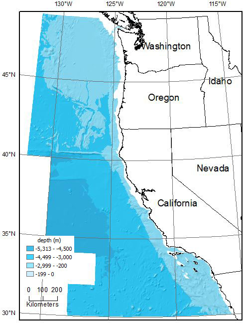
| Range of values | |
|---|---|
| Minimum: | -5313 |
| Maximum: | -200 |
| Units: | meter |
 Cell Size =         1000.000     Data Type: Floating Point
 Number of Rows    =        2150
 Number of Columns =        1465
            BOUNDARY                         STATISTICS
 Xmin =        -268965.464       Minimum Value = -5313.239
 Xmax =        1196034.536       Maximum Value = -200.000
 Ymin =        3317024.756       Mean          = -3361.470
 Ymax =        5467024.756       Standard Deviation = 1143.242
            COORDINATE SYSTEM DESCRIPTION
 Projection             UTM
 Zone                    10
Datum      WGS84
Units     METERS
Spheroid   WGS84
These data are provided to complete a compilation of legacy data, but any users seeking bathymetric data for analysis or display is referred to more recently compiled data such as ETOPO1 (Amante and Eakins, 2009).These data are intended for science researchers, students, policy makers, and the general public. The data can be used with geographic information systems (GIS) software to display geologic and oceanographic information.
CONTOUR cowbathy.shp DEPTH
ENFORCE OFF
DATATYPE CONTOUR
ITERATIONS 40
ROUGHNESS_PENALTY 0.00000000000
DISCRETE_ERROR_FACTOR 1.00000000000
VERTICAL_STANDARD_ERROR 0.00000000000
TOLERANCES 2.50000000000 100.00000000000
CELL_SIZE 1000.00000000000
MARGIN 20
The resultant grid was clipped to the study area.
      MIN             MAX            MEAN            STDV
 -1983.217        2848.723          -4.279         129.323 (meters)
Are there legal restrictions on access or use of the data?Access_Constraints: None. Please see 'Distribution Info' for details.
Use_Constraints:This information is not intended for navigational purposes.Read and fully comprehend the metadata prior to data use. Uses of these data should not violate the spatial resolution of the data. Where these data are used in combination with other data of different resolution, the resolution of the combined output will be limited by the lowest resolution of all the data.Acknowledge the U.S. Geological Survey in products derived from these data. Share data products developed using these data with the U.S. Geological Survey.This database has been approved for release and publication by the Director of the USGS. Although this database has been subjected to rigorous review and is substantially complete, the USGS reserves the right to revise the data pursuant to further analysis and review. Furthermore, it is released on condition that neither the USGS nor the United States Government may be held liable for any damages resulting from its authorized or unauthorized use.Although this Federal Geographic Data Committee-compliant metadata file is intended to document these data in nonproprietary form, as well as in ArcInfo format, this metadata file may include some ArcInfo-specific terminology.
This information is not intended for navigational purposes.This database has been approved for release and publication by the Director of the USGS. Although this database has been subjected to rigorous review and is substantially complete, the USGS reserves the right to revise the data pursuant to further analysis and review. Furthermore, it is released on condition that neither the USGS nor the United States Government may be held liable for any damages resulting from its authorized or unauthorized use.Reference herein to any specific commercial product, process, or service by trade name, trademark, manufacturer, or otherwise does not constitute or imply its endorsement, recommendation, or favoring by the United States Government or any agency thereof.
| Data format: | This WinZip (v.14) file contains the Esri binary grid, browse graphic, ArcGIS layer file, and the associated metadata files. in format ArcInfo GRID format (version Esri ArcGIS 10.2.2) Size: 7.2 |
|---|---|
| Network links: |
http://pubs.usgs.gov/of/2015/1118/data/cowbatg_tif.zip http://pubs.usgs.gov/of/2015/1118/data_catalog.html http://pubs.usgs.gov/of/2015/1118/ https://doi.org/10.3133/ofr20151118 |