Archive of Digital Chirp Subbottom Profile Data Collected During USGS Cruise 10BIM04 Offshore Cat Island, Mississippi, September 2010

Metadata also available as - [Questions & Answers] - [Parseable text] - [XML]

Metadata:

Identification_Information:
Citation:
Citation_Information:
Originator: Arnell S. Forde
Originator: Shawn V. Dadisman
Originator: Jack L. Kindinger
Originator: Jennifer L. Miselis
Originator: Dana S. Wiese
Originator: Noreen A. Buster
Publication_Date: 2012
Title:
Archive of Digital Chirp Subbottom Profile Data Collected During USGS Cruise 10BIM04 Offshore Cat Island, Mississippi, September 2010
Geospatial_Data_Presentation_Form: Archive for Subbottom Profile Data
Series_Information:
Series_Name: U.S. Geological Survey Data Series
Issue_Identification: 724
Publication_Information:
Publication_Place: St. Petersburg, FL
Publisher: U.S. Geological Survey
Online_Linkage: http://pubs.usgs.gov/ds/724/
Description:
Abstract:
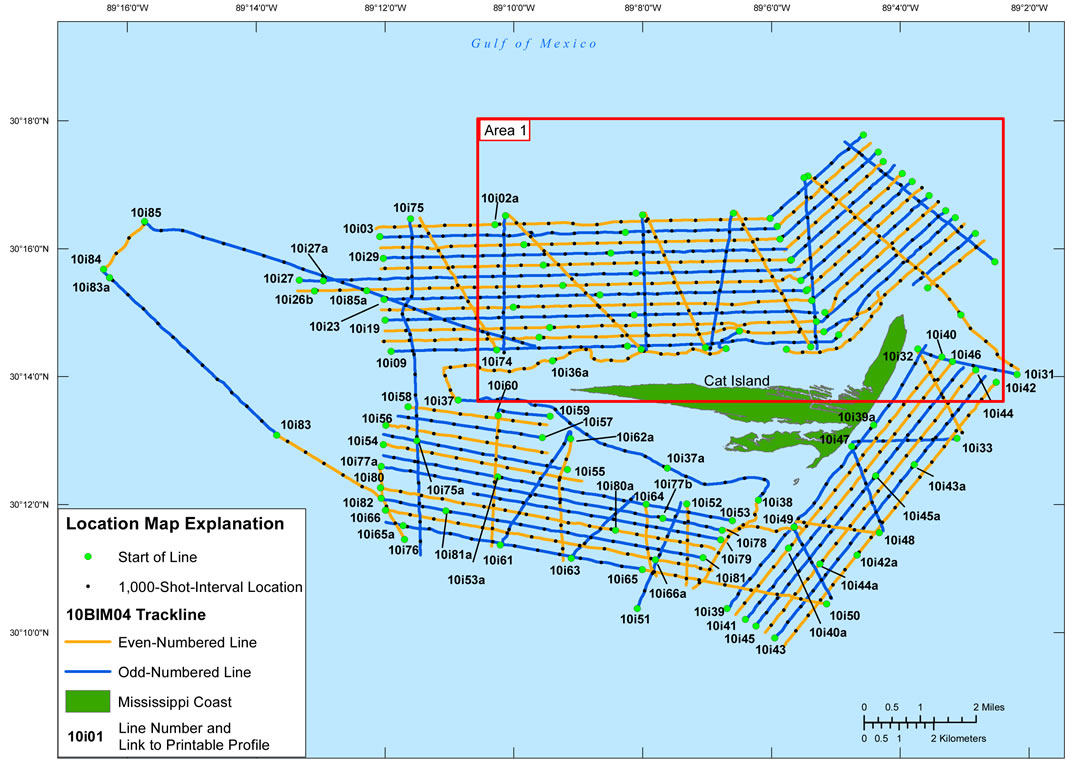
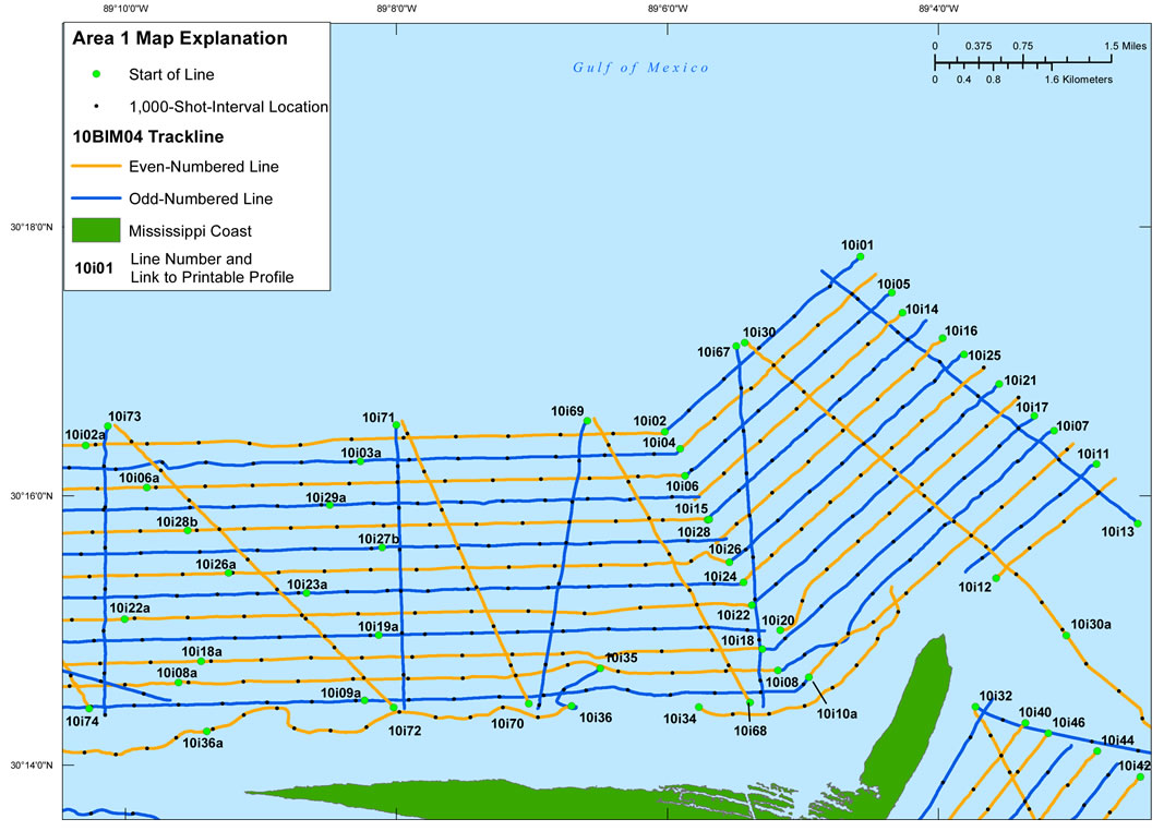
In September of 2010, the U.S. Geological Survey conducted a geophysical survey offshore of Cat Island, Miss., to investigate the geologic controls on barrier island framework. This report serves as an archive of unprocessed digital chirp subbottom data, trackline maps, navigation files, Geographic Information System (GIS) information, and formal Federal Geographic Data Committee (FGDC) metadata. Gained digital images of the seismic profiles are also provided. The archived trace data are in standard Society of Exploration Geophysicists (SEG) SEG Y revision 0 format (Barry and others, 1975) and may be downloaded and processed with commercial or public domain software such as Seismic Unix (SU). Example SU processing scripts and USGS software for viewing the SEG Y files (Zihlman, 1992) are also provided.
These data are also available for viewing using GeoMapApp (http://www.geomapapp.org/) and Virtual Ocean (http://www.virtualocean.org/) multi-platform open source software. In addition, the SEG Y files can also be downloaded from the USGS Coastal and Marine Geoscience Data System (http://cmgds.marine.usgs.gov)
Purpose:
To archive all digital chirp subbottom profile data and associated files collected during cruise 10BIM04.
Supplemental_Information:
The USGS St. Petersburg Coastal and Marine Science Center (SPCMSC) - St. Petersburg, Fla., assigns a unique identifier to each cruise or field activity. For example, 10BIM04 tells us the data were collected in 2010 during the fourth field activity for that project in that calendar year. Refer to http://walrus.wr.usgs.gov/infobank/programs/html/definition/activity.html for a detailed description of the method used to assign the cruise ID. The naming convention used for each subbottom line is as follows: yye##a, where 'yy' are the last two digits of the year in which the data were collected, 'e' is a 1-letter abbreviation for the equipment type (for example, i for 512i chirp), '##' is a 2-digit number representing a specific track, and 'a' is a letter representing the section of a line if recording was prematurely terminated or rerun for quality or acquisition problems.
All Chirp systems use a signal of continuously varying frequency; the EdgeTech SB-512i Chirp system used during this survey produces high-resolution, shallow-penetration (typically less than 50-ms) profile images of sub-seafloor stratigraphy. The towfish contains a transducer that transmits and receives acoustic energy; it was housed within a float system (built at the SPCMSC), which allows the towfish to be towed at a constant depth of 1.07 m below the sea surface. As transmitted acoustic energy intersects density boundaries, such as the seafloor or sub-surface sediment layers, some energy is reflected back toward the transducer, received, and recorded by a PC-based seismic acquisition system. This process is repeated at regular time intervals (for example, 0.125 s), and returned energy is recorded for a specific duration (for example, 50 ms). In this way, a two-dimensional (2-D) vertical image of the shallow geologic structure beneath the towfish is produced.
The seismic source utilized during 10BIM04 consisted of an EdgeTech SB-512i towfish running DISCOVER v. 3.51 acquisition software and towed about 10 m behind the Global Positioning System (GPS) antenna. The data were acquired using a frequency sweep that varied between 1 - 10 kHz and 0.5 - 8 kHz, a 43-kHz sample frequency, and approximately 75-ms record length. Based on survey speeds of 3.5 knots, the shot spacing was about 0.450 m.
The binary portion of the unprocessed seismic data are stored in SEG Y rev. 0 (Barry and others, 1975), IBM float format, which is a standard digital format that can be read and manipulated by most seismic processing software packages; the first 3,200 bytes of the file header are in American Standard Code for Information Interchange (ASCII) format instead of Extended Binary Coded Decimal Interchange Code (EBCDIC) format. The SEG Y formatted trace files have a .sgy extension. The SEG Y files may be downloaded and processed with commercial or public domain software such as Seismic Unix (SU) (Cohen and Stockwell, 2010). Also provided are example SU scripts that allow the user to strip off navigation fixes from the SEG Y headers, along with a fix for every 1,000 shots, and produce a printable, gained GIF image of each profile. The printable profiles provided here are GIF images that were gained using SU software. Refer to the Software page for links to example SU processing scripts and USGS software for viewing the SEG Y files (Zihlman, 1992).
The SEG Y files are available on the DVD version of this report or on the Web, downloadable via the USGS Coastal and Marine Geoscience Data System (http://cmgds.marine.usgs.gov). The data are also available for viewing using GeoMapApp (http://www.geomapapp.org) and Virtual Ocean (http://www.virtualocean.org) multi-platform open source software.
Time_Period_of_Content:
Time_Period_Information:
Range_of_Dates/Times:
Beginning_Date: 20100907
Ending_Date: 20100915
Currentness_Reference: Data collection interval
Status:
Progress: Complete
Maintenance_and_Update_Frequency: None planned
Spatial_Domain:
Bounding_Coordinates:
West_Bounding_Coordinate: -89.272867
East_Bounding_Coordinate: -89.036019
North_Bounding_Coordinate: 30.296317
South_Bounding_Coordinate: 30.163467
Keywords:
Theme:
Theme_Keyword_Thesaurus: USGS Metadata Identifier
Theme_Keyword: USGS:31fc2085-4023-4906-b72b-5c7d68b5b160
Theme:
Theme_Keyword_Thesaurus: ISO 19115 Topic Category
Theme_Keyword: geoscientificinformation
Theme_Keyword: oceans
Theme:
Theme_Keyword_Thesaurus: General
Theme_Keyword: Geology
Theme_Keyword: Coastal information
Theme_Keyword: Marine
Theme_Keyword: Subbottom profile
Theme_Keyword: Seismic reflection
Theme_Keyword: Chirp
Theme_Keyword: Society of Exploration Geophysicists
Theme_Keyword: SEG Y
Theme_Keyword: Barrier Island Mapping
Theme_Keyword: 10BIM04
Theme:
Theme_Keyword_Thesaurus: Data Categories for Marine Planning
Theme_Keyword: distributions
Theme_Keyword: substrate
Theme:
Theme_Keyword_Thesaurus: Marine Realms Information Bank (MRIB) Keywords
Theme_Keyword: seismic reflection
Theme_Keyword: marine geophysics
Theme:
Theme_Keyword_Thesaurus: USGS Thesaurus
Theme_Keyword: seismic reflection methods
Theme_Keyword: sub-bottom profiling
Theme_Keyword: marine geophysics
Place:
Place_Keyword_Thesaurus: Geographic Names Information System (GNIS) Content
Place_Keyword: United States of America
Place_Keyword: Mississippi
Place_Keyword: Gulf of Mexico
Place_Keyword: Cat Island
Access_Constraints: None. These data are held in the public domain.
Use_Constraints:
The U.S. Geological Survey requests to be acknowledged as originator of the data in future products or derivative research.
Point_of_Contact:
Contact_Information:
Contact_Person_Primary:
Contact_Person: Arnell S. Forde
Contact_Organization: U.S. Geological Survey
Contact_Position: Geologist
Contact_Address:
Address_Type: mailing and physical
Address: 600 4th Street South
City: Saint Petersburg
State_or_Province: FL
Postal_Code: 33701
Country: USA
Contact_Voice_Telephone: (727) 803-8747, ext. 3111
Contact_Electronic_Mail_Address: aforde@usgs.gov
Browse_Graphic:
Browse_Graphic_File_Name: http://pubs.usgs.gov/ds/724/maps/10bim04_location.jpg
Browse_Graphic_File_Description:
Location map (fig. 2) of all digital chirp subbottom data collected during USGS Field Activity 10BIM04. This map was created at a scale of 1:120,055.
Browse_Graphic_File_Type: JPEG
Browse_Graphic:
Browse_Graphic_File_Name: http://pubs.usgs.gov/ds/724/maps/10bim04_area1.jpg
Browse_Graphic_File_Description:
Detailed trackline map (fig.3) of digital chirp subbottom data collected during USGS Field Activity 10BIM04. This map was created at a scale of 1:61,715.
Browse_Graphic_File_Type: JPEG
Browse_Graphic:
Browse_Graphic_File_Name: http://pubs.usgs.gov/ds/724/profiles/printable/
Browse_Graphic_File_Description:
Directory containing printable images of all subbottom profiles.
Browse_Graphic_File_Type: GIF
Data_Set_Credit:
Funding and (or) support for this study was provided by the USGS Coastal and Marine Geology Program. We thank R/V G.K. Gilbert captain Dave Bennett (SPCMSC) for his assistance in data collection. This document was improved by the reviews of Nancy DeWitt (USGS) and Emily Klipp (Jacobs Technology, Inc.) of the USGS - St. Petersburg, Fla.
Disc image credit: Descloitres, Jacques, MODIS Land Rapid Response Team at the NASA Goddard Space Flight Center, 2001, Mississippi.A2001361.1640.250m.jpg. Available on-line at http://visibleearth.nasa.gov/view_rec.php?id=2364
Data_Quality_Information:
Attribute_Accuracy:
Attribute_Accuracy_Report:
The validity or accuracy of marine subbottom profiles is highly qualitative and depends on equipment and operating condition variables. Visual inspection of the images rendered from the data did not show any major anomalies.
Logical_Consistency_Report:
This dataset is from one field activity with consistent instrument calibrations.
Completeness_Report:
These data are collected along tracklines (2-D) and are therefore inherently incomplete. Geologic details between lines must be inferred. No data were collected for lines 10i10, 10i23b, 10i62, and 10i77.
Positional_Accuracy:
Horizontal_Positional_Accuracy:
Horizontal_Positional_Accuracy_Report:
As the subbottom data were acquired, the position of the vessel was continuously determined by an Ashtech GPS receiver and subsequently sent to HYPACK 2010 navigation software to ensure a consistent grid spacing during data collection. Positions were recorded and written to the trace headers in latitude and longitude coordinates about every 1 s using navigation from a CodaOctopus F190 Differential Global Positioning System (DGPS) receiver with OmniSTAR High Performance (HP) correction (accurate to within 20 cm). The approximately 10-m offset between the chirp shot and ship's GPS was not accounted for during acquisition nor have the ASCII navigation files and trackline maps been corrected to reflect the offset.
Vertical_Positional_Accuracy:
Vertical_Positional_Accuracy_Report:
These data are not to be used for bathymetry. Two-way travel (TWT) times shown on the printable profile images are relative to the chirp towfish position, not to the sea surface. Any elevation change of the towfish is recorded in the logbooks and isidentifiable on the subbottom profiles by steep, abrupt shifts in the seafloor return.
Lineage:
Process_Step:
Process_Description:
Chirp processing:The SEG Y data were processed with Seismic Unix to produce gained GIF images of the subbottom profiles included in this report. A representative chirp data processing sequence consisted of (1) stripping off navigation data for each shot and converting to SU format, (2) applying automatic gain control, (3) generating a PostScript image of the traces, and (4) converting the PostScript image to a GIF image. For additional SU processing and script details, please refer to http://pubs.usgs.gov/ds/724/software/su/readme.txt.
Process_Date: 2011
Process_Contact:
Contact_Information:
Contact_Person_Primary:
Contact_Person: Arnell S. Forde
Contact_Organization: U.S. Geological Survey
Contact_Position: Geologist
Contact_Address:
Address_Type: mailing and physical address
Address: 600 4th Street South
City: St. Petersburg
State_or_Province: FL
Postal_Code: 33701
Contact_Voice_Telephone: (727) 803-8747, ext. 3111
Contact_Electronic_Mail_Address: aforde@usgs.gov
Process_Step:
Process_Description:
Navigation processing: Shotpoint navigation, start of line, and 1,000-shot-interval location files were extracted using Seismic Unix software and output as ASCII text files; they were then processed with PROJ.4.7.0 (http://trac.osgeo.org/proj/) to generate Universal Transverse Mercator (UTM) coordinates (World Geodetic System 1984 (WGS84), Zone 16, meters) from latitude and longitude coordinates. Text files for each seismic line were concatenated into two comma-delimited text files (for use with Environmental Systems Research Institute (ESRI) software), one containing unique shotpoint positions (10bim04.txt) and another containing the 1,000-shot-interval locations (s10bim04.txt); both can be viewed within the nav folder.
Process_Date: 2011
Process_Contact:
Contact_Information:
Contact_Person_Primary:
Contact_Person: Arnell S. Forde
Contact_Organization: U.S. Geological Survey
Contact_Position: Geologist
Contact_Address:
Address_Type: mailing and physical address
Address: 600 4th Street South
City: St. Petersburg
State_or_Province: FL
Postal_Code: 33701
Contact_Voice_Telephone: (727) 803-8747, ext. 3111
Contact_Electronic_Mail_Address: aforde@usgs.gov
Process_Step:
Process_Description:
All concatenated, comma-delimited text files were imported into ArcGIS and saved as either a point or polyline file in the ESRI shapefile format.
Process_Date: 2012
Process_Contact:
Contact_Information:
Contact_Person_Primary:
Contact_Person: Arnell S. Forde
Contact_Organization: U.S. Geological Survey
Contact_Position: Geologist
Contact_Address:
Address_Type: mailing and physical address
Address: 600 4th Street South
City: St. Petersburg
State_or_Province: FL
Postal_Code: 33701
Contact_Voice_Telephone: (727) 803-8747, ext. 3111
Contact_Electronic_Mail_Address: aforde@usgs.gov
Process_Step:
Process_Description:
Trackline map creation: The trackline map was created using ESRI ArcGIS 10 software. The processed navigation file, 10bim04.txt, was imported into ArcMap 10 and processed using the Points to Lines ArcScript (D. Rathert, http://arcscripts.esri.com/details.asp?dbid=12702) to create a line shapefile of the cruise tracklines (10bim04_trkln). The 1,000-shot-interval file s10bim04.txt and the start of line file 10bim04_s.txt were imported into ArcMap as point shapefiles 10bim04_shots and 10bim04_sol. Please refer to the shapefile metadata included in the ArcGIS map document located under the Software section of this archive for additional details. The location map was exported to Adobe Illustrator v. 14 for further editing then later converted into JPEG format by Adobe Dreamweaver v. 10 Build 4117. The map is unprojected (geographic coordinates, WGS84). The USGS is the originator of all layers used. Please see the ArcGIS readme file for detailed information about the GIS files used in this report.
Process_Date: 2012
Process_Contact:
Contact_Information:
Contact_Person_Primary:
Contact_Person: Arnell S. Forde
Contact_Organization: U.S. Geological Survey
Contact_Position: Geologist
Contact_Address:
Address_Type: mailing and physical address
Address: 600 4th Street South
City: St. Petersburg
State_or_Province: FL
Postal_Code: 33701
Contact_Voice_Telephone: (727) 803-8747, ext. 3111
Contact_Electronic_Mail_Address: aforde@usgs.gov
Process_Step:
Process_Description:
Data Series preparation: In addition to the process steps described above, the following steps were taken to produce this Data Series report: the handwritten cruise logs were scanned and saved as a PDF file, digital logs were created by A. Forde using the cruise logs and personal accounts of the crew members and saved as PDF files, and an HTML-based format was used to present the various parts of this archive.
Process_Date: 2012
Process_Contact:
Contact_Information:
Contact_Person_Primary:
Contact_Person: Arnell S. Forde
Contact_Organization: U.S. Geological Survey
Contact_Position: Geologist
Contact_Address:
Address_Type: mailing and physical address
Address: 600 4th Street South
City: St. Petersburg
State_or_Province: FL
Postal_Code: 33701
Contact_Voice_Telephone: (727) 803-8747, ext. 3111
Contact_Electronic_Mail_Address: aforde@usgs.gov
Process_Step:
Process_Description:
Keywords section of metadata optimized for discovery in USGS Coastal and Marine Geology Data Catalog.
Process_Date: 20170124
Process_Contact:
Contact_Information:
Contact_Organization_Primary:
Contact_Organization: U.S. Geological Survey
Contact_Person: Alan O. Allwardt
Contact_Position: Contractor -- Information Specialist
Contact_Address:
Address_Type: mailing and physical address
Address: 2885 Mission Street
City: Santa Cruz
State_or_Province: CA
Postal_Code: 95060
Contact_Voice_Telephone: 831-460-7551
Contact_Facsimile_Telephone: 831-427-4748
Contact_Electronic_Mail_Address: aallwardt@usgs.gov
Process_Step:
Process_Description:
Added keywords section with USGS persistent identifier as theme keyword.
Process_Date: 20201013
Process_Contact:
Contact_Information:
Contact_Organization_Primary:
Contact_Organization: U.S. Geological Survey
Contact_Person: VeeAnn A. Cross
Contact_Position: Marine Geologist
Contact_Address:
Address_Type: Mailing and Physical
Address: 384 Woods Hole Road
City: Woods Hole
State_or_Province: MA
Postal_Code: 02543-1598
Contact_Voice_Telephone: 508-548-8700 x2251
Contact_Facsimile_Telephone: 508-457-2310
Contact_Electronic_Mail_Address: vatnipp@usgs.gov
Spatial_Data_Organization_Information:
Indirect_Spatial_Reference:
Horizontal X and Y locations (latitude and longitude and Zone 16 UTM coordinates) for each shot are provided as ASCII text files, along with the date and time Coordinated Universal Time (UTC) the shot was recorded.
Spatial_Reference_Information:
Horizontal_Coordinate_System_Definition:
Geographic:
Latitude_Resolution: 0.000001
Longitude_Resolution: 0.000001
Geographic_Coordinate_Units: Decimal Degrees
Geodetic_Model:
Horizontal_Datum_Name: WGS84
Ellipsoid_Name: WGS_1984
Semi-major_Axis: 6378137.000000
Denominator_of_Flattening_Ratio: 298.25722210100002
Entity_and_Attribute_Information:
Detailed_Description:
Entity_Type:
Entity_Type_Label: 10bim04.txt, s10bim04.txt, and 10bim04_s.txt
Entity_Type_Definition: Shotpoint navigation files
Entity_Type_Definition_Source:
Society of Exploration Geophysicists (SEG) Y headers (http://www.seg.org/publications/tech-stand).
Attribute:
Attribute_Label: FID*
Attribute_Definition: Internal feature number.
Attribute_Definition_Source: ESRI
Attribute_Domain_Values:
Unrepresentable_Domain:
Sequential unique whole numbers that are automatically generated.
Attribute:
Attribute_Label: Shape*
Attribute_Definition: Feature geometry.
Attribute_Definition_Source: ESRI
Attribute_Domain_Values:
Unrepresentable_Domain: Coordinates defining the features.
Attribute:
Attribute_Label: UTMX
Attribute_Definition: UTM-X coordinate (Zone 16)
Attribute_Definition_Source: Universal Transverse Mercator Geographic Coordinate System
Attribute_Domain_Values:
Range_Domain:
Range_Domain_Minimum: 281337
Range_Domain_Maximum: 304075
Attribute:
Attribute_Label: UTMY
Attribute_Definition: UTM-Y coordinate (Zone 16)
Attribute_Definition_Source: Universal Transverse Mercator Geographic Coordinate System
Attribute_Domain_Values:
Range_Domain:
Range_Domain_Minimum: 3338756
Range_Domain_Maximum: 3353446
Attribute:
Attribute_Label: Line
Attribute_Definition: Trackline number
Attribute_Definition_Source: U.S. Geological Survey
Attribute_Domain_Values:
Range_Domain:
Range_Domain_Minimum: 10i01
Range_Domain_Maximum: 10i85a
Attribute:
Attribute_Label: Shot
Attribute_Definition: Shotpoint number
Attribute_Definition_Source: U.S. Geological Survey
Attribute_Domain_Values:
Range_Domain:
Range_Domain_Minimum: 1
Range_Domain_Maximum: 11191
Attribute:
Attribute_Label: Lon
Attribute_Definition: Longitude (decimal degrees)
Attribute_Definition_Source: World Geodetic System 1984 Geographic Coordinate System
Attribute_Domain_Values:
Range_Domain:
Range_Domain_Minimum: -89.272867
Range_Domain_Maximum: -89.036019
Attribute:
Attribute_Label: Lat
Attribute_Definition: Latitude (decimal degrees)
Attribute_Definition_Source: World Geodetic System 1984 Geographic Coordinate System
Attribute_Domain_Values:
Range_Domain:
Range_Domain_Minimum: 30.163467
Range_Domain_Maximum: 30.296317
Attribute:
Attribute_Label: YEAR
Attribute_Definition: Year
Attribute_Definition_Source: U.S. Geological Survey
Attribute_Domain_Values:
Range_Domain:
Range_Domain_Minimum: 2010
Range_Domain_Maximum: 2010
Attribute:
Attribute_Label: DOY:HR:MIN:SEC
Attribute_Definition: Day of year:hour:minute:second
Attribute_Definition_Source: U.S. Geological Survey
Attribute_Domain_Values:
Unrepresentable_Domain: Day of year, hour, minute and second of data acquisition
Overview_Description:
Entity_and_Attribute_Overview:
Binary data file: Trace data are available as binary files in SEG Y format. These files have a .sgy extension and range in size from 3.51 to 97.6 MB.
Entity_and_Attribute_Overview:
Graphic image file: Printable versions of the subbottom profiles are available as GIF images, links to these images can be found on the Profiles page or by going to http://pubs.usgs.gov/ds/724/profiles/printable/.
Entity_and_Attribute_Overview:
Navigation file: Navigation files are available as ASCII text files. Provided are raw (unprocessed) shotpoint navigation files, processed shotpoint navigation (10bim04.txt), processed 1,000-shot-interval location (s10bim04.txt), and a start of line file (10bim04_s.txt). Fields/Attributes [FID, Shape] marked above with an asterisk (*) were created by ESRI ArcGIS and are used exclusively by the shapefiles created from the three aforementioned .txt files; these fields are not included in the original navigation files. All remaining attributes listed above in the Entity_and_Attribute_Information section that do not have an accompanying asterisk are found in 10bim04.txt, s10bim04.txt, and10bim04_s.txt.
Entity_and_Attribute_Overview:
GIS file: The GIS project used to create the trackline maps is provided as a .zip file composed of ESRI map documents, shapefiles, and metadata.
Entity_and_Attribute_Detail_Citation:
Barry, K.M., Cavers, D.A., and Kneale, C.W., 1975, Recommended standards for digital tape formats: Geophysics, v. 40, no. 2, p. 344-352. Also available on-line at http://www.seg.org/publications/tech-stand/.
Entity_and_Attribute_Detail_Citation:
Cohen, J.K., and Stockwell, J.W., Jr., 2010, CWP/SU: Seismic Unix Release 41: A free package for seismic research and processing, Center for Wave Phenomena, Colorado School of Mines. Available on-line at http://www.cwp.mines.edu/cwpcodes/index.html.
Entity_and_Attribute_Detail_Citation:
Zihlman, F.N., 1992, DUMPSEGY V1.0: A program to examine the contents of SEG Y disk-image seismic data: U.S. Geological Survey Open-File Report 92-590, 28 p. Also available on-line at http://pubs.er.usgs.gov/usgspubs/ofr/ofr92590.
Distribution_Information:
Distributor:
Contact_Information:
Contact_Person_Primary:
Contact_Person: Arnell Forde
Contact_Organization: U.S. Geological Survey
Contact_Position: Geologist
Contact_Address:
Address_Type: mailing and physical
Address: 600 4th Street South
City: St. Petersburg
State_or_Province: FL
Postal_Code: 33701
Country: USA
Contact_Voice_Telephone: (727) 803-8747, ext. 3111
Contact_Electronic_Mail_Address: aforde@usgs.gov
Contact_Instructions:
All of this report is available online. The SEG Y files are downloadable from the Coastal and Marine Geoscience Data System (http://cmgds.marine.usgs.gov).
Resource_Description: U.S. Geological Survey Data Series 724
Distribution_Liability:
This DVD publication was prepared by an agency of the United States Government. Although these data have been processed successfully on a computer system at the U.S. Geological Survey, no warranty expressed or implied is made regarding the display or utility of the data on any other system, nor shall the act of distribution imply any such warranty. The U.S. Geological Survey shall not be held liable for improper or incorrect use of the data described and (or) contained herein. Reference herein to any specific commercial product, process, or service by trade name, trademark, manufacturer, or otherwise does not constitute or imply its endorsement, recommendation, or favoring by the United States Government or any agency thereof.
Standard_Order_Process:
Digital_Form:
Digital_Transfer_Information:
Format_Name: SEG Y rev. 0
Format_Information_Content:
The SEG Y rev. 0 format (Barry and others, 1975) presented here consists of the following: a 3,600-byte reel identification header, with the first 3,200 bytes consisting of an ASCII header block followed by a 400-byte binary header block, both of which include information specific to line and reel number; a trace data block that follows the reel identification header, with the first 240 bytes of each trace block consisting of the binary trace identification header; and seismic data samples that follow the trace identification header.
File_Decompression_Technique: None
Transfer_Size: 7700
Digital_Transfer_Option:
Offline_Option:
Offline_Media: DVD
Recording_Format: ISO 9660
Compatibility_Information: UNIX, Linux, DOS, Macintosh
Digital_Form:
Digital_Transfer_Information:
Format_Name: map document, shapefile, metadata
Format_Information_Content:
The GIS project used to create the trackline maps is composed of map documents, shapefiles, and metadata. Map documents were created with ESRI ArcGIS 10 software. The shapefiles provided may also be viewed using other versions of ESRI desktop software including their free software or ArcGIS Explorer (http://www.esri.com/software/arcgis/explorer/index.html).
File_Decompression_Technique: unzip
Transfer_Size: 107
Digital_Transfer_Option:
Online_Option:
Computer_Contact_Information:
Network_Address:
Fees: Prices vary.
Ordering_Instructions:
Publications are available from USGS Information Services, Box 25286, Federal Center, Denver, Colo. 80225-0046 (telephone: 1-888-ASK-USGS, e-mail: infoservices@usgs.gov).
Technical_Prerequisites:
Use of SEG Y data requires specialized seismic processing software, such as public domain software Seismic Unix (http://www.cwp.mines.edu/cwpcodes/index.html).
Metadata_Reference_Information:
Metadata_Date: 20201013
Metadata_Contact:
Contact_Information:
Contact_Person_Primary:
Contact_Person: Arnell Forde
Contact_Organization: U.S. Geological Survey
Contact_Position: Geologist
Contact_Address:
Address_Type: mailing and physical
Address: 600 4th Street South
City: St. Petersburg
State_or_Province: FL
Postal_Code: 33701
Country: USA
Contact_Voice_Telephone: (727) 803-8747, ext. 3111
Contact_Electronic_Mail_Address: aforde@usgs.gov
Metadata_Standard_Name: Content Standard for Digital Geospatial Metadata
Metadata_Standard_Version: FGDC-STD-001-1998

This page is <https://cmgds.marine.usgs.gov/catalog/spcmsc/10BIM04_chirp-met.html>
Generated by mp version 2.9.50 on Tue Sep 21 18:18:28 2021